
Bruchstedt
| coat of arms | Germany map | |
|---|---|---|

|
Coordinates: 51 ° 11 ' N , 10 ° 47' E |
|
| Basic data | ||
| State : | Thuringia | |
| County : | Unstrut-Hainich district | |
| Management Community : | Bad Tennstedt | |
| Height : | 218 m above sea level NHN | |
| Area : | 6.8 km 2 | |
| Residents: | 272 (Dec. 31, 2019) | |
| Population density : | 40 inhabitants per km 2 | |
| Postal code : | 99955 | |
| Area code : | 036041 | |
| License plate : | UH, LSZ, MHL | |
| Community key : | 16 0 64 009 | |
| LOCODE : | DE UDT | |
| Address of the municipal administration: |
Platz der Demokratie 95 99955 Bruchstedt |
|
| Website : | ||
| Mayor : | Walter Tückhardt | |
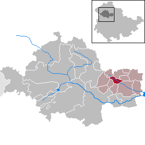
| Location of the community of Bruchstedt in the Unstrut-Hainich district | ||
  |
||

Bruchstedt is a municipality in the Unstrut-Hainich district in Thuringia . It belongs to the Bad Tennstedt administrative community with its seat in the city of Bad Tennstedt .
geography
Bruchstedt is located in the Thuringian Basin , on the southeast edge of the Schlotheim trench , which here follows the Schambach- Oberlauf Fernebach .
history
At the beginning of the 9th century Bruchstedt was first mentioned as Brutstede in connection with Tennstedt ( Dennistede ) in a list of the goods of the Hersfeld monastery built by Archbishop Lullus († 786) of Mainz .
Bruchstedt was originally an exclave of the subordinate rule of the Principality of Schwarzburg-Sondershausen in the middle of the Electoral Saxon office of Langensalza . In 1816, as a result of the Congress of Vienna , Bruchstedt came to the Langensalza district of the Prussian province of Saxony with the surrounding office of Langensalza .
In 1913 the private Langensalzaer Kleinbahn was built by Haussummer to Langensalza via Bruchstedt. This was completely dismantled in 1967 from Haussummer to Kirchheilingen and in 1969.
On the night of May 23rd to 24th 1950, a torrent of the Fernebach caused by a storm devastated the place. Water heights of up to 3.50 meters were reached; an expert opinion assumes that the high water peak had a discharge of 400 m³ / s. Eight citizens and most of the livestock (including 82 cows, 400 pigs and 317 sheep) were victims of the disaster. Seven residents were injured, some seriously. 40 buildings were completely destroyed and over 150 structures were partially badly damaged. In a state-organized aid campaign, the site was rebuilt by 3,000 helpers in 50 days. The new farms were built on a hillside, a kindergarten, a school and a cultural center were built. A park was created on the vacated center. A memorial stone with the names of the eight victims of the disaster commemorates the disaster night. Even today, the rebuilding festival takes place every year in memory of the one-time relief operation.
politics
Municipal council
The Bruchstedt community council consists of six community representatives. Since the local elections on May 26, 2019 , it has been composed as follows:
- Free community of voters: 4 seats
- Free voter community Citizens' initiative for Bruchstedt: 2 seats
mayor
The honorary mayor Walter Tückhardt (FWG for Bruchstedt) was elected on August 15, 2016.

Memorial stone

church

Nave

Church tower with transition to the nave


Individual evidence
- ^ Population of the municipalities from the Thuringian State Office for Statistics ( help on this ).
- ^ Olaf Bellstedt (Red.): 60 years of the Bruchstedt severe weather disaster. = 60 years of the Bruchstedt environmental disaster (= series of publications by the Thuringian State Institute for Environment and Geology 92, ZDB -ID 2073833-X ). Thuringian State Institute for Environment and Geology, Jena 2011.
- ↑ City council election 2019 in Thuringia. Thuringian State Office for Statistics, accessed on July 6, 2019 .
Web links
Anrode | Bad Langensalza | Bad Tennstedt | Ballhausen | Blankenburg | Bruchstedt | Dünwald | Greater Vargula | House summer | Autumn life | Hornsummer | Kammerforst | Kirchheilingen | Grains | Kutzleben | Marolterode | Menteroda | Midsummer | Mühlhausen / Thuringia | Nottertal-Heilinger Heights | Oppershausen | Rodeberg | Schönstedt | Südeichsfeld | Sundhausen | Dead life | Unstrut-Hainich | Unstruttal | Primeval life | Bailiwick