
Rodeberg
| coat of arms | Germany map | |
|---|---|---|

|
Coordinates: 51 ° 13 ' N , 10 ° 18' E |
|
| Basic data | ||
| State : | Thuringia | |
| County : | Unstrut-Hainich district | |
| Fulfilling municipality : | Südichsfeld | |
| Height : | 479 m above sea level NHN | |
| Area : | 26.68 km 2 | |
| Residents: | 2043 (Dec. 31, 2019) | |
| Population density : | 77 inhabitants per km 2 | |
| Postal code : | 99976 | |
| Area code : | 036026 | |
| License plate : | UH, LSZ, MHL | |
| Community key : | 16 0 64 055 | |
| LOCODE : | DE RB2 | |
| Community structure: | 5 districts | |
| Address of the municipal administration: |
Lange Str. 11 99976 Rodeberg |
|
| Website : | ||
| Mayor : | Klaus Zunke-Anhalt ( CDU ) | |
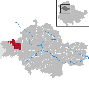
| Location of the municipality of Rodeberg in the Unstrut-Hainich district | ||
  |
||


Rodeberg is a municipality in the Unstrut-Hainich district in Thuringia . The fulfilling municipality for Rodeberg is the rural municipality of Südeichsfeld .
geography
The today bare and agriculturally used, eponymous mountain Rode is with a summit height of 498.2 m above sea level. HN one of the highest elevations on the northern edge of the Hainich . The community is located around 20 km south of Heiligenstadt and 8 km west of Mühlhausen at around 480 m altitude in the Eichsfeld-Hainich-Werratal nature reserve .
Community structure
The districts of Rodeberg:
The districts of Annaberg and Kloster Zella were separated from the municipality of Effelder in 1966 .
history
Struth was a Frankish royal estate . In 1273 Heinrich von Treffurt sold it for 24 silver marks to the Zella monastery , which is now part of the municipality and who also looked after the village as a parish until 1772. The church in Struth was built from 1793 to 1800. Eigenrieden also belonged to the monastery Zella, but until 1802/03 it was in the area of the imperial city of Mühlhausen .
Struth and Eigenrieden were independent communities in the Mühlhausen district since the beginning of the 19th century and belonged to the Prussian province of Saxony until 1944 .
On April 7, 1945, the only major counterattack by the German 11th Army in Thuringia took place from Küllstedt south . His goal - in disregard of the balance of power - was to cut off US troops that had already moved into Mühlhausen and Langensalza. During this "Battle of Struth", by American fighter-bombers and fighting, a large part of the place was destroyed, the local history lists 65 houses, 77 stables, 88 barns and the cigar factory. Numerous soldiers from both sides, as well as 13 residents of the community, were killed. The attack got stuck in Struth. Apart from the church in Struth, little of the old building fabric remained as a result of the destruction in 1945. The residential and farm buildings date from 1946 and after.
After the Second World War, the community was on the edge of the restricted border area until the " Wende " and had belonged to the Erfurt district since 1952 . In 1966, the towns of Annaberg and Kloster Zella, which had been separated from the municipality of Effelder, were reclassified into the municipality of Struth. On June 30, 1994, the unified community of Rodeberg was formed through the merger of Struth and Eigenrieden.
To the north of Struth, on the right of the road to Küllstedt, 27 large wind turbines were erected, which can be seen from afar and characterize the landscape.
Religions
Struth is the seat of the Roman Catholic parish of St. James. In 1934 Pastor Michael Lerch directed his sermon in the church of Struth against the racial and ethnic politics of the National Socialists , whereupon he was denounced and threatened by the Gestapo with being sent to a concentration camp .
Self-satisfied is the seat of the Evangelical Lutheran parish of St. Ulrich.
politics
Municipal council
The council of the municipality of Rodeberg consists of 14 councilors and councilors.
- CDU 8 seats
- Free Voters Rodeberg eV 6 seats
(As of: local election on May 26, 2019 )
mayor
The honorary mayor Klaus Zunke-Anhalt (CDU) was elected on June 6, 2010.
Attractions
- Parish Church of St. James the Elder Ä. in Struth with the representation of "Anna Selbdritt"
- Church of St. Ulrich in Eigenrieden
- Bonifatiuskreuz in Struth, a Gothic stone cross, which is also called "Angerkreuz"
- The Mühlhäuser Landgraben between Eigenrieden and Struth with the Eigenrieder Warte at the western end of the village
- Outstanding views from the Rode and Rain to the Inselsberg and Brocken
- Annaberg with statue of St. Anna (former place of pilgrimage)
- Zella Monastery (built around 1100)
- Schäfersbrunnen (built in 1826, renovated in 2010/11)
- Outdoor pool in Eigenrieden
- Museum and home parlor
- Lutherstein
- Atonement Cross at Eigenrieden (1670)
Individual evidence
- ^ Population of the municipalities from the Thuringian State Office for Statistics ( help on this ).
- ↑ Wolfgang Trappe: 50 years ago in April. War in Eichsfeld . In: Eichsfeld. Monthly magazine of the Eichsfeldes . tape 39 , issue 4, 1995, ZDB -ID 913387-2 , p. 89-96 .
- ^ Federal Statistical Office: Municipalities 1994 and their changes since 01.01.1948 in the new federal states . Metzler-Poeschel, Stuttgart 1995, ISBN 3-8246-0321-7 .
- ↑ Thuringian Association of the Persecuted of the Nazi Regime - Association of Antifascists and Study Group of German Resistance 1933–1945 (Ed.): Local history guide to sites of resistance and persecution 1933–1945. Volume 8: Thuringia. VAS - Verlag für Akademische Schriften, Frankfurt am Main 2003, ISBN 3-88864-343-0 , p. 313.
- ↑ City council election 2019 in Thuringia. Thuringian State Office for Statistics, accessed on July 6, 2019 .
- ↑ Local elections in Thuringia on June 6, 2010. Elections for community and city council members. Preliminary results. Retrieved June 6, 2010 .
Web links
- Community website
- Information on Struth
- Information about the Eichsfeld
- Zella Monastery
- Fair in Struth
Anrode | Bad Langensalza | Bad Tennstedt | Ballhausen | Blankenburg | Bruchstedt | Dünwald | Greater Vargula | House summer | Autumn life | Hornsummer | Kammerforst | Kirchheilingen | Grains | Kutzleben | Marolterode | Menteroda | Midsummer | Mühlhausen / Thuringia | Nottertal-Heilinger Heights | Oppershausen | Rodeberg | Schönstedt | Südeichsfeld | Sundhausen | Dead life | Unstrut-Hainich | Unstruttal | Primeval life | Bailiwick