Oppershausen
| coat of arms | Germany map | |
|---|---|---|
 Help on coat of arms |
Coordinates: 51 ° 8 ' N , 10 ° 27' E |
|
| Basic data | ||
| State : | Thuringia | |
| County : | Unstrut-Hainich district | |
| Fulfilling municipality : | Bailiwick | |
| Height : | 217 m above sea level NHN | |
| Area : | 8.61 km 2 | |
| Residents: | 294 (Dec. 31, 2019) | |
| Population density : | 34 inhabitants per km 2 | |
| Postal code : | 99986 | |
| Area code : | 036028 | |
| License plate : | UH, LSZ, MHL | |
| Community key : | 16 0 64 053 | |
| Address of the municipal administration: |
Hauptstrasse 22 99986 Oppershausen |
|
| Website : | ||
| Mayor : | Florian Baumlein | |
| Location of the municipality of Oppershausen in the Unstrut-Hainich district | ||
Oppershausen is a municipality in the Unstrut-Hainich district in Thuringia . The Vogtei community is a fulfilling community for Oppershausen.
geography
The place Oppershausen is located in the valley of the Gelbrieder Bach on the eastern edge of the Hainich in the immediate vicinity of the Hainich National Park . With the Oppershäuser Holz , however, a large part of the district also takes up central areas of the Hainich and extends to its western edge. The district town of Mühlhausen is about six and a half kilometers from Oppershausen.
history
In the year 900 Oppershausen was first mentioned in the document book of the Erfurt monasteries and monasteries as Opsprechthusen . The place was chosen as the first seat of a Franconian count named Eberhard Oppert. The (earlier) part of the name husen as well as the type of development, which is represented by the gable end facing the street, also point to the Franconian origins . It is assumed that a Franconian settlement stood on the site of the present-day location from 531 to 800.
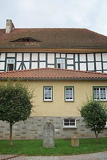
A moated castle ( Oppershausen Castle ) built by Richard von Sebecke ( Seebach ) in 1395 is said to have had a high medieval predecessor. The manor house still preserved today was built in 1754 in the area of the moated castle. The residential tower was demolished in 1973 due to its dilapidation and its stones were used as building material. The remains of the foundation wall of the moated castle are still there.
Oppershausen belonged to the Electoral Saxon Office of Langensalza until 1815 and after its cession to Prussia from 1816 to 1944 to the district of Langensalza in the province of Saxony . From 1408 to 1895 the “castle” and manor belonged to the Lords of Seebach , from 1918 to Anton Knöpfel and Son. These were expropriated without compensation in 1945. The property became community property. After the residential tower was demolished in 1973, the manor house also ached. At times it was used as a hunting lodge by those privileged in the GDR. After the political change , the manor house (in the vernacular "castle") was renovated and the area around the castle square was designed as part of a village renewal program. The manor house now houses apartments and the municipal administration.
Vorwerk Oppershausen
On the eastern edge of the Hainich there has been a manor on Oppershausen's land with the Vorwerk Oppershausen since the Middle Ages. The clearing on the Mittelberg to the west was used for agriculture, in the 19th century and until 1967 as sheep herding. The shepherd lived on the grounds of the estate. From 1973 a shooting range of the National People's Army was built there . From then on, the sheep guards were used by the soldiers of the People's Police and combat troops for target practice with machine guns and machine guns . The sheep farm was demolished and replaced by a fenced, military building complex consisting of accommodation, shed, radio mast, observation tower and a house for practicing house-to-house fighting, which still exists today. However, the military use ended in 1992/93; part of the shooting range was reforested, but most of it was preserved as grassland.
Attractions
A Saxon post milestone (quarter milestone from 1745) in front of the old manor house (castle) documents the former affiliation of the place to the Duchy of Saxony-Weißenfels .
politics
Municipal council
The council of the municipality of Oppershausen consists of 6 councilors and councilors.
(As of: local election on May 26, 2019 )
mayor
Florian Bäumlein was elected mayor on November 4, 2018.
Personalities
- Alfred Nottrott (1837–1924), Protestant missionary and linguist
- Walter Werneburg (1922–1999), painter
Individual evidence
- ^ Population of the municipalities from the Thuringian State Office for Statistics ( help on this ).
- ↑ Information board at the center of Germany near Niederdorla.
- ↑ Michael Köhler: Thuringian castles and fortified pre- and medieval living spaces. Jenzig-Verlag Köhler, Jena 2001, ISBN 3-910141-43-9 , p. 197.
- ↑ Iris Henning: In the half-timbered dress. Former aristocratic seats in the region: Oppershausen Castle. In: Thüringische Landeszeitung , July 16, 2011.
- ↑ a b City council election 2019 in Thuringia. Thuringian State Office for Statistics, accessed on July 6, 2019 .
- ↑ Mayoral elections in Thuringia. Thuringian State Office for Statistics, accessed on July 6, 2019 .


