
Big island mountain
| Big island mountain | ||
|---|---|---|
 Large island mountain seen from the north-west |
||
| height | 916.5 m above sea level NHN | |
| location | Districts Gotha and Schmalkalden-Meiningen ; Thuringia ( Germany ) | |
| Mountains | Thuringian Forest | |
| Dominance | 27.3 km → Sommerbachskopf | |
| Notch height | 228 m ↓ Heuberghaus am Rennsteig southwest of Finsterbergen | |
| Coordinates | 50 ° 51 '4 " N , 10 ° 27' 57" E | |
|
||
| rock | Quartz porphyry | |
| particularities | - Inselsberg transmitter - weather station - observation tower |
|

The Große Inselsberg - south of the Rennsteig , "Großer Inselberg" is the more common spelling - is 916.5 m above sea level. NHN is a striking, wooded and much-visited mountain in the Thuringian Forest in the Thuringian districts of Gotha and Schmalkalden-Meiningen .
The mountain is the highest in the north-western half of the Middle Thuringian Forest and after the Great Beerberg ( 982.9 m ), the Schneekopf ( 978 m ) and the Great Finsterberg ( 944.1 m ) the fourth highest (independent) mountain in Thuringia. It can be easily recognized as a landmark from the north and west within a radius of about 30 to 50 kilometers. For over 1000 years it has marked historical borders - currently between the district of Gotha and the district of Schmalkalden-Meiningen.
geography
location
The Große Inselsberg rises in the northwest of the Thuringian Forest in the Thuringian Forest Nature Park . Its summit, over which the district border runs, is located about 3.2 km north-northeast of Brotterode (district Schmalkalden-Meiningen) and 4 km southwest of Bad Tabarz with its district Cabarz (district Gotha) and Waltershausen beyond these interconnected localities .
Mountain height and side knolls
The height of the island mountain is given in official maps as 916.5 m . The summit is designed as a narrow, approximately 700 m long arched plateau. The steep slopes on the mountain flanks are structured by dents and parts that have been weathered like spurs. The "Inselloch" is on the north side and is the steepest section of the terrain in the western Thuringian Forest with a height difference of around 300 m from the bottom to the mountain peak and slopes of up to 40 degrees.
The mountain also includes the following wooded knolls and spur-like slopes (sorted by position and height):
- Upper Beerberg ( ⊙ ; 831.1 m ),
- Käsberg ( ⊙ ; approx. 805 m ),
- Unterer Beerberg ( Unterberg ; ⊙ ; approx. 769 m ),
- Scharfenberg ( ⊙ ; 769.4 m ),
- Kleiner Inselsberg ( ⊙ ; 705.6 m ); not identical to the parking lot, bus stop and Gasthaus Kleiner Inselsberg (see section weather station ).
Those known as exposed rock formations riding blocks (Noteworthy ⊙ ) and the Venetianersteine ( ⊙ ). These are volcanic tunnels that were exposed as rock cliffs by weathering. They are easy to climb as vantage points for experienced hikers and offer delightful distant views. Block heaps made of weathered debris lie beneath these rock sections.
The geographic dominance emanating from the Großer Inselsberg is the second highest in the mountains at over 27 kilometers.
geology
The Große Inselsberg is a hard quartz porphyry that has been weathered from the surrounding softer layers. The near-surface geological subsurface of the summit region is formed by the so-called Inselsberg quartz porphyries , a formation that belongs to the lower volcanic rocks of the Oberhof series of the Unterrotliegend ( Autunium ). They are therefore of volcanic origin. The quartz porphyries are embedded in the conglomerates, sand and siltstones of Goldlauter sequence to the north and to the Cambrian counting Körnelgneise in the south. Along the Inselsberg Fault in the south of the Inselsberg , an old fault line running in a west-east direction, the transition between the Inselsberg quartz porphyry and the granular gneiss occurs abruptly. On the Reitsteinen, a vertically breaking rock cliff in the southeast of the Großer Inselsberg , the Inselsberg quartz porphyry comes to light.
climate
From a climatic point of view, the Große Inselsberg can be assigned to the montane to high-montane altitude level. The annual mean temperature is + 4.4 ° C. The mean annual precipitation is given as 1103 mm. An additional precipitation of up to 100 mm annually comes from the fog eaves . The temperature extremes are between - 29.0 ° C on February 1, 1956 and + 31.7 ° C on August 9, 2003. The highest daily precipitation was recorded with 73.4 mm on October 13, 1960 and the highest snow depth with 2, 2 m on March 6, 1970. The summit plateau is particularly exposed to the wind, the main wind direction is southwest. Measurements were taken at the then still existing weather station on the Inselsberg summit.
Hydrology
The southern slope of the island mountain belongs to the source area of the island water, which together with the enclosure water forms the Truse southwest of Brotterode . The Ländersgraben, a right tributary of the Emse, rises on the northwest slope . The severity, a left tributary of the Laucha , begins on the eastern slope of the island mountain. The geological boundaries can each be viewed as source horizons .
flora
The potential natural vegetation of the Inselsberg is on the north side of the Harz Labkraut- (Galio harcynici-Fagetum) and on the sun-exposed south side a beech forest (Luzulo-Fagetum). The spruce ( Picea abies ) was brought in for forestry. By nature, it would not be represented on the Großer Inselsberg. Near-natural beech forests have been preserved on the south and north-east side of the island mountain.
“Originally the forests around the island mountain were known as Hercynian mixed mountain forests . It was a mixture of species of wood from common spruce (Picea abies), red beech (Fagus silvatica), silver fir (Abies alba) and various types of wood such as sycamore maple (Acer pseudoplatanus), Norway maple (Acer platanoides), common ash (Fraxinus excelsior), Sycamore elm (Ulmus glabra), hornbeam (Carpinus betulus), sessile oak (Quercus petraea), English oak (Quercus robur), common birch (Betula pendula), black alder (Alnus glutinosa), common larch (Larix decidua), common willow (Salix caprea), Bird cherry (Prunus avium) and others. Today the silver fir (Abies alba) has unfortunately disappeared in our forests, we can still find all other types of wood in the area. "
With the seven star and the woolly riding grass, boreal-montane floral elements of the mountain spruce forest already appear in the summit areas. There are currently no floristic features. Forest reed grass, wavy hair , blueberry , Foxglove , heather , fireweed and Senecio sylvaticus many places influential in the herbaceous layer.
history
_um_1860.jpg)

The mountain was first mentioned as Enzenberc around 1250. In 1649, Duke Ernst the Pious of Gotha had the mountain accessible for forest warden and hunters by building a summit hut.
Duke Ernst II of Saxe-Gotha and Altenburg had a small observatory built on the plateau for astronomical observations and land surveys around 1750 . From 1821 to 1825 Gauss used the visual connection to the Hohen Hagen and the Brocken for the Gaussian land survey (surveying) of a large triangle to orientate his measuring network and to control his other measurements.
The Rennsteig , which used to represent the border between the Duchy of Saxony-Gotha and the Electorate of Hesse ( exclave rule Schmalkalden ), runs over the summit . Boundary stones that document this historical territorial situation have been preserved on the Großer Inselsberg to this day. For this reason, an inn was built on both sides: in 1810 on the Hessian side today's Berggasthof Stöhr and on the Gotha in 1852 today's Berggasthof Stadt Gotha . Pollack writes about this:
“When in the 18th century, perhaps only towards the end of the same, the people's sense of nature awakened more, visits to the Inselsberg became more frequent, so that the forest attendant entrusted with the supervision of the same kept refreshments ready in the cellar of the house and on Saturdays and Sundays the guests were entertained, mostly from close by. Often there was dancing here - in a strange way - and mostly only by young people from Brotteroda, since others could not easily take part in the fun out of fear of fights. From a stable built by Duke Ernst II of Gotha-Altenburg, a real one-story inn was finally made in 1810 further down, southeast of the old house, at the same time as an apartment for a forest attendant, who was forest warden and host at the same time, and the forester Albrecht became the first host . A horse stable some distance to the north soon served as accommodation for migrating cattle. If the number of guests in the small night camp was too large, the room in the tower was used for this purpose. However, this had gradually become so dilapidated that it was destroyed beyond recognition by the storms of 1836. While with the increasing frequency of visitors to the door. Waldes in 1851 the new, spacious guest house was built on the Gotha side and also a small one on the former Hessian side, the remains of the wall of the old tower-like building were later cleared away to make way for a lookout tower with an altan-like plateau on the same spot. The old inn has become an apartment for forest protection soldiers and a Wegwart. "
The pedagogue Karl Volkmar Stoy (1815–1885) is considered the protagonist of the school hiking day . On August 21, 1853, he hiked for the first time with his school community from Jena to the Inselsberg. A memorial stone near the summit reminds of this .
After Prussia's victory in the German War, Kurhessen went to the Kingdom of Prussia in 1866, which from then on shared the summit with the Duchy of Saxe-Coburg and Gotha . In the GDR from 1952 to 1990 the border between the districts of Suhl and Erfurt ran on the mountain.
In the 1960s, a youth hostel was built, which is now exactly between the two inns and is still operated as a youth hostel today.
Forest history


The originally royal forest property was divided up by the Thuringian landgraves and the monasteries, their goal was the clearing and creation of new settlements. The Große Inselsberg itself was spared on the north side because of the steep slopes, on the south side the people of Brotteroder used the relatively flat slopes to create terraced fields, alpine pastures and pastures. The forest area in the upper Emsetal that came into the possession of the Lords of Wangenheim through purchase in 1298 was a forward-looking investment.
The people of Wangenheim had already noticed the gradual disappearance of the forests in the settlements there in their home area in the central Nessetal, the raw material wood was an essential basis for the medieval economy. From 1349 the Lords of Wangenheim were named as the sole owners of the Winterstein estate, including the forests: Hopfenberg , Wolfenstein, Thielberg, Eichleite, Rappach, Lerchenberg and Sandberg. The landgrave (Tenneberg) part was taken over by Duke Johann Casimir in 1596. The forestry management of the forests at that time began in the first half of the 16th century, brought about by the mining activities in the surrounding communities. According to a forest code that only applies to the Hessian area (Trusetal, Brotterode), the rampant consumption of wood was regulated. The use of wood by the mining cooperatives (pit wood), smelters and hammer mills should be secured because they generated state income and also served for armaments. Ancillary operations, such as glassworks, Harzerei, bee and forest pastures and other forest uses were thus heavily regulated.
The increasing shortage of wood in the Hessian part regularly led to attacks on forest districts near the border in the adjacent forests, which also included the Altenstein groves of the dogs from Wenckheim. Claims for damages were often settled by comparing and judging some of the forest workers involved. In the end, the Hessian bailiff even asked for contracts or charcoal supplies at increased prices from the Gotha forest administration, but this was stopped under pressure from the hunting-loving dukes. The first maps and forest descriptions in the Duchy of Gotha were made at the beginning of the 18th century. The first forest management facility was then set up for eight years with eight stand classes. From 1750 the silvicultural activity (planned reforestation) began. The so-called age group forest has emerged from the previous natural forest through increasing use over the past centuries . Unfortunately, this also reduced the stable mixed forest and the cultivation of monotonous spruce stands increased.
Name and interpretation
The striking Große Inselsberg was often used as a landmark for orientation because of its striking shape and location. The forms of names in documents include: Enzenberc (around 1250, also the first mention), Emmiseberg (1370), Encenberc (1430), Ensillbergk (1503), Emseberg (1528) and Enselsberg (1640). In the 17th century there were also poetic alienations: Engelsberg and Heunselsberg. An official attempt to standardize the name on Emsenberg failed because of the stubbornness or the traditional awareness of the population. The inserted "S" before "berg" is linguistically not justified, but more sonorous, which is why the mountain is now called the Großer Inselsberg .
Literature and art
The people of the Inselsberg region know a multitude of legends that are connected with the mountain.
- In addition to the Brocken , the Große Inselsberg is said to have been a preferred destination for witches, who are said to have gathered on the summit for extravagant feasts and orgies riding on their brooms.
- A large number of legends relate to treasures hidden in the mountain and their discovery by the Venetians, who use magical powers and secret incantations to gain access to the interior of the mountain. Local witnesses of these events are usually left behind, as they do not trust the lure of gold and when they return home they only have a fraction of the possible wealth.
- The gaps and crevices in the mountain were home to good-natured dwarfs who were well-disposed towards people, worked diligently in their houses and unrecognized, but were always treated badly or betrayed by their human housemates due to various circumstances. There are many similarities with these beings in the garden gnome known today.
- In his romantic story "Walks through Thuringia", printed in 1838, the author Ludwig Bechstein describes a visit to the Großer Inselsberg with a detailed description of the distant view that was available on that day and the surprising occurrence of a thunderstorm that the hiking group was able to escape by fleeing to the existing inn .
research
In his report, Pollack describes in detail the early history of the Inselsberg house:
“Whether it was used earlier for metric, meteorological or astronomical purposes when Ernst the Pious gave birth in the 30th. Endeavored to promote sciences sunk in slumber again, cannot be stated with certainty, as the chronicle of 1685 only states: “At the loco Optico, their princely. Your Highness, Duke Ernst Hochsel. Memory often used this mountain. ”For this purpose and probably at the same time for a stay on hunts near the mountain, he had a tower-like house built on the highest point in 1649. That this place is particularly well suited for measurements is evident from the fact that in recent years a trigonometric pyramid was erected during the Hessian land survey where only the remains of the wall of the house stood. The house itself, which the author often entered in its structural condition, had a tapering roof covered with shingles, was massive, rounded at the bottom on the north side, was also hexagonal, and contained a horse stable on the lower floor, a kind of kitchen and cellar and a well under the stairs that led to a hall-like room on the upper floor. A hunter or forest warden from the Tabarz forestry department, who oversees the mountain, provided the key. "
To commemorate the surveyors Hansen , Gerling and Gauß , a stone monument with a stylized measuring mark was erected in 1995 .
tourism
The Große Inselsberg is one of the nationally important excursion mountains in Thuringia. This is taken into account by catering and accommodation establishments as well as by maintaining lookout points. The European long-distance hiking trail E3 , mountain hiking trail Eisenach – Budapest (EB) and the Rennsteig run over the mountain . Its summit is accessible via the Großer Inselsberg street with parking spaces for visitors; this branches off the state road 1024 ( Brotterode - Bad Tabarz ) to the east below the summit region . A large car park and tourist infrastructure such as a 1000 m long summer toboggan run and other restaurants are located on the Kleiner Inselsberg mountain saddle . For winter sports enthusiasts, there is a chairlift with a ski slope on the northeast flank of the mountain . Hikers often start a Rennsteig stage at the summit.
Lookout points: The new lookout tower on the summit plateau offers an almost 360-degree panorama. If you do not climb the tower, the visitor has to go to different points, depending on the direction in which he is aiming:
- the best possible view can be found on the north slope, still below the summit, where the Schlotweg crosses the gray path.
- In the area of the youth hostel and the two mountain inns there are vantage points with limited south and east views (Rhön, Dolmar, Gleichberge / Ettersberge, Erfurt Steigerwald).
- north of the radio tower is a lookout point facing north (Hainich, Kyffhäuser, Harz, Hörselberge).
- at the Venetianerstein, below the summit, there is a view in a northerly direction (Wartburg, Hoher Meißner, Hainich, Hörselberge, Eichsfeld, Harz).
Protected areas
|
Big island mountain
|
|
 The Reitsteine - a striking rock section on the east side of the island mountain |
|
| location | Thuringia , Germany |
| WDPA ID | 14487 |
| Geographical location | 50 ° 51 ' N , 10 ° 28' E |
| Setup date | March 30, 1961 |
Since March 30, 1961, the high altitudes with the summit region of the Großer Inselsberg have been designated as the Großer Inselsberg nature reserve ( CDDA no. 14487; 142.5 km² in size); buildings there are excluded from this. Parts of the Thuringian Forest landscape protection area (CDDA no. 20896; designated 1963; 1443.43 km²), the Thuringian Forest fauna-flora-habitat area (from Ruhla to Großer Inselsberg) (FFH no. 5128- 301; 23.42 km²) and the Thuringian Forest bird sanctuary between Ruhla and Großer Inselsberg (VSG no. 5128-420; 22.1 km²).
Buildings
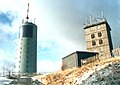
Directional radio tower


There are three towers on the Großer Inselsberg. The 126 m high transmitting antenna and the 43 m high round tower, which were already used as transmission systems during the GDR era, are now operated by Telekom. In GDR times, the angular tower belonged to the series of so-called A towers , as they were built in the GDR in the 1950s and 60s. The towers belonged to the directional radio network (narrow band) of the Central Committee of the SED . As one of the conclusions from the uprising of June 17, 1953 in the GDR, the network was established until around 1973. It was free of employees, transmission points and repeater offices of the Deutsche Post of the GDR. The network was built with two levels. The operating personnel were employees of the party, who were usually trained at the party's own training facility in Brandenburg . In network level 1, the radio links between the central committee and all district lines of the SED were established and in network level 2 all district lines of the party were included in the network.
The required quasi-optical view between transmitter and receiver did not exist in all directions, which made it necessary to set up relay stations or passive radio relay diversion. The tower on the mountain also acted as a relay station. In the second half of the 1960s, the NVA integrated into the network. They invested in the construction of towers, the structural expansion of the party's towers and in the provision of radio relay, telephone and telex switching technology to create their own radio relay network. The party-owned company "Fundament GmbH" with its subsidiaries set up the network.
The telephone and telex traffic in the networks was operated without key technology (crypto technology). As a result, the networks were already cleared up in the 1960s by the telecommunications intelligence service of the German armed forces. As a result, operations in the networks were severely restricted. With the establishment of the "Integrated Staff Network of the Party and State Leadership and the Armed Bodies", also referred to as Special Network 1 , the directional radio networks lost more and more of their importance for daily use. Mainly the NVA network was prepared for use in a state of war. Both networks were transmitted to Deutsche Post free of charge on January 1, 1984. For a fee , the NVA continued to use a defined number of directional radio channels for special properties until 1990. Then the networks were switched off and the angular tower stood empty for a long time until it could be bought by the Tabarz community.
The 21 m high angular tower was redesigned into a lookout tower as part of the “Rennsteig year-round concept”. There are 2 climbing walls on the outside of the tower. An additional 5 m high mast was mounted on this tower, on which an interactive 360-degree HD panorama camera has been mounted since September 2014.
Inselsberg transmitter
On the Großer Inselsberg there is the Inselsberg transmitter with a transmitter building , a 43 m high round tower and a 127 m high transmitter antenna, which were built in 1939 and 1974 respectively. It is a transmitter for ultra-short wave (VHF) and digital television. The transmission area stretches from northern Baden-Württemberg over the whole of northern Bavaria to North Rhine-Westphalia . The programs broadcast from here can also be received in parts of Hesse , Saxony , Saxony-Anhalt and Lower Saxony . In the north, the transmission area ends in Lower Saxony near Hanover .
Weather station
An official weather station of the German Meteorological Service is located 1,300 m south-east of the Großer Inselsberg on the 732 m high saddle Kleiner Inselsberg (with parking lot, bus stop, guest house and summer toboggan run), which is not identical to the Kleiner Inselsberg ( 705 m ; see section mountain height and side knolls) ) and leads to the Trockenberg ( 807.6 m ). At the mountain station of the ski lift ( 901 m ), not far from the summit, a private, semi-professional weather station with WebCAM has been available for several years, which continuously updates the data. Until 1977 there was a weather station from the Meteorological Service of the GDR on the mountain top. Since extreme weather is not infrequently prevalent on the Großer Inselsberg due to its exposed location, which is often not representative of the Thuringian Forest, it was decided to relocate the weather station at that time.
gallery
The two transmission towers (one behind the other) and the abandoned weather station

Youth hostel (left) and Gasthof Stöhr

Trigonometric point on the Großer Inselsberg

View from the former A4 car park Kälberfeld to the Großer Inselsberg ( camera location → )

The summit area of the Großer Inselsberg consists of Inselsberg quartz porphyry

Großer Inselsberg (aerial photo April 2007)


See also
literature
- Julius von Plänckner: The Inselsberg and its view, represented by a 90 inch long panorama and explained by an angle sheet and a short description. (Reprint) . Perthes, Gotha 1995, ISBN 3-623-00715-3 , p. 51 .
- Ludwig Bechstein : Book of legends of the island mountain (reprint) . Rockstuhl Verlag, Bad Langensalza 2005, ISBN 3-937135-72-3 .
- B. Höpfner: On and on the island mountain. A singing journey in rhymes, sagas and songs. Friedrichroda 1881
- Wolfgang Pfauch: On the original forest cover of the Großer Inselsberg nature reserve and adjacent parts of the landscape of the Thuringian Forest. In: Gothaer museum booklet . tape 12 , 1984, ISSN 0138-1857 , pp. 3-30 .
- Rainer Haupt: The Große Inselsberg, a valuable nature reserve and highly frequented recreation center in the Thuringian Forest . Ed .: Council of the District of Erfurt, Forestry Department. Erfurt 1988, p. 26 .
- Wolfgang Zimmermann et al .: Thuringian Forest. Little nature guide . In: Gothaer museum booklet. Treatises and reports from the Museum der Natur Gotha . Booklet 9. August Bebel Gotha printing works, 1990, ISSN 0138-1857 , p. 96 .
- Hans-Jürgen Kahlfuß: The official cartography of the rule Schmalkalden . In: Thüringer Landesvermessungsamt (Ed.): Series of publications . Issue 1. Erfurt 2001, ISBN 3-86140-268-8 , p. 114 .
- Martin Heinze, Helmut Witticke: The roots of Thuringian forestry . In: Thüringer Forstvereins e. V. (Ed.): From the Thuringian forests . tape 18 , 2007, ISSN 0943-7304 , p. 169-179 .
- Roland Geißler : hiking guide to Bad Liebenstein and the Inselsberg , Verlag Rockstuhl, Bad Langensalza 2007, ISBN 978-3-938997-79-6
- Information brochure on history and natural history with pictures and maps of the Inselsberg by H. Stasjulevies, Druckmedienzentrum Gotha GmbH, 2013, ISBN 978-3-939182-56-6
Web links
- Lots of photos and information about the Inselsberg and its surroundings on inselsberg-mineralien.de
- Lots of historical information and photos from the Inselsberg , on brotterode-am-inselsberg.eu
- Home / Directional radio network of the party and the NVA , on jobakampe.magix.net
- Technical documentation on the directional radio network of the party and the NVA (film), on youtube.com
References and comments
- ↑ a b c Map services of the Federal Agency for Nature Conservation ( information )
- ↑ TK 25 - the dominances and celebrities according to highrisepages.de ( memento from October 19, 2014 in the Internet Archive ) differ slightly. However, there is no saddle on the main ridge between Großer Inselsberg and Beerberg that is lower than 688.6 m .
- ↑ Rainer Haupt: The Große Inselsberg, a valuable nature reserve and heavily frequented recreation center in the Thuringian Forest . Ed .: Council of the District of Erfurt, Forestry Department. Erfurt 1988, landscape overview, p. 2-3 .
- ↑ Between Ruhla, Bad Liebenstein and Schmalkalden (= values of our homeland . Volume 48). 1st edition. Akademie Verlag, Berlin 1989, p. 81.
- ↑ Official topographic maps of Thuringia 1: 10,000. LK Schmalkalden-Meiningen, LK Hildburghausen, LK Sonneberg, district-free city of Suhl . In: Thuringian Land Survey Office (Hrsg.): CD-ROM series Top10 . CD 6. Erfurt 1999.
- ↑ a b c Rainer Haupt u. a. (1983): The great island mountain. Landscape conservation and nature conservation in Thuringia, special issue, p. 2.
- ↑ a b c The development of forestry and hunting in the forests of the Winterstein district . In: Winterstein municipality (ed.): Winterstein. Pictures stories and history . Winterstein 1996, p. 32-33 .
- ^ Charles Kittel: Berkeley Physik Kurs 1, Mechanik , 5th, improved edition, Braunschweig / Wiesbaden, 1991, p. 5, comprehensive presentation of this famous Gaussian measurement, on books.google.de
- ^ Heinrich Hess: The Thuringian Forest in ancient times. Forest and hunting pictures. (Reprint) . Publishing house Rockstuhl , Bad Langensalza.
- ↑ Harry Gerlach: Brotterode, Pappenheim, Trusetal, Steinbach . In: Wanderheft . tape 10 . Tourist-Verlag, Leipzig / Berlin 1987, ISBN 3-350-00202-1 , Der große Inselsberg, p. 15-18 .
- ↑ Georg Brückner in his Rennsteig description: “Where does the name Großer Inselsberg come from? In the “Chartarium Reinhartsbrunn” it is called “Cincissberg”. Our often mentioned Frankenstein letter of purchase from 1330 calls it "Emmiseberg". In the "Schlorfschen Chronik", probably written around 1420 by the Eisenacher Rothe, Ludwig the saint points to the "Enzenberc" when he is about to be separated from his very young fiancé and says to his companions: "If this mountain were made entirely of gold, I would rather give him up than Elisabeth. ”In 1505 it is called“ Ensillbergk ”and in 1516“ Ensellbergk ”. In the Saxon-Hessian-Henneberg border comparison in 1528 it is called "Emseberg". The Enselsberg form did not appear until around 1640. During the 17th and 18th centuries, “Heunselberg” changed to “Engelsberg” in “great confusion”. "Who seldom sees people, the great Heunselberg" wrote the Gothic chamberlain and later University Chancellor zu Halle Ludwig von Sekkendorf on 30 quarters in "Praise of the Heunselberg" in 1649; he derived the name from the Hunnic "heunisch" (large). Then it is again "Emsenberg", "Enselberg" or "Enselsberg", derived from "Emse" quelle. "
- ^ Heinrich Weigel The saga of the Hörselberge . quartus publishing house, 2001
- ↑ a b Lotar Köllner: Miners and Venetian legends from the north-western Thuringian Forest . In: Stadtverwaltung Ruhla (Ed.): Ruhlaer sagas . Verlag Löhr, Ruhla 2002, epilogue to the mining and Venetian sagas, p. 39-45 .
- ↑ Ludwig Bechstein: Walks through Thuringia , Olms-Presse, 1978, ISBN 3-487-08159-8 , Chapter 37: Felsenthal and Inselberg , on projekt-gutenberg.org
- ^ Carl Pollack: Origin of the name Inselsberg , Sachsengrün. Cultural history journal from all the lands of the Saxon tribe, Issue 16, Dresden, 1861, pp. 175–177, on books.google.de
- ↑ a b All- round view of the 360-degree HD camera of the observation tower , on panomax.de
- ↑ The Inselsberg observation tower will only open in December , in Thüringer Allgemeine , from October 29, 2014, on thueringer-allgemeine.de
- ↑ Weather overview "Großer Inselsberg" ( 916 m ), with live WebCAM image "Großer Inselsberg" with retrospective images and weather graphics over the entire year and the previous years. Website Ingenieurbüro Industrie Thermografie Krüll., On itk-infrarot.de

Apfelstädtaue between Wechmar and Wandersleben | Apfelstädter Ried | Castle hill with Baldrichstein and herb meadow | Big Island Mountain | Hirschgrund | Jonastal | Little wagon mountain | Oberhardt | Röhnberg | Saukopfmoor | Schloßleite | Seeberg | Siebleber pond | Spittergrund | Unstruttal between Nägelstedt and Großvargula | Front Schwarzbachwiese | Meadows southeast of Fischbach

Arnstein | Bischofswaldung with Stedtlinger Moor | Broad Lakes | Eichelberg | Forstloch - Riedwiesen | Ganswiese | Large deer hide meadow | Hembachwald | Hofberg | Horbel - Hoflar - Birkenberg | Horn with bald head | Monastery forest | Long Rhön | Nesselgrundwiese | Oberhofer Schloßberg | Rhönkopf - Streufelsberg | Rhönwald | Schützenbergmoor | Schwarzbacher Grund | Seimbergswald | Spitzberg | Still | Stoffelskuppe | West slope of Dolmar | Ten-book