
District of Suhl
| Basic data | ||
|---|---|---|
| District capital: | Suhl | |
| Area : | 3,856 km² | |
| Residents : | 549,400 (1989) | |
| License plate : | O | |
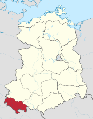
| map | ||
  |
||
The Suhl district was founded in 1952 after the dissolution of the federal states in the German Democratic Republic as the smallest of the 14 districts .
Administrative division
The district comprised one urban district and eight rural districts :
| uh District number (TGS) |
circle | Population on October 3, 1990 | Number of parishes |
Area (ha) at the end of 1990 |
District no. from 1990 to 1994 (AGS) |
||
|---|---|---|---|---|---|---|---|
| all in all | male | Female | |||||
| 1131 .. | Suhl, city district | 55055 | 26523 | 28532 | 1 | 6600 | 16004… |
| 1101 .. | bad Salzungen | 87660 | 42602 | 45058 | 61 | 62162 | 16015… |
| 1102 .. | Hildburghausen | 57756 | 27781 | 29975 | 77 | 69671 | 16023 ... |
| 1103 .. | Ilmenau | 66499 | 31602 | 34897 | 28 | 34684 | 16024… |
| 1105 .. | Meiningen | 67948 | 32769 | 35179 | 60 | 70514 | 16028 ... |
| 1104 .. | Neuhaus / Rwg. | 36461 | 17128 | 19333 | 27 | 32076 | 16030 ... |
| 1106 .. | Schmalkalden | 63263 | 30266 | 32997 | 34 | 40567 | 16036… |
| 1107 .. | Sonneberg | 56910 | 26887 | 30023 | 37 | 30611 | 16040 ... |
| 1108 .. | Suhl-Land | 43639 | 20720 | 22919 | 32 | 38669 | 16042 ... |
| 11 .. | District of Suhl | 535191 | 256278 | 278913 | 357 | 385554 | to the state of Thuringia |
With the re-establishment of the federal states on the territory of the GDR in 1990, the districts were dissolved. The district of Suhl was assigned to the state of Thuringia, and from 1994 to the Free State of Thuringia .
With the district reform, which was implemented in the Free State of Thuringia on July 1, 1994, larger administrative units emerged from the previous districts. The Bad Salzungen district was merged with the Eisenach district to the north in the former Erfurt district to form the Wartburg district. The Hildburghausen district was expanded to include parts of the Suhl district in the north and now forms the Hildburghausen district . The districts of Schmalkalden and Meiningen were combined to form the district of Schmalkalden-Meiningen , the district of Sonneberg was expanded to include the southern part of the district of Neuhaus and now forms the district of Sonneberg , the northern part of the district of Neuhaus was incorporated into the district of Saalfeld-Rudolstadt . The Ilmenau district was merged with the Arnstadt district to the north in the former Erfurt district to form the Ilm district . The district of Suhl was dissolved, parts were incorporated into the city of Suhl; the southern part around Schleusingen came to the district of Hildburghausen, the western and northern part around Zella-Mehlis and Oberhof came to the district of Schmalkalden-Meiningen and the community of Gehlberg in the east of Suhl was incorporated into the Ilm district.
District town and spatial planning
Since the Thuringian Forest clearly delimits the southern part of Thuringia from the northern part, it was difficult to select a border other than the ridge of the mountains when the districts were formed in 1952. Consequently in the Frankish coined Südthüringen with the Suhl district is the smallest district of the GDR. Another problem was the population structure: the Thuringian Forest in particular was densely populated, but there was no large city in the area of the district to which the district could be monocentrically oriented, as in many other districts, such as Erfurt, Leipzig or Magdeburg was the case.
With over 30,000 inhabitants, the industrial city of Sonneberg was the largest city when the district was founded, although it was located in the far south-east of the district, directly on the inner-German border. It was eliminated as a future district town simply because of its location.
The traditional center of the area was Meiningen, centrally located in the district with sufficient infrastructure in every respect. As the former capital of the Duchy of Saxony-Meiningen , all the prerequisites for a district town were already in place. So Meiningen with its around 24,000 inhabitants should also become a district town according to the will of the local SED leadership. However, Meiningen was not industrialized, but rather, as a classic residential city, it was more of an administrative, cultural and service center, in particular of financial services, justice and culture. Furthermore, the bourgeoisie was too strongly represented in the population structure or the proportion of the working class too low. A clear veto by the Central Committee in Berlin then left Meiningen as a district town.
The city of Ilmenau, which was also a center of education (technical center, financial college, glass technical school) is highly industrialized and far enough away from the inner-German border. However, it was also on the edge of the district and had poor transport connections to the other large cities in the region, which also made this city appear unsuitable as a district town.
So the decision was made in favor of the city of Suhl (then 24,000 inhabitants), which, together with the neighboring Zella-Mehlis (then 16,000 inhabitants), was also a heavily industrialized city. The biggest disadvantage of Suhl was the topography: it seemed difficult to enlarge the city. In addition, the infrastructure - especially compared to Meiningen - showed considerable deficits, which, however, also had the advantage that the SED leadership could build something completely new here without having to take historical structures into account. This happened in the following decades, although the district remained relatively polycentric in structure.
Meiningen remained a cultural and historical center, in terms of education it was still Ilmenau and Schmalkalden with their technical universities and industry was not centralized to a decisive extent either. After reunification, the former district town had to face considerable problems due to structural change, and there was also an above-average population decline that continues to this day. In contrast, the three other larger cities in the district were able to compensate for the consequences of reunification somewhat better.
Government and party leaders
Chair of the District Council
- 1952–1958: Fritz Sattler (1896–1964)
- 1958–1967: Wilhelm Behnke (1914–1979)
- 1967–1990: Arnold Zimmermann (1922–2015)
- 1990 : Helmuth Vierling (provisional, * 1945)
- 1990 : Werner Ulbrich (government representative, * 1939)
First secretaries of the SED district leadership
- 1952–1954: Adolf Färber (1912–1987)
- 1954–1956: Kurt Schneidewind (1912–1983)
- 1956–1968: Otto Funke (1915–1997)
- 1968–1989: Hans Albrecht (1919–2008)
- 1989–1990: Peter Pechauf (* 1941)
Dialects or dialects
-
East Franconian dialects
-
Main Franconian dialects
- Grabfeldisch in the districts of Meiningen and Hildburghausen
- Hennebergisch in the districts of Schmalkalden, Meiningen, Suhl, Hildburghausen and Bad Salzungen
- Itzgründisch in the districts of Sonneberg and Hildburghausen
- Rhöner Platt , a dialect of East Hesse , in the Bad Salzungen and Meiningen districts
- Upper Franconian in Heinersdorf in the Sonneberg district
-
Main Franconian dialects
-
Thuringian dialects
- Ilmthuringian in the Neuhaus district
- Central Thuringia in the Ilmenau district
- Southeast Thuringia in the Neuhaus district
Further data

- Size: 3876 square kilometers, 50% of which is forest
- Industry: Forestry, wood processing and processing, mining (potash salt, barite), mechanical engineering, vehicle construction ( mopeds ), rail vehicle construction, hunting and sporting weapons, household appliances, electrical engineering, microelectronics, glass, toy and porcelain industries .
- Biggest cities:
| city | Inhabitants (1950) |
Population (1984) |
Population (2005) |
|---|---|---|---|
| Suhl | 24,020 | 56,345 | 42,689 |
| Ilmenau | 19,108 | 29,481 | 26,737 |
| Sonneberg | 30,182 | 28,400 | 23,805 |
| Meiningen | 23,484 | 25,892 | 21,448 |
| bad Salzungen | 10,006 | 21,335 | 16,504 |
| Schmalkalden | 12,665 | 17,410 | 17,910 |
| Zella Mehlis | 16,914 | 13,921 | 12,245 |
| Hildburghausen | 7,568 | 11,258 | 12,296 |
The district Suhl was the smallest district of the GDR and was jokingly "Autonomous Mountain Republic", " S ozialistisches u nterentwickeltes H inter l called and" or "Mountain Republic Südthüringen".
coat of arms
Due to the seal order of the GDR of May 28, 1953, all regional coats of arms lost their meaning as brands or seals. However, the coats of arms of the cities and districts were still used on buildings or in publications without fulfilling an official function. The coat of arms of the Suhl district used in some books actually shows the coat of arms of the city of Suhl. The seal coat of arms of the GDR was official. It was not until the municipal constitution of the GDR of May 17, 1990 that municipalities and districts were allowed to use coats of arms again and use them as seals.
See also
- District Court Suhl
- Holdings of the SED district leadership in Suhl in the Meiningen State Archives
- Holdings of the District Assembly / Council of the District of Suhl in the Meiningen State Archives
Web links
Individual evidence
Cottbus | Dresden | Erfurt | Frankfurt (Oder) | Gera | Hall | Karl-Marx-Stadt | Leipzig | Magdeburg | Neubrandenburg | East Berlin (equivalent) | Potsdam | Rostock | Schwerin | Suhl