
Schmalkalden district
| Basic data (as of 1994) | |
|---|---|
| Existing period: | 1952-1994 |
| District : | Suhl |
| Administrative headquarters : | Schmalkalden |
| Area : | 405.69 km² |
| Residents: | 64,552 (Dec. 31, 1989) |
| Population density: | 159 inhabitants per km² |
| License plate : | O (1953-1990) OO, OP, OR (1974-1990) SM (1991-1994) |
| Postcodes : | 64xx (old) |
| Circle structure: | 34 municipalities (December 31, 1989) |
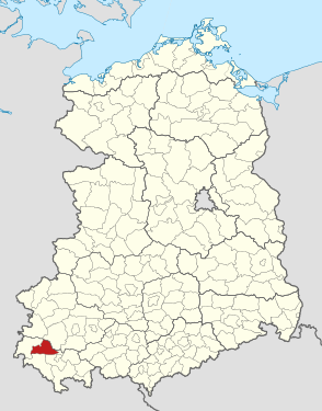
| Location of the district in the GDR | |
  |
|
The Schmalkalden district was a district in the Suhl district of the GDR . From 1990 to 1994 it existed as the district of Schmalkalden in the state of Thuringia . Today his area is in the district of Schmalkalden-Meiningen in Thuringia. The seat of the district administration was in Schmalkalden .
geography
landscape
Even then, the Schmalkalden district united the landscape of the Thuringian Forest , the Werra valley and the Vorderen and Auersberger Kuppenrhön .
The highest point is the Große Inselberg with 916.5 m, north of Brotterode, the lowest point in the Werra valley with approx. 242 m at Breitungen.
The Rennsteig in the north-east formed the border with the district of Gotha , without taking over the old borderline of the old district of Herrschaft Schmalkalden, the Schmalkalde , in the upper reaches.
Neighboring areas
The district of Schmalkalden bordered clockwise in the north, beginning with the districts of Gotha , Suhl-Land , Meiningen and Bad Salzungen .
history
The district was rebuilt during the administrative reform on July 25, 1952 and in the eastern part resembled the old district of Schmalkalden , which was dissolved in 1950 , and was named district of Herrschaft Schmalkalden until the end of January 1946 .
In this way, the importance of the long-standing old circle was taken into account to a certain extent, whether by chance or deliberately.
On May 17, 1990, the district was renamed the district of Schmalkalden.
Circle dissolution
With the district reform, which was implemented in the Free State of Thuringia on July 1, 1994, the districts of Schmalkalden and Meiningen and parts of the district of Suhl were combined to form the new district of Schmalkalden-Meiningen .
Efforts, especially by re-established historical societies, to take account of the historical role of the old district in the reorganization of the districts in 1994, did not find support from the responsible authorities. The city of Schmalkalden lost the seat of authorities and offices without any significant compensation.
aftermath
The constituency of Schmalkalden-Meiningen II includes the former municipalities of the Schmalkalden district including Viernau .
Some clubs, such as the fire brigade and football, as well as the media in reporting, still refer to the old district when making comparisons or statistics.
The territory of the church district of Schmalkalden corresponds to that of the old district of Schmalkalden.
Archives
- In the current city and district archive of Schmalkalden in the cultural association of the district of Schmalkalden-Meiningen, u. a. records of the old group are also kept according to the provenance principle .
- Documents on the commercial enterprises are in the Meiningen State Archives, Dept. Regional Economic Archives Suhl.
Places and communities
From the previous places of the old rule, Altersbach , Asbach , Barchfeld , Bermbach , Breitenbach , Herrenbreitungen , Brotterode , Fambach , Floh , Grumbach , Herges-Hallenberg , Heßles , Hohleborn , Mittelstille , Mittelschmalkalden , Oberschönau , Pappenheim , Reichenbach , Rotterode , Schnellbach , Seligenthal , Springstille , Steinbach-Hallenberg , Struth-Helmershof , Trusetal , Unterschönau , Volkers , Wahles and Winne were separated from Barchfeld and added to the Bad Salzungen district. After the unification of the places Frauenbreitungen and Altenbreitungen with the above-mentioned Herrenbreitungen in 1950, this municipality Breitungen belonged to the district.
The Meeninger and partly Isenach villages Eckardts , Georgenzell , Helmers , Möckers , Niederschmalkalden , Rosa , Roßdorf , Schwallungen and Wernshausen were added from the Werra Valley and the Rhön .
License Plate
Motor vehicles (with the exception of motorcycles) and trailers were assigned three-letter distinctive signs starting with the letter pairs OO , OP and OR from around 1974 to the end of 1990 . The last number plate series used for motorcycles was OZ 00-01 to OZ 20-00 .
At the beginning of 1991 the district received the distinguishing mark SM .
Individual evidence
- ↑ a b Federal Statistical Office (ed.): Municipalities 1994 and their changes since 01.01.1948 in the new federal states . Metzler-Poeschel, Stuttgart 1995, ISBN 3-8246-0321-7 .
- ^ Government Gazette for the State of Thuringia, Part I: Collection of Laws, No. 5/1946 P. 30>
- ↑ Law on the self-administration of municipalities and districts in the GDR (municipal constitution) of May 17, 1990
- ^ Norbert Moczarski et al: Thüringisches Staatsarchiv Meiningen. Department of the Regional Economic Archive South Thuringia in Suhl . A brief inventory overview. Ed .: Thuringian State Archives Meiningen. 1st edition. Druckhaus Offizin Hildburghausen, 1994, p. 86 .
- ↑ Andreas Herzfeld: The history of the German license plate . 4th edition. German Flag Society V., Berlin 2010, ISBN 978-3-935131-11-7 , pp. 302 .
- ↑ Andreas Herzfeld: The history of the German license plate . 4th edition. German Flag Society V., Berlin 2010, ISBN 978-3-935131-11-7 , pp. 554 .
Web links
1922–1952: Altenburg | Altenburg (city) | Apolda (city) | Arnstadt | Arnstadt (city) | District Department Camburg | Eisenach | Eisenach (city) | Erfurt | Erfurt (city) | Gera | Gera (city) | Gotha | Gotha (city) | Greiz | Greiz (city) | Heiligenstadt | Hildburghausen | County of Hohenstein | Ilfeld | Jena | Jena (city) | Langensalza | Meiningen | Mulhouse | Mühlhausen (city) | Nordhausen (city) | Rudolstadt | Saalfeld | Schleiz | Schleusingen | Reign of Schmalkalden | Sondershausen | Sonneberg | Stadtroda | Weimar | Weimar (city) | Weissensee | Worbis | Zella-Mehlis (city) | Ziegenrück . 1952–1994: Altenburg | Apolda | Arnstadt | Artern | Bad Salzungen | Eisenach | Eisenberg | Erfurt-Land | Erfurt (city) | Gera-Land | Gera (city) | Gotha | Greiz | Heiligenstadt | Hildburghausen | Ilmenau | Jena-Land | Jena (city) | Langensalza | Lobenstein | Meiningen | Mulhouse | Neuhaus / Rwg. | Nordhausen | Pößneck | Rudolstadt | Saalfeld | Schleiz | Schmalkalden | Schmölln | Sömmerda | Sondershausen | Sonneberg | Stadtroda | Suhl-Land | Suhl (city) | Weimar-Land | Weimar (city) | Worbis | Zeulenroda .