Truse Valley
|
Truse Valley
City of Brotterode-Trusetal
|
|
|---|---|
| Coordinates: 50 ° 46 ′ 48 ″ N , 10 ° 24 ′ 40 ″ E | |
| Height : | 357 m |
| Area : | 25.88 km² |
| Residents : | 3914 (Dec. 31, 2010) |
| Population density : | 151 inhabitants / km² |
| Incorporation : | December 1, 2011 |
| Postal code : | 98596 |
| Area code : | 036840 |
|
View of the place
|
|
Trusetal is a former municipality and state-approved resort in the district of Schmalkalden-Meiningen in the south of Thuringia , north of Schmalkalden . On December 1, 2011, the town of Brotterode was incorporated into Trusetal and Trusetal was renamed "Stadt Brotterode-Trusetal ".
history
The communities of the Truse Valley were first mentioned in a document in 1185. Hardware was made since the 14th century. Iron ore has also been mined since the 16th century. The mining was discontinued 1991st From 1899 to 1969 the narrow-gauge Trusebahn ran from Wernshausen to Herges-Vogtei.
During the time of National Socialism between 1934 and 1937, 18 people from the villages that are now part of Trusetal were victims of forced sterilization in the hospital in Schmalkalden . During the Second World War , 143 prisoners of war as well as women and men from the countries occupied by Germany had to do forced labor : at the Reum company and in the Klinge iron ore mine . At least two women were the victims of forced labor.
The municipality of Trusetal was created on July 1, 1950 through the merger of the previously independent municipalities of Herges-Auwallenburg , Trusen , Elmenthal and Laudenbach . The district of Wahles was incorporated in 1994. It is named after a small river, the Truse . On December 1, 2011, the town of Brotterode was incorporated into Trusetal and Trusetal was renamed "Stadt Brotterode-Trusetal".
Population development
Development of the population (December 31) :
|
|
|
- Data source: Thuringian State Office for Statistics
Local partnerships
A partnership with Nentershausen in Hessen has existed since 1990 .
Culture and sights
Museums
- In the Heimatstube, a half-timbered house, the history of the place can be seen through exhibits.
- The Hühn visitor mine provides impressions of the mining of heavy and fluvial rock and shows equipment and tracks.
Buildings
- The landmark of the place is the Trusetal waterfall . This artificial, 58 m high waterfall was created in 1865 under the direction of the Specht Building Council. The Zwergenpark , a station on the German Toy Road , is in the immediate vicinity .
- The Wallenburg Tower from the 13th century, a remnant of Wallenburg Castle , which was almost completely destroyed in the Thirty Years' War , offers a panoramic view over the Werra valley to the Vorderen Rhön .
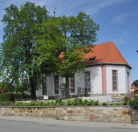
- Trusetal village church
Personalities
- Klaus Krug (* 1941), chemist, science historian and university professor
- Mathias Jung (* 1958), biathlete
- Frank Ullrich (* 1958), 1980 Olympic champion in biathlon, national coach
- Vicki Vomit (* 1963), musician and cabaret artist
- Alexander Wolf (* 1978), biathlete
literature
- Between Ruhla, Bad Liebenstein and Schmalkalden. Results of the local history inventory in the areas of Ruhla and Schmalkalden (= values of our homeland . Vol. 48). Akademie-Verlag, Berlin 1989, ISBN 3-05-000378-2 , p. 96 f.
- Roland Geißler : hiking guide to Bad Liebenstein and the Inselsberg. Hikes and bike tours between Bad Salzungen, Ruhla, Eisenach, Trusetal, Brotterode and the Rennsteig. Rockstuhl, Bad Langensalza 2007, ISBN 978-3-938997-79-6 .
- August Trinius : In the Trusenthale . In: The Gazebo . 1901, p. 247-250 .
Web links
Individual evidence
- ↑ Thuringian Association of the Persecuted of the Nazi Regime - Association of Antifascists and Study Group of German Resistance 1933–1945 (Ed.): Local history guide to sites of resistance and persecution 1933–1945. Volume 8: Thuringia. VAS - Verlag für Akademische Schriften, Frankfurt am Main 2003, ISBN 3-88864-343-0 , p. 260.
- ↑ StBA: Area changes from January 1st to December 31st, 2011
- ↑ Dwarf Park Trusetal on Thuringia.info, accessed on August 16, 2017


