
Fort Eben-Emael


Fort Eben-Emael is a 20th century Belgian fortress . It was the Belgian answer to the experiences of the First World War, a penetration of Belgium by German troops with the aim of France and thus also complemented the French Maginot Line .
history
The huge fortress was built between 1932 and 1939 as the northernmost facility of the Liège fortress ring and named after the small town of the same name directly adjacent.
The fort was conquered on May 10 and 11, 1940 during the western campaign by a German commando , landed with gliders , using a new type of shaped charge from the German pioneers . The fortress was captured and, like the three bridges, one of which had already been blown up, defended against Belgian counter-attacks until the heads of the German 18th Army arrived from Aachen. The battle was a decisive victory for the German troops. The airborne troops suffered losses, but they managed to hold the bridges until the arrival of the German forces. The possession of the fort contributed significantly to the success of the western campaign.
Eben-Emael has been a museum since 1999, which can be visited once a month on Sundays. There are also guided tours in German. The outdoor facilities are freely accessible. The traces of the at times very fierce battle for the fort are still unmistakable; so all the destroyed cannons and armor parts are still there.
Strategic location
The fort is located on the Albert Canal, which was a strategic point for the defense of East Belgium. Its main task was to make the passage over the Albert Canal and the Maas impossible. It also protected the "Trouée de Visé" (Gate of Visé), d. H. the Meuse valley between Visé and Maastricht. The strategic task of the fort was to offer resistance to a possible attacker from the east for a long time until the assistance of the Allies could take effect. For this purpose, it was supposed to secure the bridges over the Albert Canal of the three roads leading from Maastricht to Belgium with its cannons.
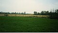
The fort is located ten kilometers south of the Dutch city of Maastricht on St. Pieter Mountain above the western bank of the Meuse . Below the fort, the Albert Canal branches off from the Meuse towards Antwerp . The canal breaks through the St.-Pieter-Berg in a 65 m deep incision and thus forms one of the fortress moats.
In some respects the fort is similar to the facilities built at the same time on the French Maginot Line , while in other details it differs from it. The ground plan of the fort forms an irregular pentagon with an area of 0.75 km²; with the shape of the floor plan, the tradition of French fortification builders of the 16th and 17th centuries was continued. About 0.45 km² form the "roof" of the fort. These expansions make Eben-Emael the largest fort built to date.
Dimensions and armament
With several gun turrets, casemates, more than five kilometers of underground passages, a crew of around 1,200 Belgian soldiers and an above-ground roof of almost half a square kilometer, Eben-Emael was the largest single fortress in the world to date. In many respects, the Belgian fortress even surpassed the bunker works of the French Maginot Line that were built at the same time.


Primary armament
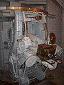
- The dome 120 as a rotatable tank dome t with a total mass of 450 and two guns from Caliber mm 120
- The two domes north and south, which could be sunk under the surface of the fort when not in use. Both domes were rotatable and armed with two 75 mm cannons each.
- The two casemates Maastricht 1 and 2, which act to the north, and the two casemates Vise 1 and 2, which act towards the south. All of these casemates were armed with three 75 mm cannons each.
- In addition, three dummy domes made of sheet metal the size of dome 120 were erected. Two were in the northern part of the fortress plateau and one south of the north dome outside the anti-tank ditch. They should make the fort look even more armed than it was.
Close armament
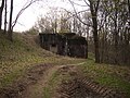
- Block I as the main entrance
- Block II
- Block IV
- Block V
- Block VI
- Canal north
- Canal south
- Machine gun bunker Mi-Nord
- Machine gun bunker Mi-Süd
- and block 01 to the south, outside the fort
The latter block was connected to the fort by an underground passage. All of these blocks had armored observation posts, searchlights and 60 mm caliber cannons. In three of the blocks, larger observation posts for the command line were built. These were the spy domes 'Eben 1' on Block 01, 'Eben 2' on Plant 'Mi Nord' and 'Eben 3' on the casemate 'Maastricht 2'.
Passive armament

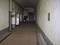
In addition to the incision of the Albert Canal in the east, there were other (partially water-filled) trenches, walls for anti-tank defense and other obstacles to the approach. The underground extension of the corridors within the fort was over 5.3 km at a depth of up to 55 m. The entire air supply to the fort was through special filters, as the planners were still very much aware of the experience of the First World War with regard to the use of poisonous gas .
The fort's crew consisted of 1200 soldiers, half of whom (500) were on duty in the fort and the other half (also 500) were stationed in the surrounding barracks . The remaining 200 consisted of the permanent manning of the fort, doctors, nurses, cooks, etc. The change of duty took place every seven days on Friday. Only in the event of war would all 1200 soldiers have been stationed inside the fortress at the same time.
rating
The new technology of the shaped charge by pioneers showed in 1940 that any fortress construction can be overcome. In particular, the military in Switzerland were dismayed by the Eben-Emael case because they saw their defensive strategy with fortifications (→ Schweizer Réduit ) at risk. The military usefulness of the Maginot Line, which was built at great expense by France, was thus called into question. In the second part of the western campaign it became apparent that the Maginot Line was militarily questionable because many French divisions were tied to it.
Picture gallery

Exhaust chimney

Block 01

Bunker Kanal Nord from the north

Bunker canal north from east

Detailed view of the Bunker Canal North from the east

Ventilation shaft to the Albert Canal
North dome

South dome

Cover of a dummy dome that is in front of the entrance today

Casemate Maastricht 1

Wed North, Vise 2, dome 120 (from left)

Casemate Visé 1
75mm gun in Visé 2
entrance
Machine gun bunker south

bunker


.JPG)
Web links
literature
- Milan Blum, Martin Rábon, Uwe Szerátor: The attack. Volume 1, 287 p., Association of Friends of the Czechoslovak Fortifications Brno, Brno 2007, ISBN 80-86463-23-0 (detailed description of preparation, execution and effects of the attack, lots of photos, maps and original documents).
- Milan Blum, Martin Rábon, Uwe Szerátor: The attack. Volume 2, 354 p., Association of Friends of the Czechoslovak Fortifications Brno, Brno 2008, ISBN 80-86463-28-1 (detailed description of the facility and the history of the fort's construction, reports of operations and combat, photos, original documents).
- Simon Dunstan: Fort Eben Emael. The key to Hitler's victory in the West. (Fortress Volume 30), Oxford, New York 2005, ISBN 1-84176-821-9 .
- Ekkehardt Tautz: The Belgian lock fort Eben Emael. In: Mars - Yearbook for Defense Policy and Military Affairs 6 (2000), pp. 363–397.
- René Viegen: Fort Eben Emael. Dépôt légal D / 1990/5224/05, German edition, Belgium 1990.
- Jens Oebser: German air landings on May 10, 1940 - Fort Eben Emael and the bridges on the Albert Canal. Jena, 2009. ISBN 978-3-9813160-0-1 .
- Günther Schalich: Eben-Emael. Part I, II, as IBA-Sd-Hefte 7, 8, Aachen 1984/85.
Individual evidence
- ↑ Florian Stark: Eben-Emael 1940: 82 paratroopers against the largest fort in the world . In: THE WORLD . May 13, 2015 ( welt.de [accessed February 5, 2020]).
Coordinates: 50 ° 47 ′ 50 ″ N , 5 ° 40 ′ 51 ″ E