
Werra

The Werra is the eastern and right of the two main source rivers of the Weser and with a length of 299.6 km also the longer one, because the western and left Fulda is only 220.7 km long. It flows in Thuringia , Hesse and Lower Saxony .
The Werra rises in the Thuringian Slate Mountains near Fehrenbach in southern Thuringia. After its uppermost course it mostly flows in a north-westerly direction through the west of Thuringia and the north-east of Hesse. In the south-east of Lower Saxony it then unites in Hann. Münden with the Fulda to the Weser, which flows to the North Sea .
Origin of name
In the first millennium AD, Werra and Weser were not distinguished by name and the Werra was viewed as the “real” source river of the Weser. The history of the name proves that the Werra is the actual upper reaches of the Weser , since the names Werra and Weser are etymologically identical (see also the section on origin of the name of the article Weser ).
In 775 the name Uiserra is documented for the Werra near Salzungen, in 933 the form Viseraha occurs, in which the Germanic -aha "water" was appended to the river name. In 1014 it became Werraha and finally Werra for short by adjusting / sr / to / rr /. Thus the Werra name is etymologically identical to the name of the Weser, for which the Old High German Wesera , Wisara , Wisura and also - with an appended -aha - Wiseraha is occupied. It was not until New High German that the names Werra and Weser were clearly separated and used as a designation for the upper and lower reaches of the same river.
The Latinized form Visurgis in Tacitus allows Germanic * Visuri to be developed with the genitive * Visurjos . Like that of the French Vézère (tributary of the Dordogne) and the Weser / Vesdre in Belgium (tributary of the Ourthe, 915 also known as Wesere ), this name ultimately comes from the Indo-European root * u̯eis- "flow, dissolve", which is found in almost all Indo-European Language groups - especially in Celtic , Germanic , Romanic and Baltic - is documented (Pokorny p. 1134). Other river names of the same origin as Weser / Werra are La Vis in France, Wear (from * Visuria ) in Northern England, Vesouze (tributary of the Meurthe), Wiesaz in Württemberg, Vesonze in Wallis, Visance in France, Dep. Orne, Bisenzio in Etruria, Besançon ( Eng . Bisanz) in France, Viešintà in Lithuania, Vismund in Norway and the Vistula "Vistula" (see Krahe p. 51). (The German word meadow , which used to be etymologically attached here , is now traced back to another Indo-European root. See Kluge, p. 989.)
geography
course
Werra sources


The Werra has two sources. Both are located in the Thuringian Slate Mountains :
First source of the Werra (Eselsberg)
The first source of the Werra from 1897 is located on the southern slope of Eselsberg or on the southeast slope of its neighbor Sommerberg ( 800.5 m ) near Fehrenbach at about 797 m above sea level. NHN ( ⊙ ). The river kilometrage refers to this source .
This as Schrodinger Dersche source version known Werraquelle was inaugurated on August 14, 1898 a forest festival. Forester Georg Schröder from Heubach was the namesake. Master bricklayer Elias Traut from Fehrenbach set the spring in local natural stone , and the water has been flowing out of the jaws of a lion's head ever since. Two memorial plaques on the frame commemorate forester Schröder and master mason Traut. The baptismal water for the Lufthansa CRJ 700 Eschwege was bottled here. In 2006 there was an extensive renovation of the source stock and the surrounding terrain. The area around the spring was also redesigned in 2018. The old Werrahütte was demolished and a new and larger one built at the same place. A wooden observation tower in the upper Werra pond was also added.
Second Werra spring (Bleßberg)
The second source of the Werra from 1910 is located almost 7 km southeast of the first source a few hundred meters west-southwest of Siegmundsburg at an altitude of about 805 m ( ⊙ ) on the northwest slope of the Dürren Fichte , a north-eastern branch of the Bleßberg . The source stream Saar , which rises here , even has a slightly larger catchment area than the “actual” Werra source on Eselsberg. In addition, the Saar is the outermost tributary of the Werra, as it is in close proximity to both the Rhine-Weser and the Elbe-Weser watershed .
Upper course
From the confluence of the two source streams on the southwest slope of the Thuringian Slate Mountains directly above the Schwarzenbrunn district of the municipality of Sachsenbrunn , at 491 m above sea level, the Werra leaves the mountains and flows to the southwest. After just a few kilometers, you will reach Eisfeld and cross under the A73 . From there, the Werra flows to the northwest and passes the Langen Berge bordering to the south and, a little later, the Gleichberge , about 6 km away, rising to the southwest . In this area the Werra flows through Hildburghausen .
In Veßra Monastery , the Werra merges with the lock coming from the right . The fan-shaped river system of the lock drains parts of the Thuringian Slate Mountains and even larger parts of the “actual” Thuringian Forest . The lock contributes 60% of the water volume to this river wedding, the Werra only 40%. The name “ tributary of the Werra” therefore only partially applies to the lock.
At Themar , the Werra is dammed in the Grimmelshausen flood retention basin. It then crosses under the A 71 and takes its second major tributary from the Thuringian Forest, the Hasel .
Middle course

In the upper middle reaches the Werra passes the urban area of Meiningen , where the Werra is divided into several river arms and moats by means of weirs. The moats flow around the entire historic old town . The main course of the river in Meiningen is spanned by seven road and pedestrian bridges, the tributaries by dozens of other bridges. From this section it flows around the Rhön from east to north-east . In the east and northeast, the Thuringian Forest is only about 20 km away. Between the two mountains, the striking Dolmar rises 6 km to the right of the Werra.
In Bad Salzungen , the Werra, which flows north up to this point, changes its direction of flow temporarily to the west. In this section the Werra with Felda (near Dorndorf ) and Ulster (near Philippsthal , immediately below Vachas ), the two most important inner rivers of the Rhön, flow to the left. In Philippsthal the Werra reaches East Hesse for the first time .
Lower course
Below the mouth of the Ulster, the Werra swings in a north-easterly direction. It crosses the border to Thuringia again below Heringen -Widdershausen and passes the Seulingswald towering to the west . At Gerstungen , it approaches Hesse again and flows parallel to the state border. The Werra passes the Richelsdorf Mountains to the east and continues to flow north. It reaches Hesse for the second time near Herleshausen -Wommen.
Parallel to federal motorway 4 , the Werra forms the border between the two federal states for a few kilometers. Again in Thuringia, it touches the city of Eisenach and heads in a north-easterly direction towards the Hainich National Park . On the way it crosses the A 4 ( Werra Valley Bridge Hörschel ) and flows past Creuzburg . The Werra evades the Hainich to the west and bends at Mihla in a north-west direction towards Treffurt . It reaches again (northeastern) Hesse at Wanfried -Heldra, which is below the Heldrastein .
The Werra flows directly to the west past the city of Wanfried. By a fairly wide river valley of the river passes north to Schlierbachswald in Eschwege , just south of the Werratalsee and then on the Great Leuchtberg standing Eschweger Bismarck Tower . Next, the Werra reaches Bad Sooden-Allendorf and leaves the Hohe Meißner in the (south) west. Behind Bad Sooden-Allendorf the river below the Höheberg forms the Hessian-Thuringian border for the last time until shortly after Lindewerra . The Werra flows between Hanstein Castle (Thuringia) and Ludwigstein Castle (Hesse). Again in north-east Hesse, south of the Werra, the Kaufunger Wald can be found . The Werra then reaches the city of Witzenhausen . From the district of Witzenhausen-Gertenbach to Hedemünden , the river forms the border between Hesse and Lower Saxony for a few kilometers .
After final crossing this border the Werra passes under each section Kassel - Göttingen the bridges of A7 and ICE - Hanover-Würzburg high-speed railway . In this area the water of the Werra flows through the Münden Nature Park and reaches Hann in Lower Saxony . Münden . There the Werra meets at a height of 116.5 m (this results in a difference in altitude of 683.5 m) with the Fulda coming here from the southwest. This "river wedding" lies below the mountains of the Reinhardswald a few hundred meters east of the Hessian border. From now on, the two rivers together form the Weser, which flows into the North Sea near Bremerhaven .

Werra Bridge in Creuzburg

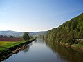
Near Creuzburg

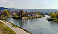
At Treffurt

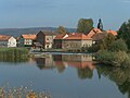
At Eschwege in autumn

Frozen Werra near Eschwege
Near Werleshausen
Confluence of the Werra (left) and Fulda (right) to the Weser (front)


Weserstein and Weserliedanlage

At the confluence of the Werra and Fulda, through the Hann. Münden the Weser arises, the (old) Weserstein has stood since 1899 and the (new) Weserstein since 2000. The Weserliedanlage is located high above the city on the other side of the Werra over the B 80 on the Questenberg .
The (old) Weserstein bears this widely known inscription:
- Where Werra and Fulda kiss
- They have to pay for their names
- And here arises from this kiss
- German to the sea of the Weser river.
Catchment area and tributaries
The catchment area of the Werra covers 5,497 km².

Both source streams and all tributaries from 30 km² catchment area are listed below.
If the catchment area and runoff do not correspond to the entire river, but only to its lowest level (rivers with estuaries in Thuringia), this is noted by footnote on the river name.
| Surname | page | Length (km) |
EZG (km²) |
Discharge ( MQ ; l / s) |
Mouth height (m above sea level ) |
Estuarine place (in) |
DGKZ |
|---|---|---|---|---|---|---|---|
| Werra (right source stream) | right | 8th | 10.7 | 491 | Schwarzenbrunn | 41-11 | |
| Saar (left source stream) | Left | 6.5 | 12.8 | 491 | Schwarzenbrunn | 41-12 | |
| Schwaba | right | 9.1 | 32.5 | 396 | Harras | 41-138 | |
| Habergrund | Left | 10.0 | 37.0 | 385 | Veilsdorf | 41-14 | |
| lock | right | 34.2 | 282.9 | 4460 | 333 | Veßra Monastery | 41-16 |
| hazel | right | 26.4 | 330.9 | 4620 | 295 | Einhausen | 41-2 |
| Jüchse (Parthe) | Left | 14.5 | 106.1 | 293 | Ober Maßfeld-Grimmenthal | 41-32 | |
| brawn | Left | 12.4 | 52.1 | 292 | Undersize field | 41-332 | |
| Herpf | Left | 21.7 | 95.3 | 277 | Walldorf | 41-34 | |
| Katza | Left | 15.1 | 61.3 | 269 | Wasungen | 41-354 | |
| Schwarzbach | Left | 11.1 | 39.5 | 264 | above. Schwallungens | 41-356 | |
| Schmalkalde | right | 24.9 | 156.4 | 2140 | 252 | Niedermalkalden | 41-36 |
| Rosabach | Left | 13.0 | 39.7 | 251 | Wernshausen | 41-372 | |
| Truse | right | 18.4 | 46.2 | 245 | Spreads | 41-374 | |
| Fischgraben (Moorbach) | right | 10.3 | 32.1 | 240 | Barchfeld | 41-376 | |
| Pfitzbach (Polsambach) | Left | 12.3 | 34.4 | 239 | bad Salzungen | 41-378 | |
| Felda | Left | 42.2 | 216.7 | 2300 | 225 | Dorndorf | 41-38 |
| Ox | Left | 16.0 | 61.6 | 223 | Vacha | 41-394 | |
| Ulster | Left | 57.2 | 421.0 | 5279 | 221 | Philippsthal | 41-4 |
| Herfabach | Left | 11.3 | 40.0 | 245 | 216 | Wölfershausen | 41-52 |
| Suhl | right | 21.8 | 91.3 | 206 | Berka | 41-54 | |
| Consecration | Left | 11.5 | 64.0 | 344 | 206 | Lower chair | 41-56 |
| Elte | right | 23.5 | 81.0 | 200 | Leek rotting | 41-58 | |
| Hörsel | right | 55.2 | 784.0 | 6260 | 194 | Hörschel | 41-6 |
| Ifta | Left | 8.9 | 30.7 | 190 | Creuzburg | 41-72 | |
| Lauterbach | right | 9.4 | 42.4 | 184 | Mihla | 41-734 | |
| Lempertsbach (Grundbach) | right | 9.0 | 30.3 | 182 | Oberh. Ebenshausen | 41-736 | |
| Frieda | right | 18.4 | 171.8 | 1339 | 161 | Frieda | 41-78 |
| Weirs | Left | 36.4 | 451.7 | 4147 | 153 | Jestädt | 41-8 |
| Berka | Left | 9.8 | 37.3 | 363 | 153 | Nonsense | 41-92 |
| Walse | right | 11.3 | 31.9 | 144 | Wahlhausen | 41-94 | |
| Gelster | Left | 23.0 | 60.6 | 771 | 132 | Witzenhausen | 41-96 |
Localities
Seen downstream on the Werra are these villages:
Water flow


Despite its greater length, the Werra has a little less water than the Fulda, which has the larger catchment area. However, the situation is similar to that at the confluence of the Rhine and Aare rivers . The latter takes in two stately tributaries shortly before its confluence, namely the Reuss and the Limmat , and only carries a little more water than the Rhine on its last kilometers. The Fulda also only reaches its stately size shortly before its confluence with the Werra, when it receives its largest tributary above Kassel with the Eder , which even exceeds the Fulda in terms of water flow here.
The Werra can have an annual mean discharge of 51.2 m³ / s, measured at the "Last Heller" gauge shortly before Hann. Münden. In 64 years between 1941 and 2005, the survey period was two years of failure (calendar year 2001, outflow year 2002, i.e. November 1, 2001 to October 31, 2002). The lowest discharge was measured on November 2, 1949 with 5.1 m³ / s. The highest measured values are quite a long time ago: on February 10, 1946, 605 m³ / s flowed off, on March 16, 1947 563 m³ / s and on March 20, 1942 528 m³ / s. A recent value only follows in seventh place: 440 m³ / s was reached on January 5, 2003.
→ See also: Werra flood 1909
Well-known bridges
- Georgsbrücke (Meiningen) , the oldest still standing reinforced concrete bridge in Germany from 1899
- Werra Bridge Vacha , medieval stone arch bridge with a total of 14 arches
- Werra Bridge Creuzburg , stone arch bridge with 7 semicircular arches from 1223
- Werratalbrücke Hörschel , 13-span prestressed concrete viaduct on federal motorway 4 , 732 m long
- Werratalbrücken Hedemünden , two parallel valley bridges for the A 7 and the high-speed railway line Hanover – Würzburg
- Old Werra Bridge in Hann. Münden , stone arch bridge from the 13th century
Economic use
Potash mining and Werra salinization

The Werra is the industrial river most heavily contaminated with salt in Central Europe today, a consequence of the mining of salts in its catchment area. Salt was already being mined here in the period before 1900, with only minor and locally limited effects on the water. For about 100 years, however, potash salts have been industrially mined on the middle and lower reaches , the mines are in the federal states of Thuringia and Hesse. Potash salts ( KCl and MgSO 4 ) are basic materials for the fertilizer industry and are in demand worldwide. They occur in nature together with other soluble salts and sparingly soluble minerals, because during the evaporation of seawater, which historically forms the deposits, all the salts contained are separated in the order from the poorly to the easily soluble salts. However, only the two salts mentioned are of interest for the production of fertilizers, all the remaining salt is waste and is disposed of in three ways: by dumping, by dumping underground in the dolomite plate and by discharging dissolved waste salt into the Werra. Part of the river's salt load comes from natural leaching , the larger part is discharged, currently at Unterbreizbach (Ulster), Dorndorf (Werra) and Heringen (Werra) . This artificial discharge only began with the industrial use of the deposits. Already at the beginning of the 20th century it endangered the drinking water supply of places lying downstream, for example the city of Bremen , whereupon the state of Bremen led a legal dispute against the states of Prussia , Thuringia and Braunschweig before the State Court for the German Empire in the 1920s .
Thereafter, limit values were set for the salinity in the Werra so that the city of Bremen could hold water that was almost of drinking water quality. The limit values for the salt load of the Werra were repeatedly relaxed until 1942, at that time 2500 mg / l chloride could not be exceeded at the Gerstungen gauge. However, in the following years this limit value was not complied with either, which was mainly due to the fact that in the 1960s the GDR stopped shipments underground and discharged all residues from potash processing into the Werra, with catastrophic consequences. The most significant pollutant was and is dissolved sodium chloride . In addition, there are other cations such as calcium , magnesium and potassium that is not completely separated, as well as anions such as sulfate . This strong salinization almost completely destroyed the freshwater ecosystem. The invertebrate fauna was naturally reduced from around 60 to 100 species to a biocenosis of 3 species. As the basis of the food pyramid in the Werra remained an introduced New Zealand screw ( Potamopyrgus antipodarum ), a freshwater shrimp ( Gammarus tigrinus ) provided in the brackish water is located, and in 1952, specifically incorporated into the salified Werra and a Strudelwurm . Through adaptation, a habitat developed in the Werra that is more like a saltwater than a freshwater ecosystem.
After German reunification, potash mining in Thuringia declined and the river recovered without, however, reaching the quality of a body of water that was not contaminated with salt. In recent years' investigations, ten species have now been found instead of three. In contrast, sections of the Werra that are not exposed to salt provide a habitat for thirty to forty species.
The Kassel mining -Unternehmen K + S AG since Pentecost 2007 also heads salt-contaminated wastewater from the waste dump of the mine Neuhof-Ellers At the Fulda into the Werra. The additional salt discharge is still within the legal limits, according to a company spokeswoman. Environmentalists criticize the additional salt input that flows into the Weser via the Werra. On the initiative of the states of Hesse and Thuringia and the company K + S AG, the round table "Water protection Werra / Weser and potash production" was set up on March 18, 2008 . He is supposed to work out a solution to the problem of Werra salinization. Since 6 million cubic meters (m³) have so far been sunk into deep geological layers, but the licensing authorities have announced a ban on this disposal route, its whereabouts must also be resolved, not just the amount that has been directed into the Werra so far.
25 representatives (federal states, municipalities, cities and districts on Werra and Weser, environmental associations, citizens' initiatives, trade unions, Weserbund , IHK, K + S AG) sit at the round table . Hans Brinckmann , former President of the University of Kassel, is in charge . A concept for a solution should be presented by autumn 2009, before which all conceivable measures should be examined for their feasibility and effectiveness. In addition to changes in production that could avoid or reduce the accumulation of salt to be disposed of, better disposal routes should also be considered, for example by direct discharge into the North Sea via a pipeline, underground backfilling and the evaporation of the waste liquors on site. The latter is not feasible from the company's point of view. The pipeline to the North Sea met with resistance from politicians from Hesse, North Rhine-Westphalia and above all from Lower Saxony, which would have to grant permission under water law for the discharge into the North Sea. In September 2014, the Hessian Ministry for the Environment, Climate Protection, Agriculture and Consumer Protection presented a study according to which the requirement for the construction and operation of the sewer pipeline was not economically justifiable and therefore disproportionate. On November 30, 2012, the Kassel regional council granted K + S a new water law permit for the discharge of saline wastewater into the Werra. In the permit, the wastewater quantities and parameters are to be gradually reduced by 2020. Among other things, the limit value for chloride, which has remained unchanged since 1942, is to be reduced to 1,700 mg / l from 2015 and the amount of waste water to eight million cubic meters per year. Even with the stricter limit values, critics see it as impossible to achieve the quality goals of the EU Water Framework Directive by 2020. One solution to the problem could be to temporarily store the salty wastewater in old, deep-seated mine structures. This process, known as "stacking", is intended to enable K + S to largely maintain its operation, even when the river has little water flow, without exceeding the limit values. The groundwater is not endangered because the pits are under the aquifers.
shipping
_in_Wanfried.jpg)

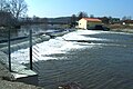
The Werra (Wr) is an unclassified federal waterway in its estuary from km 89.0 (confluence with the Weser) to 84.0 (barrage "Last Heller") , from there to km 0.78 (barrage Falken) a so-called . " Other inland waterways of the federal government ", for which the waterways and shipping office Hann. Münden is responsible. Today there are 7 barrages on this route in Falken, Wanfried, Eschwege, Bad Sooden-Allendorf, Hedemünden, “Last Heller” and in Hann. Münden primarily for the use of hydropower. To maintain navigability there are in Eschwege, Bad Sooden-Allendorf and Hann. A small chamber lock each opening; the lock "Last Heller" is out of order. The Werra is only used by sport shipping.
Already in the early Middle Ages, monasteries gave impetus for a Werra shipping. In the 14th century, when the mill was installed, shipping above Wanfried came to a standstill. Below Wanfried, the windmills were so low that the ships could use open ship lanes, which were also raft lanes, or locks. In practice there was only one boat trip to the valley, the light boats were sold in Münden. Were promoted u. a. Woad, a plant used to make blue paint, and ceramics because of cheap and unbreakable transportation, and large quantities of grain for Holland.
Numerous plans from the 17th century to use the Werra again above Wanfried and even to establish a connection to the Main through a Main-Werra Canal were finally abandoned in 1961. But to enable the ascent, Landgrave Wilhelm VIII of Hessen-Kassel had locks built at the mills in Eschwege (1735) and (Bad Sooden-) Allendorf (1756). The construction of the Hann barrage served to remove a centuries-old obstacle to shipping, a rock bar. Münden 1877–1881 with a needle weir and a chamber lock. The hoped-for upswing in freight shipping did not materialize and was completely discontinued with the First World War.
Between 1921 and 1924, the barrage on the “Last Heller” was built to generate hydropower. From 1926 there were new plans for an expansion of the Werra, primarily for the transport of potash to the Bremen overseas port. The Second World War finally prevented the realization.
Locks
The Werra locks (see also the shipping section above ) are (viewed downstream):
| Name of the lock | Kilometers of waterways | Data | Construction year |
|---|---|---|---|
| Wanfried lock | Wr 20.2 | L 21 m / W 4.30 m / drop height 2.10 m | 1752 |
| Eschwege lock | Wr 29.406 | L 32 m / W 4.60 m / drop height 2.25 m | 1752 |
| Bad Sooden-Allendorf lock | Wr 47.655 | L 38 m / W 4.40 m / fall height 2.36 m | 1752 |
| Lock Last Heller | Wr 83.943 | L 40 m / W 4.50 m / drop height 4.80 m | 1923 |
| Werraschleuse Hann. Münden | Wr 88.6 | L 85 m / W 10.00 m / drop height 13.30 m | 1881 |
rafting
On the Werra, rafts were brought down the river from the Thuringian Forest since the 16th century; the last ones came into the river in 1939. The Thuringian rafts , the so-called Oberlanders, were 18–20 m long, 3.30–4 m wide, their content was around 20 solid cubic meters of wood. The rafting was hindered by the fact that the Werra was in places the border river between Saxony-Meiningen and Hesse. Frequent disputes concerned the raft timber levy, bank damage and occasional theft, as well as the opening times of the mill weirs. From 1567 onwards, Hesse was only allowed to bring raft wood to Sooden-Allendorf on the Werra free of duty and escort. However, this wood should only be thrown in between May 1st and Pentecost or Laurentius Day. The officials in Creuzburg and Gerstungen had to be informed 14 days in advance when and where the wood was to be thrown in. As compensation for the damage done, the saltworks in Sooden had to deliver 100 eighths of salt to the Duke of Saxony-Eisenach every year. The wood destined for Sooden-Allendorf came from the areas of the central Werra below Bad Salzungen. The offices of Gerstungen and Kreuzburg were named in the ordinances. Above all, the Seulingswald supplied raft wood. In Sooden there was a mobile rake that was only pulled into the river for the duration of the rafts. On arrival, the wood was removed by the wood bailiff , who assessed it and sold it to the master saddlers. The money raised was used to reward the woodcutters, carters and raftmen. The modest size of the Werra rafts was due to the shallow fairway and the narrow raft lanes next to the weirs. The actual Werra rafting started in Wernshausen, a centuries-old rafting center in the Thuringian Forest. Located directly on the Werra, the main stacking and binding area was located in front of the village, the incoming wood was stored here according to strength classes, sorted and the trunks were prepared for binding by carpenters. Since the 17th century, the Wilhelmsglücksbrunn salt works in Creuzburg has also been dependent on the transport of raft timber. After the salt pans, the cities destroyed after the Thirty Years' War were also dependent on timber deliveries, which were supplied in the form of prefabricated beams and floorboards. Even today, the wooden head house in Mihla is reminiscent of a once wealthy Thuringian rafting family, who were allowed to continue their rafts towards Bremen.
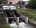
Werra power plants
Current hydropower plants on the Werra include:
| place | Power [MW] | operator | in operation since |
|---|---|---|---|
| "Walkmühle" hydropower plant in Meiningen | Retzer company | 2009 | |
| Tiefenort hydropower plant | ??? | ??? | |
| Dorndorf hydropower plant | East-west hydropower plants | 1996 | |
| Heringen hydropower plant | Eberlein GmbH | 1904/2005 | |
| Berka / Werra hydroelectric power station | ??? | ??? | |
| "Steinmühle" hydroelectric power station, Wommen | ??? | ??? | |
| Spichra hydropower plant | Thuringian energy | 1925 (1998) | |
| Mihla hydropower plant | Thuringian energy | 1919 (2006) | |
| Falken hydroelectric power station | Thuringian energy | 1912 (1999) | |
| Wanfried power station | from Scharfenberg KG | 1901 | |
| Castle mill / Schabe Eschwege | City of Eschwege | 1906/1908 | |
| Bad Sooden-Allendorf hydropower plant | Werra power plant Bad Sooden-Allendorf | ??? | |
| Hedemünden run-of-river power plant | 0.18 | August Hannemann (WKA) | 1963 (2013) |
| Hann. Münden, run-of-river power plant Werrawerk (formerly "Last Heller") | 2.60 | Statkraft Markets GmbH | 1924 |
| Hann. Münden, Blumer Weir hydropower screw | 0.14 | Utilities Hann. Münden | 2011 |
There used to be plants in Bad Salzungen, Vacha and Sallmannshausen.

Berka / Werra hydroelectric power station

Spichra hydropower plant
Mihla hydropower plant
Sallmannshausen hydropower plant

Schabe hydroelectric power station, Eschwege
Run-of-river power station Werrawerk, Hann. Münden
Double hydropower screw, Hann. Münden


Fishing
The Werra was still one of the most important fishing areas in Thuringia in the Middle Ages. The fishing rights were partially granted by the sovereign to privileged millers or noble landlords. The dispute over catch quotas and the installation of fish weirs fills volumes. Salmon were detectable in the Werra until the 18th century . With the introduction of untreated industrial wastewater and the residues from potash and soda production, the river's fish population deteriorated dramatically. The fish populations still present in the tributaries also suffer from municipal and agricultural sewage and the installation of weirs.
tourism


The 290 km long, supra-regional and uniformly marked Werra Valley Cycle Path has been running alongside the Werra since 1997 . The river itself is heavily frequented by water hikers. Boat rentals exist at several locations on the Werra. The water hiking route is accessible with boat moorings and porters as well as snack bars with information boards on weir systems from Themar in southern Thuringia to the mouth of the Weser.
From Hann. From Münden to the Wartburg near Eisenach , the Werra-Burgen-Steig long-distance hiking trail (X5) accompanies the river with a Thuringian and Hessian route, the Werra-Burgen-Steig Hessen (X5H) certified by the Association of German Mountain and Hiking Clubs.
research
Thuringia
The investigation programs for water monitoring in the Thuringian State Institute for Environment and Geology include water biology and water chemistry. The species spectrum of the tributaries in Thuringia was recorded for the first time in 2006 and for comparison last in 2010. A central fish database is being set up as a monitor for water quality, and the annual data is to be incorporated into this. Data that nature conservation associations themselves collect should also be taken into account. The result of the current investigation was announced in June 2011: It shows a significant deterioration in fish stocks as an indication of a deterioration in the quality of the river Werra and its main tributaries Nesse and Hörsel in the Wartburg district and in the independent city of Eisenach.
Historical flood events
Every year floods cause enormous damage along the rivers. In order to protect people and property, the risk of a flood disaster must be determined, protective measures and operational plans must be organized. For this purpose, historical flood events must be taken into account. Their occurrence has been documented for centuries in local chronicles and, for example, by markings on buildings. The scientific documentation and evaluation of historical flood events is carried out by a research group at the University of Göttingen for the river basin of the Weser.
beaver
The beaver has also been spreading again on the Werra and some of its tributaries in southern and western Thuringia since 2012. The Thuringian State Office of Administration as Upper conservation authority has called for this in cooperation with the Society for Nature Conservation (NABU) National Association of Thuringia, the project "beaver management in Thuringia 2013/2014" to life. In the years that followed, beaver and beaver tracks were found on several sections of the Werra as far as Bad Sooden-Allendorf in Hesse .
See also
literature
- Fritz Kühnlenz: Experiences on the Werra. Local history walks. Greifenverlag , Rudolstadt 1973.
- Werraland - Merian issue No. 33 , Hamburg: Hoffmann and Campe (special issue) 1980, 96 pages, illustrations and maps
- Caspar Heinrich Schwendt: Nine four-color reproductions of selected paintings (of the city of Eschwege and its surroundings in the format 42 × 30 cm with an introduction and explanations by Klaus Meier-Schomburg), Verlag Peter Kluthe, Eschwege 1976
- Ernst Christopher Metz : Romance in the Werra Valley . With a board of text and introductory explanations as well as nine large-format, colored picture boards (format 43.5 × 30.5 cm) of the city of Eschwege and its surroundings. Verlag A. Roßbach, Eschwege 1986
- Werratal Journal - From the Werra springs to Hannoversch Münden. Bad Salzungen and Eisenach: 1996–1998 (Issues No. 1–3), No. 4 (approx. 1999)
- Manfred Lückert : The Werra. Landscape and life on the river between the Thuringian Forest and Hann. Münden., Verlag Rockstuhl , Bad Langensalza , 2nd edition 2007. ISBN 978-3-938997-26-0
Web links
- Map / aerial photo of the complete Werra / Placemarks river system ( Google Earth required)
- Literature about Werra in the Hessian Bibliography
- Map of the longitudinal sections of the watercourse , in water , on tlug-jena.de (PDF, 1.23 MB)
References and comments
- ↑ a b c d e Map services of the Federal Agency for Nature Conservation ( information )
- ↑ a b Measurement via geopath (kmz, 66 kB). The values of 292.1 km (without source streams) and 298.7 km (above the source on Eselsberg) have been corrected upwards by 0.9 km, since according to the Hessian station the Ulster estuary is at 161.6 km, but in the geoppath it is at km 160.7.
- ↑ a b c Thuringian State Agency for the Environment (ed.): Area and waterway key figures directory and map. Jena 1998; 26 pp.
- ^ German Hydrological Yearbook Weser-Ems 2014. Lower Saxony State Agency for Water Management, Coastal and Nature Conservation, p. 100, accessed on October 4, 2017 (PDF, German, 8805 kB).
- ^ German Hydrological Yearbook Weser-Ems 2014. Lower Saxony State Agency for Water Management, Coastal Protection and Nature Conservation, p. 102, accessed on October 4, 2017 (PDF, German, 8805 kB).
- ^ German Hydrological Yearbook Weser-Ems 2014. Lower Saxony State Agency for Water Management, Coastal and Nature Conservation, p. 103, accessed on October 4, 2017 (PDF, German, 8805 kB).
- ^ German Hydrological Yearbook Weser-Ems 2014. Lower Saxony State Agency for Water Management, Coastal Protection and Nature Conservation, p. 108, accessed on October 4, 2017 (PDF, German, 8805 kB).
- ↑ a b c Lengths (in km) of the main shipping routes (main routes and certain secondary routes) of the federal inland waterways ( memento of the original from January 21, 2016 in the Internet Archive ) Info: The archive link was automatically inserted and not yet checked. Please check the original and archive link according to the instructions and then remove this notice. , Federal Waterways and Shipping Administration
- ↑ See section in article of lock .
- ↑ a b c Water map service of the Hessian Ministry for the Environment, Climate Protection, Agriculture and Consumer Protection ( information )
- ^ German Hydrological Yearbook Weser-Ems 2014. Lower Saxony State Agency for Water Management, Coastal Protection and Nature Conservation, accessed on October 4, 2017 (PDF, German, 8805 kB).
- ↑ For a better overview and sorting downstream, a hyphen has been inserted for each river in the water body code (DGKZ) after the number "41", which stands for the Werra .
- ↑ Discharge at the Rappelsdorf gauge (catchment area 256 km², 9 km above the mouth)
- ↑ Discharge at the Ellingshausen gauge (327 km² catchment area), 4 km above the mouth
- ↑ The length of the Hasel over the Lauter is 32.5 km, that over the Schwarza even 38.1 km.
- ↑ Discharge at the Mittelschmalkalden gauge (153.0 km² catchment area), 3 km above the mouth
- ↑ Discharge at the Mittelschmalkalden gauge (catchment area: 214 km²), 2 km above the mouth
- ↑ Runoff at the Eisenach-Petersberg gauge (10.6 km above the mouth) plus the Nesse runoff at the Eisenach-Nessemühle gauge (0.3 km above the mouth in the Hörsel) - a total of 731.3 km² catchment area
- ↑ The district of Wanfried- Heldra (ESW / HE) is located between individual districts of Treffurt (WAK / TH).
- ↑ Environmental pollution by K + S - The dark side of the stock market star , from July 27, 2012, on spiegel.de
- ↑ Gunkel: Salt in the soup. 2006.
- ↑ Hübner, Gerd: Ecological and faunistic river assessment using the example of the salt-laden lower Werra and selected tributaries. Ecology and environmental protection 27 (2007) Editor: University of Kassel
- ^ Institute for Freshwater Ecology and Fishery Biology Jena: The ecological condition of the macrozoobenthos of the middle and lower Werra and its main influencing factors. Expert opinion, April 2009
- ↑ Werra Round Table ( Memento of the original dated February 7, 2013 in the Internet Archive ) Info: The archive link was inserted automatically and has not yet been checked. Please check the original and archive link according to the instructions and then remove this notice.
- ↑ Potash plant not feasible without wastewater In: HNA. accessed on September 24, 2014.
- ↑ Salt should stay where it is In: Mindener Tageblatt. accessed on September 24, 2014.
- ↑ Hessen no longer wants a potash pipeline In: HNA. accessed on September 24, 2014.
- ↑ The new limit values. Statement by the Werra-Weser Neighboring Conference e. V. on the discharge permit of November 30, 2012 Press release of the Werra-Weser neighbors conference, December 6, 2012, accessed on January 23, 2014 (PDF).
- ↑ https://www.hersfelder-zeitung.de/lokales/philippsthal-heringen/philippsthal-ort473874/pipeline-neue-lagermoeglichkeit-salzabwaesser-12913796.html
- ↑ Directory E, serial no. 62 and directory F der Chronik ( Memento of the original of July 22, 2016 in the Internet Archive ) Info: The archive link has been inserted automatically and has not yet been checked. Please check the original and archive link according to the instructions and then remove this notice. , Federal Waterways and Shipping Administration
- ↑ Hans Joachim Bodenbach: A sperm whale tooth from the Werra, in: Das Werraland, Eschwege 38th year, issue 4, December 1986, pp. 58–59
- ↑ Directory of the locks in Weser, Werra and Fulda ( Memento of the original from April 7, 2014 in the Internet Archive ) Info: The archive link was automatically inserted and not yet checked. Please check the original and archive link according to the instructions and then remove this notice. . Accessed April 2, 2014
- ↑ Manfred Lückert : The Deelenflößer come In: The Werra. Landscape and life on the river between the Thuringian Forest and Hann. Münden ., Verlag Rockstuhl , Bad Langensalza , 2nd edition 2007. ISBN 978-3-938997-26-0
- ↑ History of the Wanfried Electricity Works ( Memento of the original from April 1, 2016 in the Internet Archive ) Info: The archive link has been inserted automatically and has not yet been checked. Please check the original and archive link according to the instructions and then remove this notice.
- ↑ Helmut Krischmann: New turbine is created . The Hannemann brothers expand a hydropower plant on the Werra. In: HNA Mündener Allgemeine . July 24, 2013, p. 2 .
- ↑ Norman Meißner, Sascha Willms: Fish fauna in the Wartburg district gives cause for concern . Ed .: Thüringische Landeszeitung. Local website Eisenach June 15, 2011.
- ↑ M. Deutsch, K.-H. Pörtge: high water marks in Thuringia . Ed .: Thuringian Ministry of Agriculture, Forests, Environment and Nature Conservation. Erfurt and Göttingen 2009, Weser river basin.
- ↑ NABU Thuringia , accessed on February 11, 2014
- ↑ Stefan Forbert: The beaver is spreading: There are activities in five sections of the Werra. In: Hessian Lower Saxony General. April 15, 2020, accessed April 15, 2020 .