Lempertsbach
|
Lempersbach (Unterlauf also: Grundbach ) |
||
|
At the Lempersbach in Nazza |
||
| Data | ||
| Water code | DE : 41736 | |
| location | Thuringia , Germany | |
| River system | Weser | |
| Drain over | Werra → Weser → North Sea | |
| source | Outskirts of Heyerode 51 ° 9 ′ 31 ″ N , 10 ° 19 ′ 16 ″ E |
|
| Source height | approx. 330 m above sea level NN | |
| muzzle | At Mihla coordinates: 51 ° 5 '14 " N , 10 ° 19' 37" E 51 ° 5 '14 " N , 10 ° 19' 37" E |
|
| Mouth height | 182.3 m above sea level NN | |
| Height difference | approx. 147.7 m | |
| Bottom slope | approx. 16 ‰ | |
| length | 9 km | |
| Catchment area | 30.3 km² | |
| Left tributaries | Ritzhäuser Wasser (1.6 km), Ludenborn (1.0 km), Steingraben (1.9 km) | |
| Right tributaries | Bärenbach (1.9 km), Griebelsgraben (1.1 km), (unnamed) right tributary of Nazza (2.2 km) | |
| Communities | Heyerode , Hallungen , Nazza , Mihla | |
|
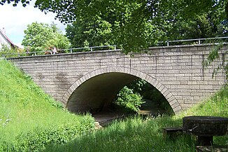
The Lempersbach Bridge in Nazza |
||
The Lempersbach , also called Grundbach in the lower reaches , is a 9 km long, orographically right tributary of the Werra in Thuringia , Germany , which flows almost continuously in a southerly direction. The original name of the water is said to have been Nazzaha , from which the place name Nazza was derived.
course
The Lempersbach rises in a meadow on the southern outskirts of Heyerode . There is a small pond only 200 m from the spring, which is fed by strong pouring springs. From this reservoir the Mühlwasser was a wooden trough for 300 m creek downstream Obermuhle transported to an overshot water wheel. Heyerode also includes the lower mill, which follows after another 200 m and was supplied with water in the same way.
The Lempersbach now has to squeeze through a natural bottleneck between Sommerstein (left side = east, 462 m) and Aschberg (422 m) or Ruppersberg (372 m) and receives its first tributary, the Bärenbach , between the last two mountains mentioned . As far as the outskirts of Hallungen, the Ritzhäuser Wasser follow as the left tributary and the Griebelsgraben as the right tributary. To the southeast of the 347 m high Rohrbachskopf , the Lempersbach is dammed in two fish ponds between the mouths of the last two tributaries mentioned.
This is followed by the location of Hallungen , which extends over a length of 500 m on the western bank. After another 500 m the Ludenborn joins from the left. To the west of the 313 m high Knoblochsköpfchen a fish farm was built, it consists of 7 small ponds.
This is followed by the location of Nazza , here the Lempersbach is channeled through the location as a canalised watercourse. A nameless right tributary flows into the far north of the place and the stone ditch that rises near Wernershausen as a left tributary flows into the south of Nazza.
Up to the confluence with the Werra below Mihla , the Lempersbach flows through an approximately 3 km long, partially wooded and very narrow valley. The former small settlement Almenhausen was located here - today a deserted area to which the Grundmühle , which was demolished in 1985, also belonged.
Surname
The name of the river Lempersbach goes back to an old fortification - Landwehr , which cuts the brook at the church head near Nazza. The name Grundbach is common in the lower reaches, the Grundmühle was also located here . In the map collection of JG Schleenstein this brook is marked with the Natze .
Economic history
Several mills were operated with the water of the Lempersbach as early as the High Middle Ages , including the upper mill and the lower mill near Heyerode and the basic mill near Mihla. Numerous fish ponds can still be found around Hallungen today. In Nazza there was also a flax roast at times below the locality .
Web links
literature
- Raymund Falk: The desert of Reichensachsen near Heyerode and the settlement of the Hainich low mountain range . In: Association for Eichsfeldische Heimatkunde (Hrsg.): Eichsfeld-Jahrbuch . Issue 1. Mecke Druck und Verlag, Duderstadt 1993, p. 127-160 .
- Rainer Lämmerhirt : Mihla. From the story of a village in West Thuringia . Heimat- und Verkehrsverein, Mihla 1993 ( West Thuringian Heimatschriften special volume, ZDB -ID 2285013-2 ).
Individual evidence
- ↑ a b Topographic map 1: 25,000
- ↑ a b c River lengths according to geopaths (kmz, 7 kB)
- ↑ Measured over the Bärenbach, the Lempersbach is about 10.1 km long.
- ^ Thuringian State Institute for the Environment (ed.): Area and waterway key figures (directory and map). Jena 1998. 26 pp.
- ↑ The stream is significantly longer over the wet and dry Ludenborn , which only carries water temporarily
- ^ Volker Große, Klaus Herzberg: Obermühle / Untermühle Heyerode . In: Maik Pinkert (Ed.): Mühlen im Obereichsfeld. A compendium . Eichsfeld-Verlag, Heiligenstadt 2008, ISBN 978-3-935782-13-5 , p. 180-182 .

