
Wartburg district
| coat of arms | Germany map |
|---|---|

|

Coordinates: 50 ° 53 ' N , 10 ° 13' E |
| Basic data | |
| State : | Thuringia |
| Administrative headquarters : | bad Salzungen |
| Area : | 1,267.26 km 2 |
| Residents: | 118,974 (Dec. 31, 2019) |
| Population density : | 94 inhabitants per km 2 |
| License plate : | WAK, SLZ |
| Circle key : | 16 0 63 |
| NUTS : | DEG0P |
| Circle structure: | 32 municipalities |
| Address of the district administration: |
Erzberger Allee 14 36433 Bad Salzungen |
| Website : | |
| District Administrator : | Reinhard Krebs ( CDU ) |
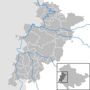
| Location of the Wartburg district in Thuringia | |
  |
|
The Wartburgkreis is a district in Thuringia . With 1267.26 km² it is the largest district in the Free State in terms of area . The district town is Bad Salzungen . The Wartburg, which gave the district its name, has no longer been part of the district since the spin-off of the now independent city of Eisenach in 1998. The district extends along the central reaches of the Werra and the Hessian-Thuringian border. It almost completely encloses the independent city of Eisenach. In terms of spatial planning , the district belongs to the Southwest Thuringia planning region and is a member of the Southwest Thuringia planning community .
geography
Location in Thuringia
The Wartburg district is located in the west of Thuringia . Neighboring districts are the Unstrut-Hainich district in the north, the district of Gotha in the east, the district of Schmalkalden-Meiningen in the southeast , the Hessian district of Fulda in the south and southwest and the Hessian districts of Hersfeld-Rotenburg and Werra-Meißner district in the west . The independent city of Eisenach protrudes in the north from west to east into the district area.
Natural structure
The southwest of the Wartburg district belongs to the low mountain range of the Rhön . The western Thuringian Forest , the Werra Valley and the Hainich are proportionally part of the district area.
The Wartburg district is partly in the Hainich National Park (3,074 ha, 2.3% of the total area), in the Rhön Biosphere Reserve (27,382 ha, 21.0%), in the Thuringian Rhön landscape protection area (31,515 ha, 24.2%), in the Thuringian Forest landscape protection area (11,900 ha, 9.1%), in the Thuringian Forest Nature Park and in the Eichsfeld-Hainich-Werratal Nature Park .
Protected areas
There are 46 designated nature reserves , 54 area natural monuments and 95 natural monuments in the district . In addition, around 10,000 specially protected biotopes within the meaning of the Federal Nature Conservation Act are mapped with an area of around 6,650 ha.
Mountains and elevations


The elevation of the terrain in the Wartburg district is between 169 m in the Werra valley below Großburschla and approx. 740 m on the Rennsteig between Ruhla and Steinbach. The Gerberstein in the Thuringian Forest is the highest point in the Wartburg district.
Rhön and Salzunger Werrabergland
- Sachsenburg (720.9 m), Auersberger Kuppenrhön
- Baier (713.9 m), Auersberger Kuppenrhön
- Glassesberg (670 m), Auersberger Kuppenrhön
- Dietrichsberg (668.9 m), Auersberger Kuppenrhön
- Pleß (645.4 m), Vordere Rhön / Salzunger Werrabergland
- Öchsenberg (627.2 m), Auersberger Kuppenrhön
- Stoffelskuppe (620.1 m), Vordere Rhön / Salzunger Werrabergland
Thuringian Forest
- Großer Weißenberg (746.5 m) near Steinbach and Brotterode
- Rennwegskopf (729.6 m) near Steinbach and Brotterode
- Gerberstein (728.5 m) near Ruhla and Steinbach,
- Birkenheide (717.3 m)
- Glöckner (702.5 m), near Ruhla
- Breitenberg (697.3 m)
- Kahle Koppe (690.1 m)
- Bommelhauck (684.7 m)
- Schnepfenberg (677.4 m)
- Kissel (648.8 m)
- Höllkopf (646.0 m)
Hainich and Ringgau
- Heldrastein (503 m)
- Old Mountain (493.9 m)
- Stöckigtsberg (450.2 m)
- Linden hedge (447 m)
- Rittergasserberg (440.3 m)
- Wartenberg (429.9 m)
- Harsberg (409.7 m)
- Goldberg (379.8 m)
- Adolfsburg (378.7 m)
Waters
The district has 1326 hectares of water.
Flowing waters


All of the surface water that occurs is discharged to the Weser and North Sea via the Werra . The entire circuit area is thus according to the Water Act of RBD Weser assigned.
The Wartburgkreis has the largest share of the central reaches of the Werra. Due to historical demarcations since the Middle Ages, the Werra in the section between Vacha and Großburschla forms the state border between Hesse and Thuringia several times.
In the following, all rivers of the first order are listed according to the classification according to Appendix 1 of the Thuringian Water Act and the most important waters of the second order; 1st order waters are shown in bold:
| Rivers in the Wartburg district |
Total length in km |
of which in the district area |
|---|---|---|
| Werra | 299.6 | |
| Elte | 22.5 | 22.5 |
| Emse | 14th | |
| Hereditary current | 13.5 | 13.5 |
| Felda | 42.2 | |
| Grumbach | 12 | 12 |
| Hörsel | 48.5 | |
| Ifta | 5.5 | 5.5 |
| Lauterbach | 14.0 | 14.0 |
| Lempertsbach | 9.5 | 7.5 |
| Girl | 10 | 10 |
| Nesse | 52.6 | |
| Ox | 16 | 16 |
| Pfitzbach | 12.3 | 12.3 |
| Pipe donations | 7th | 7th |
| Schnellmannshaus Bach | 7.2 | 7.2 |
| Schweina | 12.5 | 12.5 |
| Suhl | 22.3 | 22.3 |
| Ulster | 57.2 |
Standing waters


The Wartburg district has only a few natural standing waters, which are mainly formed as sinkhole lakes . These include the Burgsee , the Buchensee and the Erlensee in or near Bad Salzungen, the Hautsee and the Albertsee near Dönges , the Frauensee , the Bernshäuser Kutte and the Schönsee near Urnshausen and the Forstloch near Immelborn .
The Schönsee and Kiesseen I and II of the Immelborn gravel pit are designated as bathing waters .
As early as the Middle Ages, the construction of fish ponds began, which mostly arose in the vicinity of monasteries. As a result of the gravel extraction in the Werra valley, gravel pit waters were created near Treffurt, Mihla, Gerstungen, Dankmarshausen, Vacha, Immelborn and Barchfeld.
A specialty is the Wilhelmsthaler See , it was created as a reservoir in the course of the Elte to complement the park of Wilhelmsthal Castle and originally served as a gondola pond. Built around 1715, it is considered the oldest dam in Thuringia. Other reservoirs, mostly built as irrigation reservoirs in the second half of the 20th century, are located near Ettenhausen / Suhl , Großenlupnitz, Burkhardtroda and Bairoda. An industry-related water reservoir was created in Fuchsgrund near Thal.
Backwaters of the Werra, created by river straightening, are still present at Tiefenort, Gerstungen, Pferdsdorf-Spichra and Treffurt.
Moors
As a result of leaching and subsidence processes, extensive moorland and wetland areas were formed north of Bad Salzungen and near Dankmarshausen, known as Moorgrund and Rhäden (with the Dankmarshäuser Rhäden nature reserve ). Most of these were transformed into grassland through amelioration in the 19th century. The raised bogs in the high areas of the Rhön enjoy special protection.
history

In the 19th century, the area of today's Wartburg district belonged in large parts to the Grand Duchy of Saxony-Weimar-Eisenach . A number of communities around Bad Salzungen, Bad Liebenstein, the exclaves Oberellen and Dietlas belonged to the Duchy of Saxony-Meiningen . The district of Barchfeld occupies a special position, it formed an exclave of Hessen-Kassel until 1866 and then belonged to the Kingdom of Prussia . The north-western part with Treffurt and its current districts Großburschla , Schnellmannshausen (partially) and Falken belonged to the Kingdom of Prussia, district of Mühlhausen , since 1817 . The northeastern part, the Hörselberg region and Ruhla belonged to the Duchy of Saxe-Coburg and Gotha .
After the First World War , the amalgamation of the individual states led to the establishment of the Free State of Thuringia on May 1, 1920, although the previously Prussian areas were left out.
The Thuringian government carried out the first district division in 1921. Eisenach became an independent city, the majority of today's district area formed the district of Eisenach . The town of Bad Salzungen and its neighboring towns were assigned to the district of Meiningen . The villages of Bairoda and Barchfeld belonged to the then Hessian district of Herrschaft Schmalkalden .
The founding of the GDR on October 7, 1949 led to the first administrative structural reform in 1950. The newly created Bad Salzungen district was made up of the northwestern part of the Meiningen district (Bad Salzungen and neighboring communities) and the southern part of the Eisenach district, the Eisenacher Oberland , put together. The town of Treffurt with the neighboring towns of Großburschla, Schnellmannshausen (partially) and Falken remained in the Mühlhausen district.
Another administrative reform in 1952 led to the formation of the districts of Erfurt , Gera and Suhl . In the course of this reform, the area around Behringen came to the Bad Langensalza district , the city of Treffurt and neighboring towns were transferred to the Eisenach district . From then on, the Eisenach district belonged to the Erfurt district, the Bad Salzungen district to the Suhl district. This administrative structure lasted until the district reform in Thuringia in 1994.
The Wartburgkreis was created on July 1, 1994 on the basis of the law on the reorganization of the districts and independent cities in Thuringia of August 16, 1993 by merging the Eisenach and Bad Salzungen districts and the communities of Behringen, Craula, Reichenbach, Tüngeda and Wolfsbehringen of the Bad district Langensalza.
The district office was initially located in Bad Salzungen and Eisenach. On January 1, 1998, the city of Eisenach became a district and Bad Salzungen became the sole district town.
As part of the Thuringia regional reform in 2018 and 2019 , the city of Kaltennordheim was reclassified from the Wartburg district to the Schmalkalden-Meiningen district on January 1, 2019.
Population development
Development of the population:
|
|
|
|
|
- Data source: from 1994 Thuringian State Office for Statistics - values from December 31st
- ¹ from 1998 without then city of Eisenach
politics
District council
Since the district council election on May 26, 2019 , the 50 seats in the district council have been distributed among the individual groups as follows:
| Political party | Seats | |
| CDU | 18 (−2) | |
| AfD | 8 (+8) | |
| LEFT | 7 (−2) | |
| FW WAK | 6 (+1) | |
| SPD | 4 (−5) | |
| GREEN | 3 (+1) | |
| FDP | 2 (+1) | |
| NPD | 1 (−2) | |
| LAD | 1 (± 0) |
District administrators

| Surname | from | to |
| Martin Kaspari (CDU) | 1994 | 2006 |
| Reinhard Krebs (CDU) | 2006 |
In the district elections on April 22, 2012 , Reinhard Krebs was confirmed in office in the first ballot. He was able to unite 56.4% of the valid votes. The turnout was 42.5%. In the election on April 15, 2018 , he received 71.3% of the vote.
coat of arms
Blazon : “Quartered; Field 1 in blue is a left-turned, seven-fold red-silver divided, golden armored and crowned lion, field 2 in gold on a green three-mountain a black, red armored hen with red rags and a comb; Field 3 in silver a continuous cross; Field 4 like field 1 turned right. "
The lion at the top left is shown as it was carried in the coat of arms of the Saxon branch lines Sachsen-Weimar-Eisenach , Sachsen-Meiningen and Sachsen-Coburg and Gotha . At the bottom right, however, the official version of the Thuringian family coat of arms was used. On the top right, on a green three-hill, stands a black hen with red arms and a red rag and comb in front of a gold background as the coat of arms of the county of Henneberg . The continuous black high cross of the Diocese of Fulda , which owned areas in the south of the district, is shown in front of a silver background on the lower left .
An overview of the coats of arms of the towns and communities in the district can be found in the list of coats of arms in the Wartburg district .
flag
The Wartburgkreis carries a white-red split flag, which shows the coat of arms in the middle; accordingly the banner flag is split white and red.
Economy and Infrastructure
Economy and industry
Due to the automotive location Eisenach, there are numerous industrial companies as automotive suppliers and service companies in the Wartburg district. In Creuzburg the currently largest and most modern sawmill in Europe was created. In the south-western part of the district lies the eastern part of the Werra potash district, a traditional center of the potash industry and Thuringian mining. The Merkers Mine was when it opened in 1925, the largest potash mine in the world; today carried potash mining in K + S -Werk Unterbreizbach . The spa, clinic and rehabilitation facilities in and around Bad Liebenstein , Bad Salzungen and Stadtlengsfeld are concentrated in the southern Wartburg district .
The industrial region around Ruhla with the traditional watch industry , machine tool construction, electronics production and numerous small businesses as suppliers has restructured. Centuries-old knowledge and skills of woodworking have been preserved in the Rhön and can be learned, for example, in Empfertshausen . As a biosphere reserve, the Rhön is also a center of organic agriculture and gentle tourism. The Hainich National Park is developing in a similar way in the northeast of the district .
The settlement of aviation-specific companies in the vicinity of the Eisenach-Kindel airfield is planned, which has already been achieved in some cases. In the Kindel industrial area (municipality of Hörselberg-Hainich ), important automotive suppliers and an assembly plant for heavy construction vehicles (tippers) as well as a large logistics company have also settled.
In the Future Atlas 2016 , the Wartburg district was ranked 353 out of 402 districts and urban districts in Germany, making it one of the regions with “high future risks”.

Sawmill near Creuzburg

former potash works in Merkers

Clockwork in Ruhla


Renewable energy
In the Wartburg district there are several wind priority areas with wind turbines . Several former landfills and industrial sites are used for photovoltaic systems, for example in Dietlas , near Creuzburg and on the former Bad Salzungen district garbage dump. Since the beginning of the 20th century, the Werra with its tributaries has been used in the district to generate energy. There are hydropower plants at Tiefenort, Dorndorf, Berka, Spichra, Mihla and Falken, among others. Since the beginning of 2018, resistance has been rising in the population of the surrounding areas against the planned expansion of the wind priority area on the Reitberg south of Mihla and the construction of further, larger wind turbines in the area. The establishment of a citizens' initiative is planned.

Wind energy plants on the riding mountain near Mihla

Tiefenort hydropower plant
Mihla hydropower plant


traffic
Street

The most important traffic connections are the federal highway 4 and the federal highways 7 , 19 , 62 , 84 , 88 , 250 , 278 and 285 , whereby the federal highways 19, 62, 250, 278 and 285 have their start and end point in the district area. In 2009, the district had 191.71 km of federal , 328 km of state and 175.55 km of district roads .
rail

In terms of railway technology, the Wartburg district is made accessible by the Thuringian trunk line . The Eisenach railway station is the most important station of the Wartburg circle passing by ICE and IC trains is connected to long-distance traffic. The Werra Railway also begins in Eisenach and runs via Bad Salzungen to the neighboring Schmalkalden-Meiningen district and as far as Eisfeld , and is served by the Süd-Thüringen-Bahn in regional rail transport. The railway line to Vacha , which begins at Bad Salzungen station in the district town , is only used for freight traffic. The railway line formerly leading from Gerstungen to Vacha is still used today as far as Heimboldshausen in Hesse, exclusively to develop the Werra potash district. The Feldabahn was largely dismantled in 2008. Previously existing railway lines to Treffurt , Behringen , Ruhla , Steinbach , Geisa and Oechsen were closed between 1945 and 1973.
Public transport
The transport company Wartburgmobil gkAöR provides 78% of the transport service itself or through subcontractors . Another 22% were awarded to private contractors by ÖDA . All companies offer a uniform tariff and for this purpose have joined forces in the Verkehrsgemeinschaft Wartburgregion (VGW) .


aviation
The Eisenach-Kindel airfield, located near Großenlupnitz in the municipality of Hörselberg-Hainich , also connects the Wartburg district to air traffic. The closest airports with scheduled flights are Erfurt-Weimar and Frankfurt am Main .
education
The Wartburg district has 34 primary and 16 regular schools . In addition, there are four high schools in Vacha , Gerstungen , Bad Salzungen and Ruhla in the district . In 2007 the Bad Liebenstein high school was closed.
There are also three support centers and a community college and music school.
Culture and tourism
Are known nationwide in the Wartburg circle next to the national park Hainich with wildcats village and Baumkronenpfad the Adventure Mine flag , the castles Creuzburg and Norman Stone , the ruins of Brandenburg and the Castle Altenstein with the Altenstein Park . The health resorts Bad Liebenstein and Bad Salzungen are also attractions. The small spa theater in Bad Liebenstein is played all year round. The Lux Festival takes place in Ruhla every year . The place also has its tobacco pipe museum , the Ruhla clock museum and the mini-a-thür leisure park .
The Rennsteig is a magnet for many hikers. It leads from its beginning near Hörschel over the Gerberstein to Dreiherrenstein mostly through the Wartburg district. Not far from there you can find Wilhelmsthal Castle , among others .
The district is a member of the Rhön working group .
Communities
Bad Salzungen is designated as a medium-sized center according to the regional plan.
Basic centers are Bad Liebenstein , Dermbach , Geisa , Gerstungen , Mihla , Ruhla , Treffurt , Vacha and Wutha-Farnroda .
(Residents on December 31, 2019)
|
community-free municipalities
|
|
  |
Administrative communities
* Administrative headquarters
|
For the terms "administrative community" and "fulfilling community" see administrative community and fulfilling community (Thuringia) .
Territorial changes
Communities
- Dissolution of the municipalities of Kupfersuhl , Möhra and Moorgrund - merging to form the municipality of Moorgrund (November 4, 1994)
- Dissolution of the community of Wünschensuhl - incorporation into Berka / Werra (July 28, 1995)
- Dissolution of the communities of Eckardtshausen and Förtha - incorporation into Marksuhl (January 1, 1996)
- Dissolution of the municipality of Etterwind - incorporation into Moorgrund (January 1, 1996)
- Dissolution of the municipalities of Großenlupnitz , Hastrungsfeld - Burla , Kälberfeld , Sättelstädt and Wenigenlupnitz - merging to form the municipality of Hörselberg (January 1, 1996)
- Dissolution of the Gehaus community - incorporation into Stadtlengsfeld (July 1, 1996)
- Dissolution of the communities of Pferdsdorf and Sünna - incorporation into Unterbreizbach (August 1, 1996)
- Excursion of the city of Eisenach (January 1, 1998)
- Dissolution of the municipalities of Behringen , Craula , Reichenbach , Tüngeda and Wolfsbehringen - amalgamation to Behringen (July 1, 1999)
- Dissolution of the municipalities of Gerstungen , Lauchröden , Oberellen and Unterellen - amalgamation to Gerstungen (March 16, 2004)
- Dissolution of the municipalities of Behringen and Hörselberg - amalgamation to Hörselberg-Hainich (December 1, 2007)
- Dissolution of the Rockenstuhl community - incorporation into Geisa (January 1, 2009)
- Dissolution of the city of Bad Liebenstein and the communities of Schweina and Steinbach - merging to form the new city of Bad Liebenstein (December 31, 2012)
- Dissolution of the Immelborn community - integration into the Barchfeld community (December 31, 2012)
- Dissolution of the communities of Dorndorf and Merkers-Kieselbach - amalgamation to form a single community Krayenberggemeinde (December 31, 2013)
- Dissolution of the communities of Marksuhl and Wolfsburg-Unkeroda - integration into the community of Gerstungen (July 6, 2018)
- Dissolution of the communities Ettenhausen an der Suhl , Frauensee and Tiefenort - integration into the city of Bad Salzungen (July 6, 2018)
- Dissolution of the Ifta municipality - integration after Treffurt (January 1, 2019)
- Dissolution of the municipalities Berka / Werra (city), Dankmarshausen , Dippach and Großensee - amalgamation to the city of Werra-Suhl-Tal (January 1, 2019)
- Outsourcing of the city of Kaltennordheim from the Wartburg district to the Schmalkalden-Meiningen district (January 1, 2019)
- Dissolution of the municipalities Brunnhartshausen , Diedorf , Neidhartshausen , Stadtlengsfeld (city), Urnshausen and Zella / Rhön - integration into Dermbach (January 1, 2019)
- Dissolution of the communities Ebenshausen and Mihla and the city of Creuzburg - amalgamation to the city of Amt Creuzburg (December 31, 2019)
Administrative communities and fulfilling communities
- Dissolution of the administrative community Moorgrund - amalgamation of the member communities with the Kupfersuhl community to form the Moorgrund community (November 4, 1994)
- The community of Schweina becomes a fulfilling community for Steinbach (November 26, 1994)
- The city of Bad Salzungen becomes a fulfilling municipality for Leimbach (March 1, 1995)
- The city Stadtlengsfeld is fulfilling community for Gehaus (17 March 1995)
- The municipality of Gerstungen becomes a fulfilling municipality for Lauchröden (April 1, 1995)
- The community of Unterbreizbach becomes a fulfilling community for Sünna (April 1, 1995)
- The community of Tiefenort becomes a fulfilling community for Frauensee (May 12, 1995)
- Dissolution of the Eltetal administrative community - incorporation of the member communities Ober- and Unterellen into the Gerstungen administrative community ; Dissolution and incorporation of the communities Eckardtshausen and Förtha into the community Marksuhl ; Dissolution and incorporation of the Etterwind community into the Moorgrund community; Wolfsburg-Unkeroda becomes an independent municipality (January 1, 1996)
- New formation of the administrative community Gerstungen from the communities Gerstungen and Lauchröden (Gerstungen is no longer fulfilling community) as well as the communities Oberellen and Unterellen of the dissolved VG Eltetal (January 1, 1996)
- Dissolution of the Sättelstädt administrative community - amalgamation of the member communities to form the Hörselberg community (January 1, 1996)
- The Marksuhl community becomes a fulfilling community for Ettenhausen an der Suhl and Wolfsburg-Unkeroda (June 4, 1996)
- The city Stadtlengsfeld is no longer fulfilling community for Gehaus (30 June 1996)
- The community of Unterbreizbach is no longer a fulfilling community for Sünna (August 1, 1996)
- Spin-off of the community of Pferdsdorf from the administrative community Vacha (August 1, 1996)
- The city of Geisa becomes a fulfilling municipality for Buttlar , Gerstengrund , Rockenstuhl and Schleid (January 1, 1997)
- Expansion of the Mihla administrative community to include the municipality of Bischofroda (January 1, 1997)
- Dissolution of the Behringen administrative community - amalgamation of the member communities to form the Behringen community (July 1, 1999)
- Dissolution of the Gerstungen administrative community - amalgamation of the member communities to form the Gerstungen community (March 16, 2004)
- The city of Ruhla becomes a fulfilling municipality for Seebach (January 1, 2006)
- The town of Geisa is no longer a fulfilling church for Rockenstuhl (December 31, 2008)
- The community of Schweina is no longer fulfilling community for Steinbach (December 30, 2012)
- Dissolution of the administrative community Barchfeld - amalgamation of the member communities to the community Barchfeld-Immelborn (December 31, 2012)
- Dissolution of the Oberes Feldatal administrative community - amalgamation of the member communities to form the town of Kaltennordheim, with the exception of Diedorf and Empfertshausen; the city of Kaltennordheim becomes the fulfilling municipality (December 31, 2013)
- Dissolution of the Creuzburg administrative community - incorporation of the member communities into the Mihla administrative community (December 31, 2013)
- Dissolution of the administrative community Vacha - amalgamation of the member communities to the city of Vacha (December 31, 2013)
- Expansion of the administrative community Dermbach to include the city of Stadtlengsfeld (December 31, 2013)
- The community of Marksuhl is no longer fulfilling community for Ettenhausen an der Suhl and Wolfsburg-Unkeroda (July 6, 2018)
- The municipality of Tiefenort is no longer a fulfilling municipality for Frauensee (July 6, 2018)
- Outsourcing of the municipality of Ifta from the administrative community Hainich-Werratal (January 1, 2019)
- Dissolution of the Berka / Werra administrative community - amalgamation of the member communities to form the town of Werra-Suhl-Tal (January 1, 2019)
- The city of Kaltennordheim is no longer a fulfilling municipality for Diedorf and Empfertshausen (January 1, 2019)
- Dissolution of the administrative community Dermbach - incorporation of the member communities Brunnhartshausen , Neidhartshausen , Stadtlengsfeld (city), Urnshausen and Zella / Rhön as well as the community Diedorf to Dermbach ; this becomes a fulfilling community for Empfertshausen , Oechsen , Weilar and Wiesenthal (January 1, 2019)
Renaming
- from Barchfeld to Barchfeld-Immelborn (December 31, 2012)
- from administrative community Mihla to administrative community Hainich-Werratal and change of administrative headquarters (October 1, 2014)
License Plate
After the district was founded on July 1, 1994, the vehicle distinguishing signs ESA (Altkreis Eisenach) and SLZ (Altkreis Bad Salzungen) continued to be issued. The vehicles of the communities of Behringen, Craula, Reichenbach, Tüngeda and Wolfsbehringen were given license plates with the distinctive sign SLZ and an identification number with the letter combination ZZ and the numbers from 100 onwards. The two IDs were replaced on February 1, 1995 by the new distinctive sign WAK . Since November 24, 2012, as a result of the license plate liberalization, the abbreviation SLZ has been available again for the entire district area.
As of December 31, 2018, 111,000 vehicles were registered in the registration district. 97,766 vehicles were registered with WAK on this reference date , 10,652 with SLZ , of which 1722 WAK and 96 SLZ numbers are managed by other registration offices, in accordance with the license plate number that has been allowed to be taken to other registration districts since 2015 .
literature
- District Office Wartburgkreis (Ed.): Wartburgkreis - Thuringia . LieDesign Suhl, Bad Salzungen 2008, p. 120 .
Web links
Individual evidence
- ^ Population of the municipalities from the Thuringian State Office for Statistics ( help on this ).
- ↑ Wartburgkreis: Protected Areas and Protected Objects , accessed on April 23, 2015.
- ↑ tlug-jena.de , accessed on June 22, 2012
- ↑ a b Der Wartburgkreis: Figures-Data-Facts 2010. Published by the District Office Wartburgkreis.
- ^ Klaus Schmidt: The Wartburg district. Nature and landscape . In: Wartburgkreis (Ed.): Nature conservation in the Wartburgkreis . tape 7 . Printing and publishing house Frisch, Eisenach and Bad Salzungen 1999, p. 24-30 .
- ↑ Appendix 2 of the law on the regulation of the water balance in the version published on July 31, 2009 ( Federal Law Gazette I p. 2585 )
- ↑ List of bathing waters - official announcement of the health department , official gazette of the Wartburg district - February 26, 2013 - edition 04/13, page 8
- ↑ Heiko Kleinschmidt: The New Castle in Wilhelmthal shows itself completely in white , Thüringer Allgemeine / Eisenacher Allgemeine from December 9, 2015
- ^ Community treaty on the amalgamation of the individual states of Thuringia. (decided on December 11, 1919)
- ↑ a b § 4 Law for the reorganization of the districts and independent cities in Thuringia
- ↑ District election in the Wartburg district 2019 In: wahlen.thueringen.de .
- ^ Page of the Thuringian regional returning officer on the 2012 district elections
- ↑ District election on April 15, 2018 , accessed on May 29, 2019
- ↑ Zukunftsatlas 2016. Archived from the original ; accessed on March 23, 2018 .
- ↑ Jensen Zlotowicz: Resistance to Wind Power in Places around the Riding Mountain , Thüringer Allgemeine , February 17, 2018, accessed online on June 25, 2018
- ↑ Overview of the distribution of schools in the individual Thuringian districts, in Thüringer Allgemeine from June 19, 2013
- ↑ The Wartburg District: Figures, Data, Facts, Ed. Wartburg District 2013, page 24
- ^ Regional plan for Southwest Thuringia from February 22, 2011 , accessed on October 16, 2016
- ^ Population of the municipalities from the Thuringian State Office for Statistics ( help on this ).
- ↑ Thuringian Ordinance on the Change of Name and Seat of the Mihla Administrative Community of August 29, 2014, Law and Ordinance Gazette Thuringia, p. 638.
- ↑ Norman Meißner: Many Eisenach drivers keep their new license plate, Thüringer Allgemeine / Eisenacher Allgemeine from February 2, 2019, page 17
Remarks
- ↑ The following overview, reduced to the district area, is based on the list of mountains and elevations in Thuringia .
Cities : Eisenach | Erfurt | Gera | Jena | Suhl | Weimar
Districts : Altenburger Land | Eichsfeld | Gotha | Greiz | Hildburghausen | Ilm district | Kyffhäuserkreis | Nordhausen | Saale-Holzland district | Saale-Orla district | Saalfeld-Rudolstadt | Schmalkalden-Meiningen | Sömmerda | Sonneberg | Unstrut-Hainich Circle | Wartburg district | Weimar Country