Dietrichsberg (Rhön)
| Dietrichsberg
(Lockpick)
|
||
|---|---|---|
|
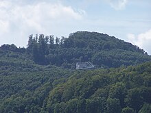
View northwest to Dietrichsberg with Wölferbütt (right) |
||
| height | 668.9 m above sea level NHN | |
| location | near Völkershausen ; Wartburgkreis , Thuringia ( Germany ) | |
| Mountains | Rhön ( Auersberger Kuppenrhön ) | |
| Dominance | 6.4 km → Baier | |
| Coordinates | 50 ° 46 '50 " N , 10 ° 1' 45" E | |
|
|
||
| Type | extinct volcano | |
| rock | basalt | |

The Dietrichsberg is 668.9 m above sea level. NHN high mountain in the Rhön . It is located near Völkershausen and Sünna in the Wartburg district in Thuringia .
geography
location
The Dietrichsberg rises in the Rhön Biosphere Reserve , within the Auersberger Kuppenrhön and in the southern part of the Wartburg district. It is located in the municipal areas of Vacha and Unterbreizbach ; Vacha includes most of the mountain with the summit. Mariengart lies southeast of the mountain , Wölferbütt to the southeast , Willmanns to the northeast, Völkershausen to the northeast and Rodenberg on the northern slope , all of which belong to Vacha. Southwest is Deicheroda , west-southwest Mosa , west Hüttenroda and northwest Sünna , all are among Unterbreizbach.
To the north of the mountain rises the Öchsenberg ( 627.2 m ) and south of the Sattelsberg ( Sattelberg ; 464.1 m ) lies the Arzberg ( 572.6 m ). To the east, the mountain is bounded approximately in a south-north direction by the valley of the Oechse , to the west by the valley of the Sünna , which rises on its southern slope and flows into the Oechse north of the Öchsenberg near Vacha.
In the small valley west of the transition area to the Öchsenberg is the open-air museum Keltendorf Sünna , and next door is the Celtic Hotel Goldene Aue .
Natural allocation
The Dietrichsberg belongs to the natural spatial main unit group Osthessisches Bergland (No. 35), in the main unit Vorder- und Kuppenrhön (353) and in the subunit Kuppenrhön (353.2) to the natural area Auersberger Kuppenrhön (353.24). The landscape falls to the east into the subunit Stadtlengsfelder Hügelland (359.0), which belongs to the main unit Salzunger Werrabergland (359) .
Protected areas
Parts of the Thuringian Rhön landscape protection area are located on the Dietrichsberg ( CDDA no. 20897; designated in 1989; 631.8923 km² in size). With the exception of the high altitudes and the summit, parts of the fauna-flora-habitat area Öchsenberg-Dietrichsberg-Sattelberg (FFH No. 5226-304; 9.62 ha ) and the Thuringian Rhön bird sanctuary (VSG No. 5326-401; 199.49 km²).
Mining
Heinrich Hagemeier, the former director of the Heiligenmühle potash union, which has been based in Niederoechsen since 1920 , began mining basalt on the Dietrichsberg in 1924 . He had a basalt works built near Masbach and a loading platform on the Wenigentaft-Mansbach-Oechsen railway line to process and transport the recovered material . The basalt works of the Thuringian hard stone works (from 1926: Heinrich Hagemeier GmbH Masbach (Rhön) ) became the largest employer in the region after the potash works in the Werra potash district . The quarry and the factory were connected by a cable car .
Hagemeier GmbH was expropriated and nationalized in the GDR in 1951 , and the Wenigentaft-Mansbach-Oechsen railway was shut down in 1952. The basalt works near Masbach was shut down at the end of 1961, then served as an LPG stable and road maintenance depot and was largely dismantled in 1999.
The quarry is now operated by Rhönbasalt Vacha GmbH .
See also
literature
- Geyer, Jahne, Storch: Geological sights of the Wartburg district and the independent city of Eisenach . In: District Office Wartburgkreis, Lower Nature Conservation Authority (Hrsg.): Nature conservation in the Wartburgkreis . Issue 8. Printing and publishing house Frisch, Eisenach and Bad Salzungen 1999, ISBN 3-9806811-1-4 .
Individual evidence
- ↑ a b c Map services of the Federal Agency for Nature Conservation ( information )
- ↑ Rhon lexicon: Dietrichsberg (with mention of volcanic origin), on rhoen.info
- ↑ Keltendorf Sünna , on keltendorf-suenna.de
- ↑ Werner Röll: Geographical land survey: The natural spatial units on sheet 126 Fulda. Federal Institute for Regional Studies, Bad Godesberg 1969. → Online map (PDF; 4.2 MB)
- ↑ Harald Rockstuhl : From the history of the Wenigentaft-Mansbach-Oechsen railway line, 1912–1952. Verlag Rockstuhl, Bad Langensalza 2000, ISBN 3-932554-00-0 , p. 39


