
Baier (Rhoen)
| Baier | ||
|---|---|---|
 View from the Gläserberg to the Baier and Unteralba |
||
| height | 713.9 m above sea level NHN | |
| location | Thuringia ( Germany ) | |
| Mountains | Rhön ( Kuppenrhön ) | |
| Coordinates | 50 ° 44 '50 " N , 10 ° 6' 16" E | |
|
||
| rock | basalt | |

The Baier is 713.9 m above sea level. NHN high mountain of volcanic origin on the northern edge of the Rhön in Thuringia , in the center of the Thuringian Rhön.
Geographical location
The Baier lies in the Thuringian Wartburg district in the northeast of the Auersberger Kuppenrhön . The Baier, recognizable from the north as a striking cone mountain, rises 2½ km northwest of Dermbach , through which the B 285 runs, or 6 km south-southwest of Stadtlengsfeld . It is located in the northern part of the Rhön Biosphere Reserve and is part of the Rhön volcano group formed in the tertiary period.
history
In the summit area on the north and east slopes of the mountain, two concentric ring walls made of basalt boulders can still be seen today , protecting the summit plateau. The inner ring is about 15 m below the summit, the outer about 30 m. On the north side a large sea of blocks offered natural protection and disrupted the formation of the wall. The northern and southern parts of the outer ring wall have two interruptions that are rated as entrances (secured by gates). The total protected area is about 3 hectares. The site is dated by ceramics as a settlement area of the pre-Roman Iron Age.
On the east side of the Baier is the Bayershof , a late medieval settlement approach, with alpine meadows and connecting paths to Gehaus , Weilar and Oberalba . It was owned by the Lords of Boyneburg zu Weilar ( Lordship of Lengsfeld ) and today serves as a (private) hiking hostel.
About 500 meters north of the farm in the hallway Thorny enclosure located in the woods, a group of a total of nine barrows are dated by archaeological finds in the Bronze Age and pre-Roman Iron Age. The three burial mounds on the hiking trail can also be easily recognized by laypeople, the group of six can only be recognized with difficulty in the area, as the hills are already very flat.
About 500 meters south of the homestead there is a single grave on the access road from Weilar. It was opened in 1836 and contained Bronze Age additions as jewelry for the dead. The investigations were carried out by the Dermbacher antiquarian Ferdinand Keller (pharmacist in his main profession). As early as the beginning of the 19th century, a trigonometric signal was set up on the summit of the striking mountain. The mountain could thus be sighted from surrounding observation points ( Inselsberg , Wartburg , Kreuzberg, etc.) and used for land surveying. The travel writer August Trinius reported about it in the fourth volume of his Thuringian hiking books in 1890 and mentioned that he had climbed a wooden slat frame with ladders. On the west side of the summit a lookout point was built with a view of the Hessian skittles . On May 17, 1914, the Karl-August-Turm was inaugurated on the Baier , which was destroyed in a fire in 1988.
hike
The main hiking trail T4 leads from Dermbach to Vacha along the eastern slope of the Baier. B. from the parking lot at the Emberghütte to commit this trail on the slightly lower Emberg near Oberalba . Direct ascents are also signposted by the responsible Rhönclub hiking club Dermbach with starting points in Unteralba , Weilar and Gehaus .

North
(walking distance - 2½ km)
East
(Weilar - 4 km)
South
(Dermbach - 4 km)
West
(Mariengart - 4 km)
Northeast
(Stadtlengsfeld - 4½ km)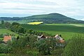
East
(Urnshausen - 5 km)
South (Emberghütte car park near Oberalba - 2½ km)


See also
literature
- Ineswalk, Thomas Grasselt, Roland Geyer: Wartburgkreis, south . Ed .: Thuringian State Office for Archaeological Monument Preservation (= Archaeological Hiking Guide Thuringia . No. 12 ). Beier & Beran, Weimar 2011, ISBN 978-3-941171-41-1 .
Web links
Individual evidence
- ↑ Map services of the Federal Agency for Nature Conservation ( information )
- ↑ walking, Grasselt, Geyer: Wartburgkreis, South . 2011, p. 120 f .
- ↑ walking, Grasselt, Geyer: Wartburgkreis, South . 2011, p. 118 .
- ↑ walking, Grasselt, Geyer: Wartburgkreis, South . 2011, p. 119 .
- ↑ Urmes table sheet Lengsfeld (with Dermbach)
- ^ Stefan Etzel: Hiking in the Rhön. Dumont Reiseverlag, Ostfildern 2007, ISBN 978-3-7701-8008-0 , p. 149.