
Emberg (mountain)
| Emberg | ||
|---|---|---|
 View from Oberalba to the Emberg |
||
| height | 541.9 m above sea level NHN | |
| location | near Dermbach , Wartburgkreis , Thuringia , Germany | |
| Mountains | Rhön (Kuppenrhön) | |
| Coordinates | 50 ° 43 '54 " N , 10 ° 5' 32" E | |
|
||
| particularities | Nature reserve, Landwehr | |

The Emberg is 541.9 m above sea level. NHN high, near Dermbach located foothills of the Thuringian mountain Baier in the Rhön , a German low mountain range near the border triangle of Bavaria , Hesse and Thuringia .
Geographical location
As the southwest foothills of the Baier ( 713.9 m ) - about 2 km southwest of its volcanic peak - the Emberg is located in the southern part of the Wartburg district in the Auersberger Kuppenrhön . It is located in the Rhön biosphere reserve around 750 m in the corridor of Oberalba , a north-western part of Dermbach.
history
Originally there was probably a small chapel in honor of Mary, from which his presumed former name Maria Ehrenberg was derived. In the course of time this probably changed via Ehrenberg to Emberg. An approximately two-kilometer-long Landwehr runs over the ridge of the Emberg as an early modern fortification, the trenches are still clearly visible just north of the state road at the Emberg car park.
The "Dermbacher Meterorit" was found in 1924 near the Emberg above Unteralba during forest work. The 1.5 kg find was initially mistaken for a lump of ore by the construction workers, and later it was taken to the Berlin Natural History Museum. Another piece of debris from the meteorite weighing 53 g was found years later near the impact site; it is now in the Dermbacher Heimatmuseum.

View from the Gläserberg to the Baier (North Rhön). Left the eastern slope of the Emberg
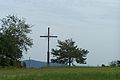
The summit cross at the Emberghütte

Information board at the Emberghütte about the meteorite find (1924)

View from the parking lot at the Emberghütte on the Emberg


Viewpoints
The Emberg offers several viewpoints :
- The popular picnic area at Emberghütte is situated on the main road and offers several gazebos and sitting areas with open views east to the island mountain ( 916.5 m ), Pless ( 645.4 m ), Dolmar ( 739.6 m ) and Feldatal to Dermbach.
- Another vantage point is located on the bike path 500 m to the west and offers a view of the upper Oechsetal to the west.
- A third vantage point is located near the summit (radio mast) and allows a view towards the southeast.
See also
Individual evidence
- ↑ a b Map services of the Federal Agency for Nature Conservation ( information )
- ↑ Official topographic maps of Thuringia 1: 10,000. Wartburgkreis, district of Gotha, district-free city of Eisenach . In: Thuringian Land Survey Office (Hrsg.): CD-ROM series Top10 . CD 2. Erfurt 1999.
- ^ Colloquium on the Dermbach meteorite find. Geneminde Dermbach, October 20, 2011, accessed March 9, 2018 .