Pleß (mountain)
| Pleas | ||
|---|---|---|
|
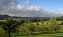
Stoffelskuppe (left) and Pleß (right) from the southwest |
||
| height | 645.4 m above sea level NHN | |
| location | near spreads ; District of Schmalkalden-Meiningen , Thuringia ( Germany ) | |
| Mountains | Salzunger Werrabergland is common: Vordere Rhön | |
| Dominance | 9.5 km → Baier | |
| Notch height | 275 m ↓ at Eckardts | |
| Coordinates | 50 ° 44 ′ 40 " N , 10 ° 14 ′ 30" E | |
|
|
||
| Type | extinct stratovolcano | |
| rock | basalt | |
| particularities | - Plesturm ( AT ) - TrÜbPl Bad Salzungen |
|

The Pleß is a 645.4 m above sea level. NHN high mountain of the Salzunger Werrabergland in the Thuringian district of Schmalkalden-Meiningen ( Germany ). It is of basaltic- volcanic origin.
geography
location
The Pleß rises - including its summit region - for the most part in the municipality of Breitungen to the northeast , and the municipality of Rosa , both in the district of Schmalkalden-Meiningen, extends onto its southern slope . At the Roßdorfer Tor ( 526.6 m ) to the south-west , the borders of both communities meet those of Roßdorf (Schmalkalden-Meiningen district) in the south-south-west and Dermbach ( Wartburg district ) in the west. The municipality of Bad Salzungen (Wartburgkreis) is located a little to the northwest of it .
Seen from the north-western part of the Thuringian Forest a little further to the north-east , the Pleß is to the left (or east- south- east) next to the mountains Baier ( 713.9 m ), Dietrichsberg ( Dietrich ; 667.4 m ) and Öchsenberg ( Öchsen ; 627.2 m ) . The south-western neighbor is the Stoffelskuppe ( 620.1 m ) 2.4 km away .
Natural allocation
The Pless is commonly known as the northeastern mountains of the Near Rhoen considered, however, was from the Federal Institute for Regional Studies natural area already for the northeast bordering Salzunger Werra Bergland expected. The Thuringian State Institute for Environment and Geology , in turn, assigns it to the Rhön. Genetically, it clearly comes from the volcanism of the Rhön, but is enclosed by the red sandstone of the Werrabergland.
According to the Bundesanstalt für Landeskunde, the Pless belongs to the natural spatial main unit group Osthessisches Bergland (No. 35) and in the main unit Salzunger Werrabergland (359) to the subunit Stadtlengsfelder Hügelland (359.0).
Protected areas
The fauna-flora-habitat area Pleß-Stoffelskuppe-Bernshäuser Kutte (FFH no. 5227-301; 15.7 km² ) and the Thuringian Rhön bird sanctuary (VSG no. ) Extend to parts of the northern and western slopes of the Pleß near the summit . 5326-401; 199.49 km²). The Thuringian Rhön landscape protection area extends to the transition area to the Stoffelskuppe at Roßdorfer Tor ( CDDA no. 20897; designated 1989; 631.8923 km²).
history
The original name of the Pleß 'was "Bleßberg". But since two Bleßbergs existed in the Duchy of Saxony-Meiningen , an "Oberland" Bleßberg near Eisfeld and this same "Unterland" one - which often led to confusion - the name was given to Pleßberg on the instructions of Duke Georg II at the end of the 19th century changed. A short time later, the term "mountain" was also dropped.
The Pleßhaus (north of the summit) and an observation tower were built on the Pleß as early as the 19th century. In the GDR , the mountain with the Bad Salzungen military training area , which extends to the northern and western slopes of the mountain, was declared a restricted area. The Pless was the location of a unit (FutK513) of the radio technical troops of the NVA for military air surveillance. The Pless House served as accommodation for the soldiers; later, when barracks were built on the Pless, it stood empty and fell into disrepair. The observation tower was also dismantled. Committed citizens stood up for the preservation of the Plesshaus. The new house was built on the Jägerstein. The restaurant there is called Seeblick .
After the political change, the Bundeswehr partially withdrew from Bleßberg in the 1990s. Since then, there has been another opportunity to hike the area - for example on the 175 km long Hochrhöner long-distance hiking trail that leads over the summit . In March 1996, the Breitungen community acquired the Pleßberg area and has had its own local mountain ever since.
Ples Tower
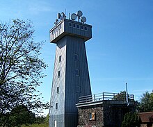
A lookout tower stood on the Pleß summit from 1921 to 1934; the second tower existed from 1936 to 1963. The third tower is the Ples Tower, inaugurated on October 2, 1999, which was made of sand-lime brick and has a facade made of titanium-zinc sheet metal. From its viewing platform at a height of 20 m you can look to the Thuringian Forest , the Rhön (with the Wasserkuppe ) and the Hessian skittles ; In addition, the view falls along the Werra and past the Wartburg to the Hohen Meißner .
gallery
View from the Thuringian Forest to the Pless
View from the direction of Meiningen past Landsberg Castle to the northwest to the Pleß on the horizon
See also
- List of mountains in the Rhön
- Plešivec (German Pleßberg ) in the Czech Ore Mountains
Web links
- 360 degree panorama from the Ples Tower. (Labeling of visual targets can be activated). In: panorama-photo.net. Retrieved May 6, 2020 .
Individual evidence
- ↑ a b c Map services of the Federal Agency for Nature Conservation ( information )
- ↑ Werner Röll: Geographical land survey: The natural spatial units on sheet 126 Fulda. Federal Institute for Regional Studies, Bad Godesberg 1969. → Online map (PDF; 4.2 MB)
- ↑ The Pless and its towers. In: Breitungen.de. Retrieved May 6, 2020 .
cards
- Topographic map: Western Thuringian Forest - Middle Werratal , M = 1: 50,000, No. 55, Thuringian State Office for Surveying and Geoinformation, ISBN 3-86140-265-3
- Hiking map: Thuringian Forest Nature Park - Trusetal, Bad Liebenstein, Bad Salzungen , M = 1: 30,000, Verlag grünes Herz , ISBN 3-929993-44-9


