Plešivec (Ore Mountains)
| Plešivec | ||
|---|---|---|
|
View to Plešivec from Abertamy |
||
| height | 1028.1 m above sea level HN | |
| location | Karlovy Vary Region , Czech Republic | |
| Mountains | Ore Mountains | |
| Dominance | 6.2 km → Božídarský Špičák | |
| Coordinates | 50 ° 21 '20 " N , 12 ° 50' 22" E | |
|
|
||
| rock | basalt | |
| Development | 1895 by the Association of Friends of Nature Abertham | |
|
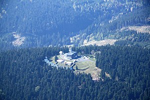
Aerial photo of the summit development (2009) |
||
The Plešivec ( German Pleßberg ) is a 1028 meter high mountain of the Ore Mountains in the Karlovy Vary region on the territory of the Czech Republic .
Location and surroundings
The Pleßberg is located southeast of Abertamy ( Abertham ) on the striking steep slope of the Ore Mountains down into the Egertal. To the west of the mountain lies the valley of the Bystřice ( Wistritz ).
Surname
There are several variants for the derivation of the German name. The Middle High German word merely means as much as naked, i.e. an unwooded mountain or a mere hilltop. The Czech name was derived from the German name.
history
On April 15, 1889, the "Association of Friends of Nature in Abertham" was founded on the initiative of Abertham Pastor Johann Endt. The construction of a control room on the Pleßberg was already a basic concern, although the building site was not yet owned by the association. But already on April 23, 1889, the association had this for the amount of 340 guilders. The construction of the control room and the 15-meter-high tower began in 1893 for the estimated construction cost of 5400 guilders, and was inaugurated on August 4, 1895. It was financed through donations and membership fees as well as loans. In the summer of 1895 the road to the summit was expanded. The inclusion in the course of the Kammweg in 1903 was of particular importance for the further tourist development of the Pleßberg. Five years later, the control room was extended, a garage followed in 1925 and the "Johann Endt-Saal" was added in 1927 a steam heater. Hot water and floor heating were installed later. In 1923 the tower was re-covered with zinc sheet. The observation lantern was destroyed in a strong storm in 1928 and was rebuilt soon afterwards. On September 12, 1930, the association decided to build an electricity connection for the control room, construction began on December 9, 1930 and the rooms were illuminated with electric light for the first time on December 21, 1930. In 1931 an open terrace was created for summer guests. A conversion of the route to the street was already laid out in 1911 and gradually implemented from 1914 onwards. Until at least 1939 there was no water pipe to the summit, so the landlord had to laboriously fetch the water from a well on the mountain slope. The opening of the railway lines Karlsbad – Johanngeorgenstadt (1899) and Dallwitz – Merkelsgrün (1902) led to a revitalization of tourism , at the train station in Bärringen a billboard was set up for 200 guilders. In 1909 the control room was connected to the telephone network. The association requested a post box as early as 1900, but did not receive it until 1912. In 1937 a further extension was completed and inaugurated on October 2nd of that year.
In 1928 a memorial stone was inaugurated on the occasion of Friedrich Ludwig Jahn's 150th birthday . This remembered him until shortly after the end of the Second World War. The stone still exists, but no longer reminds of Jahn.
In 2003, the tower's viewing platform was raised slightly to provide a better panoramic view.
In 2013 a completely new ski area was set up. The summit is now accessed by three chairlifts in winter.
Visible prominent points
- Auersberg
- Abertamy with the district of Hřebečná
- Blatenský vrch ( Plattenberg )
- Božídarský Špičák ( God's gift Spitzberg )
- Fichtelberg
- Klínovec ( Wedge Mountain )
- Mariánská
- Ostrov nad Ohří
- Karlovy Vary
Routes to the summit
- From Boží Dar ( Gottesgab ) on the Anton-Günther -Weg, first marked in red to behind the Božídarský Špičák ( Gottesgaber Spitzberg ), then following the yellow marking to the summit (approx. 12 km).
- From the station Pernink ( Bärringen ) at the Karlovy Vary-Johanngeorgenstadt railway on the road in the valley of Bystřice down to Pstruží ( Salmthal ). In the village turn left and through the romantic Modesgrund up to Abertamy. Here the green marked Anton-Günther-Weg up to the hilltop (approx. 10 km).
- A road up to the top branches off from road No. 219 Abertamy – Jachymov not far from Abertamy.
literature
- Josef Rödig: The Pleßberg, a crown guardian of the Erzgebirge love of home . In: Nordwestböhmischer Gebirgsvereins-Verband (Hrsg.): Erzgebirgs-Zeitung. Monthly for folklore and local history, hiking care and tourism . 7th-8th Issue of the 60th volume, July – August. Teplitz-Schönau 1929, p. 66-70, 77-80 ( digitized version ).
- Reinhart Heppner , Jörg Brückner , Helmut Schmidt: Saxon-Bohemian panoramic mountains of the western Ore Mountains in words and pictures with tourist information. Horb am Neckar 2000, pp. 24-26.
Web links
Individual evidence
- ↑ Josef Rödig: The Pleßberg, a crown guardian of the Erzgebirge love of home . In: Erzgebirgs-Zeitung . S. 66-70, 77-80 ( digitized version ).
- ↑ Josef Rödig: The Pleßberg, a crown guardian of the Erzgebirge love of home . In: Erzgebirgs-Zeitung . S. 80 ( digitized version ).


