Oberellen
|
Oberellen
community Gerstungen
Coordinates: 50 ° 56 ′ 58 ″ N , 10 ° 11 ′ 8 ″ E
|
|
|---|---|
| Height : | 242 (235-250) m |
| Area : | 16.8 km² |
| Residents : | 870 (Jun 30, 2007) |
| Population density : | 52 inhabitants / km² |
| Incorporation : | March 16, 2004 |
| Postal code : | 99834 |
| Area code : | 036925 |
|
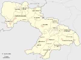
Oberellen in the center of the municipality
|
|
Oberellen is part of the municipality of Gerstungen in the Wartburg district in Thuringia ( Germany ).
geography
Oberellen is about 11 kilometers west of Eisenach . The Elte flows north of the village . The wooded Lehne mountain with the side peaks Ehmesberg , Ellerberg , Mordberg , Ritzberg and Wolfsberg is a highly structured elevation on the field boundary to Marksuhl and forms the watershed between the Eltetal and the Suhl valley . The geographical height of the place Oberellen is 235 m above sea level. NN .
geology
The south-west of the district is characterized by the sequence of layers of the red sandstone . In the north-west, the Zechstein rock sequence leads to a rise to the heights of the north-west Thuringian Forest formed by Rotliegend conglomerates . In the red sandstone area, numerous trough valleys are formed and the landscape is therefore strongly structured.
Land use
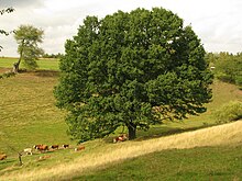
The high altitudes are often wooded and are used for forestry purposes. Traditionally, the proportion of grassland is relatively high. Old hat trees in the hallway partly testify to traditional pasture management.
history
The village of Oberellen was built at a ford on the trade route known as Kurz Hessen in the Middle Ages - a side branch of the Hohen Strasse - also Via Regia in the Eisenach - Oberellen - Herda - Berka / Werra section .
The earliest documented mention of the place dates from the year 1014. Fulda Monastery is considered the landlord and owner of the place . King Heinrich IV stayed several times with his army in the Werra area in 1075 to pacify the rebellious Thuringians and Saxons. During one of these punitive expeditions, his army rested before the decisive battle near Langensalza (Homburg Monastery) near the village of Elnde.
In the 12th century the village came into the possession of the Knights of Goldbach , whose ancestral seat was west of Gotha in the village of the same name on the Nesse . The Goldbach knights were ministerials to the Thuringian landgraves . Ownership of Elnde was ceded to Reinhardsbrunn Monastery in 1121 . A chapel that has been in the village since ancient times was designated by the abbot to be the provost's office - today's Oberellen village church - and the existing goods were merged to form a farm yard for the monastery.
Later Oberellen fell together with Clausberg , Frommeshof , Hütschhof and Dachsberg as an exclave to the County of Henneberg , so that these places also belonged to the Franconian Empire , which was founded in 1500 . The existence as an exclave connected to the south continued until 1922 with the affiliation to Sachsen-Meiningen . Until 1868, the places mentioned belonged to the Salzungen office . Hundreds of, often meter high, boundary stones around the town still bear witness to this special role.
With the secularization of the Thuringian monasteries, the property came in 1543 to the imperial officer Conrad von Hanstein († 1553) through whom the Eichsfeld noble family von Hanstein took over the village as court and liege lords. Two representative castles were built in the village, one of which is Oberellen Castle . The church was completely modernized in the 16th century. The search for copper ore in the 16th century led to a sharp increase in mining with its side effects: overexploitation of the forest to cover the need for charcoal and pit wood . Extensive pingen fields and tunnels can still be found today from the Rangenhof to the Clausberg. Away from the main town, several individual farms were built in the side valleys: Frommeshof, Rangenhof, Hütschhof , Dachsberg ( desert ) and the Clausberg - probably a high medieval hermitage (rest stop) on the Rennsteig.
The place recovered quickly from the consequences of the Thirty Years' War and the numerous splendid half-timbered houses that still exist today prove the prosperity of the population in the following years. On March 16, 2004, Oberellen became part of the unified community of Gerstungen.
Population development
| year | Residents |
|---|---|
| December 31, 2004 | 887 |
| 06/01/2005 | 888 |
| December 31, 2005 | 861 |
| December 31, 2006 | 858 |
| 06/30/2007 | 870 |
politics
Frank Bönicke (CDU) became the first local mayor after the unified community was formed in 2004. He was replaced by Caterina Körner, who stood for SPD / Free Voters, in the local elections in June 2009.
Culture and sights
The townscape is still largely shaped by the traditional half-timbered architecture. Numerous buildings in the village center are listed.
The village church Oberellen is distinguished by a Romanesque tympanum from the time of their belonging to the monastery Reinhardsbrunn and Renaissance - epitaphs of the noble family Hanstein . The portal of Oberellen Castle , which is decorated with splendid coats of arms and built between 1594 and 1604, also refers to its former owners, the von Hanstein family. In the castle there is now a pilgrims' hostel next to the castle hermitage. The place is part of a Thuringian section of the Way of St. James . In addition to the Evangelical Church in Central Germany , an Evangelical Free Church ( Baptist ) congregation is represented in the town.
Other sights are the Frommeshof, a splendid half-timbered farmstead north of the village, and the Clausberg estate with a castle-like mansion on the Rennsteig . North of the Clausberg leads the mining educational trail "With hammer and mallet". On the Rennsteig , at the easternmost point of the district, you come across the Vachaer Stein , a path obelisk from the 19th century.
The Sallmannshäuser Rennsteig , a branch of the Rennsteig, runs south of Oberellen along the old trade route " Kurz Hessen " . The hiking trail marked with an "S" connects the Thuringian Forest with the Werra Valley.
For several decades the village community has had a traditional festival every year - the fair .
Economy and Infrastructure
The economic development of Oberellen was geared towards agriculture during the GDR era. On the eastern and western outskirts of the town, two building complexes were designed as a large-scale agricultural operation and farmed until the reunification. Part of the building is currently unused and left to decay.
Today the economy of the place is determined by small traders.
traffic
Road traffic Junction 36 ( Gerstungen ) of the A 4 can be reached via the L1020 - 16 kilometers. Junction 37 ( Wommen ) of the A 4 can be reached via Sallmannshausen and Neustädt after 16 kilometers.
Rail transport Due to the division of Germany , the Förtha – Gerstungen railway line with the Dietrichsberg stop was built in 1962 to the south of the town . After the Werra Valley Railway was put back into operation on the original route via Herleshausen , the railway line was dismantled in 1993.
Today the nearest train station is in Förtha on the Werra Railway .
Bus traffic The following bus routes run by the Verkehrsgesellschaft Wartburgkreis mbH operate to Oberellen:
| line | Driving distance |
|---|---|
| L-50 | Eisenach - Oberellen - Eckardtshausen |
| L-50a | Eisenach - Wilhelmsthal - Wolfsburg-Unkeroda - Oberellen - Gerstungen |
| L-51 | Eisenach - Hörschel - Neuenhof - Lauchröden - Unterellen - Oberellen |
| L-52 | Eisenach - Marksuhl - Berka (Werra) - Dankmarshausen - Großensee |
| L-53 | Eisenach - Lauchröden - Sallmannshausen - Gerstungen-Untersuhl |
| L-93 | Eisenach - Stedtfeldt - Neuenhof - Lauchröden - Unterellen - Oberellen |
Personalities
- Alfred Hoehn (1887–1945), pianist, born in Oberellen
Individual evidence
- ↑ Official topographic maps of Thuringia 1: 10,000. Wartburgkreis, district of Gotha, district-free city of Eisenach . In: Thuringian Land Survey Office (Hrsg.): CD-ROM series Top10 . CD 2. Erfurt 1999.
- ^ Hans-Dieter von Hanstein: Hanstein Castle: on the 700-year history of a border fortress in Eichsfeld , Mecke Druck und Verlag, 2008, p. 30, ISBN 3936617481 ; (Digital scan)
- ^ StBA: Changes in the municipalities in Germany, see 2004
- ↑ a b c d e Oberellen.de> Statistics
- ↑ Historical mining near Stedtfeld. (PDF; 2.6 MB) In: Eisenach.de - Internet portal of the Wartburg city. Retrieved May 9, 2009 .
- ↑ Timetable of the Verkehrsgesellschaft Wartburgkreis mbH


