Backrest (upper part)
| rest | ||
|---|---|---|
|
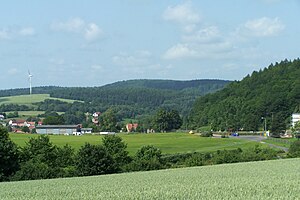
Lehnberg (in the background) and Ritzberg (with wind turbine) |
||
| height | 392.2 m above sea level NN | |
| location | Thuringia ( Germany ) | |
| Mountains | Thuringian Forest | |
| Coordinates | 50 ° 55 '52 " N , 10 ° 11' 52" E | |
|
|
||
| rock | Red sandstone | |
| particularities | "Pflasterkaute" (basalt chimney) | |
The mountain Lehne is a strongly structured, ( 392.2 m above sea level ) high mountain in the Wartburg district in Thuringia , the north and west side belong to the area of the municipality Gerstungen .
The Lehne mountain is about 5 km south of the Rennsteig and marks the watershed between the Suhl Valley and the Elte Valley .
The following wooded knolls and spur-like slopes (position and height) also belong to the mountain:
- Mordberg ( ⊙ 353.7 m above sea level ), Marksuhl district
- Ritzberg ( ⊙ 336 m above sea level ), Marksuhl and Förtha district
- Ellerberg ( ⊙ 308.4 m above sea level ), Marksuhl district
- Wolfsberg ( ⊙ 358.1 m above sea level ), Wünschensuhl district
- Hohe Balz ( ⊙ 351.3 m above sea level ), Oberellen district
- Ehmesberg ( ⊙ 321.4 m above sea level ), Oberellen district
On the eastern flank of the mountain, the federal highway 84 leads from Eisenach via Förtha to Marksuhl as the successor to the medieval “Frankfurter Straße”. The Pflasterkaute is a geological natural monument on the road - a volcanic vent filled with basalt and a witness of the former Rhön volcanism in the Tertiary. The Lehnberg is partially forested again, the afforestation has been taking place since the 19th century.
Individual evidence
- ↑ Official topographic maps of Thuringia 1: 10,000. Wartburgkreis, district of Gotha, district-free city of Eisenach . In: Thuringian Land Survey Office (Hrsg.): CD-ROM series Top10 . CD 2. Erfurt 1999.

