
Herleshausen
| coat of arms | Germany map | |
|---|---|---|

|
Coordinates: 51 ° 0 ′ N , 10 ° 10 ′ E |
|
| Basic data | ||
| State : | Hesse | |
| Administrative region : | kassel | |
| County : | Werra-Meißner district | |
| Height : | 263 m above sea level NHN | |
| Area : | 59.52 km 2 | |
| Residents: | 2790 (Dec. 31, 2019) | |
| Population density : | 47 inhabitants per km 2 | |
| Postal code : | 37293 | |
| Area code : | 05654 | |
| License plate : | ESW, WIZ | |
| Community key : | 06 6 36 005 | |
| LOCODE : | DE HHA | |
| Community structure: | 11 districts | |
| Address of the municipal administration: |
Bahnhofstrasse 15 37293 Herleshausen |
|
| Website : | ||
| Mayor : | Lars Böckmann (non-party) | |
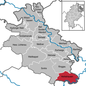
| Location of the municipality of Herleshausen in the Werra-Meißner district | ||
  |
||

Herleshausen is a municipality in the Werra-Meißner district in Hesse ( Germany ).
geography
Geographical location
Herleshausen is located in the northeast of Hesse, immediately north of a section of the state border with Thuringia and in the extreme south of the Frau-Holle-Land Geo-Nature Park between the Ringgau in the northwest and the Thuringian Forest with the Thuringian Forest Nature Park in the southeast. The municipality is bounded to the south by the Werra river .
Herleshausen borders on the area of the Thuringian city Eisenach , whose core city is about ten kilometers east-southeast. It is around 22 km to the district town of Eschwege in the north-northwest direction and around 60 km (as the crow flies ) to Kassel , Göttingen and Erfurt (closest major cities ).
Neighboring communities
Herleshausen borders in the north on the municipality of Ringgau (Werra-Meißner-Kreis) and the town of Treffurt ( Wartburgkreis in Thuringia, district Ifta ), in the east on the district of Creuzburg of the city of Amt Creuzburg and the district of Pferdsdorf of the municipality of Krauthausen (both in the Wartburg district) , in the southeast to the districts of Wartha and Göringen of the city of Eisenach , in the south to the municipality of Gerstungen (Wartburgkreis, districts Lauchröden and Sallmannshausen ) and to the west to the city of Sontra (Werra-Meißner district).
structure
The community consists of the eleven districts of Altefeld , Archfeld , Breitzbach , Frauenborn , Herleshausen, Holzhausen , Markershausen , Nesselröden , Unhausen , Willershausen and Wommen . In the district of Herleshausen about one kilometer northeast of the town is located on the high plateau of Kiel Forst of Siegelshof .
history

Herleshausen was first mentioned as Herleicheshuson in a deed of donation in 1019 , later mentions are Herlecheshusin (1229), Herleshusen (1268) and Herlshusin (1423). In the deed of donation, the place was transferred to the Kaufungen Monastery , under whose administration the village remained until the secularization of the Hessian monasteries in 1527. Then it came to the Landgrave of Hesse-Kassel , who see it as a fief to the family Recke Roth and post them to the family Wersebe gave.
Rudolf von Reckeroth built a small castle; he was followed by the von Wersebe family. At the end of the 17th century, Landgrave Philipp von Hessen-Philippsthal took over the castle and estate and later received both as a gift from his brother, Landgrave Karl.
During the November pogrom of November 9th to 10th, 1938, the local synagogue , built in 1846 and completely renovated in 1928, was completely destroyed. The ruin was removed in 1939. Since 2008 a memorial plaque commemorates the former house of God.
On March 19, 1945, a passenger train on the Eisenach-Bebra railway line was attacked by Allied low-flying aircraft near Herleshausen . There were at least nine, according to eyewitness reports up to 35 dead and several injured.
Herleshausen became known to a wider public after the Second World War , when the Wartha / Herleshausen border crossing was established here, one of the few crossings into the GDR that can be passed by car . On January 16, 1956, the last rail transport with 602 late returnees from Soviet captivity arrived at Herleshausen station . Between 1962 and 1992 Herleshausen was bypassed on the Förtha – Gerstungen railway line .
Frauenborn has belonged to Herleshausen since April 1st, 1969. On December 1, 1970, as part of the regional reform in Hesse, the municipalities of Altefeld, Archfeld, Breitzbach, Herleshausen (with Frauenborn), Holzhausen, Markershausen, Nesselröden, Unhausen, Willershausen and Wommen voluntarily merged to form the larger municipality of Herleshausen with 3,696 inhabitants at that time. 40 years later the population has dropped to less than 3,000.
On November 4, 2013, nineteen stumbling blocks were laid in the community to commemorate the Jewish residents who were murdered during the National Socialist era .

politics
mayor
In the mayoral election on June 17, 2012, Burkhard Scheld (non-party for the SPD) was elected as the successor to long-serving mayor Helmut Schmidt (SPD) with 54.3% of the vote. In the election on May 27, 2018, Scheld was defeated by his challenger Lars Böckmann (CDU / Wahlgemeinschaft Südringgau), who received 59.2% of the valid votes.
Community representation
The local elections on March 6, 2016 produced the following results, compared to previous local elections:
| Parties and constituencies |
% 2016 |
Seats 2016 |
% 2011 |
Seats 2011 |
% 2006 |
Seats 2006 |
% 2001 |
Seats 2001 |
||
|---|---|---|---|---|---|---|---|---|---|---|
| SPD | Social Democratic Party of Germany | 43.8 | 7th | 40.7 | 6th | 49.1 | 9 | 53.3 | 10 | |
| CDU | Christian Democratic Union of Germany | 30.2 | 4th | 34.7 | 5 | 32.4 | 6th | 30.7 | 6th | |
| WSRG | Voting community Südringgau | 26.0 | 4th | 24.6 | 4th | 18.5 | 4th | 16.0 | 3 | |
| total | 100.0 | 15th | 100.0 | 15th | 100.0 | 19th | 100.0 | 19th | ||
| Voter turnout in% | 59.5 | 60.0 | 65.0 | 66.9 | ||||||
Intermunicipal cooperation
Together with the neighboring communities of Sontra ( Werra-Meißner district ) and Nentershausen ( Hersfeld-Rotenburg district ), the association for inter-municipal cooperation was founded on October 14, 2006 . From this, a close cooperation of these three municipalities develops with partly already superordinate handling of common tasks in the fields of economy, culture, education, leisure activities, tourism and agriculture.
Community partnerships
Herleshausen maintains partnership relationships with the French community of Cléder in Brittany and the immediately adjacent Thuringian town of Lauchröden, a district of Gerstungen.
coat of arms
The coat of arms shows a silver crenellated wall with a golden closed gate, which ends on both sides in pointed silver round towers, which is surmounted by a tower with a double Welsh hood (castle church).
The battlements symbolize the former defensive wall around the Herleshausen churchyard, which is dominated by the choir tower of the fortified church originally built around 1300, today's parish church. The colors red and white are the Hessian state colors. The coat of arms was approved by the Hessian Ministry of the Interior in 1984.
Culture and sights
Buildings
Augustenau Castle
(Location: 51 ° 0 ′ 20 ″ N, 10 ° 9 ′ 53 ″ E )

After the introduction of the Reformation and the secularization of the monasteries in Hesse, Landgrave Philipp the Magnanimous gave the Herleshausen estate to his troop leader Georg von Reckrodt , who built the “Steinstock” castle there in 1539. After Reckrodt's death in 1558 he was succeeded as feudal men by the Lords of Wersabe , who enlarged the complex by adding two wings. When the Wersabes became extinct in the male line in 1678, the Herleshausen palace and estate fell back to Landgrave Karl von Hessen-Kassel as a settled fiefdom , who transferred it to his brother Philipp, initially as a fiefdom and later as property. Since then, the castle and estate have been owned by the Landgraves of Hesse-Philippsthal . In 1821 the castle was named "Augustenau" after Landgrave Carl's wife Auguste von Hohenlohe-Ingelfingen, who died early. After the main Hessen-Philippsthal line died out, the property fell to the Hessen-Philippsthal-Barchfeld branch in 1925 , to which it still belongs to this day.
Herleshausen war cemetery
In 1593, mostly Soviet prisoners of war were buried in the Herleshausen war cemetery, most of whom died in the former Stalag IX B on the road to Frauenborn .
Gut Hohenhaus

The Hohenhaus estate near the Holzhausen district belonged to the von Buttlar family for centuries . In 1856 Ferdinand von Schutzbar called Milchling acquired the estate. He was also head of the Kaufungen chivalrous monastery. His son, the Royal Chamberlain and Rittmeister Rudolf von Schutzbar, had the previously simple manor house converted into a castle-like cottage in the English country house style by the architect Bodo Ebhardt in 1901 . The palace park was laid out at the turn of the century in Victorian style by the Berlin garden architect Martin Bertrams. In 1934 ownership passed to a Hamburg publishing family. The castle was repaired around 1950 and converted into a hotel in 1982 by the Frankfurt architect Jochen Jourdan.
Altefeld main stud
In 1913, the chief stableman of the Prussian stud administration, Burchard von Oettingen , had a main stud built in Altefeld . Today the Altefeld main stud is privately owned.
Sports
In 1975 a swimming pool was built on the northern edge of the town. The largest sports club in the municipality is TSV Herleshausen, founded in 1869, which is active in the fields of soccer, gymnastics, judo, bowling, athletics, swimming, table tennis, gymnastics and volleyball.
traffic

Herleshausen has a stop on the Halle – Bebra railway line . The Eisenach railway station is the nearest connection to the IC - and ICE network of the Deutsche Bahn .
By the municipality that leads A 4 to the terminal points Herleshausen and Wommen (which can only be driven in one direction to and from the east). The Herleshausen service area was demolished in 2005 as part of the 6-lane expansion. The Burgberg car park was built in its place in 2010, and the Werratal car park in the direction of Dresden has been in operation since 2015 . In the future, the A 44 will branch off from the A 4 at Wommen .
The federal highway 400 opens at the Wommen motorway junction .
Personalities
- Sebastian Weygandt (1760–1836), painter
- Wilhelm Busch (1892–1968), politician (NSDAP)
- Walter Otto (1907–1998), judge
- Dirk Wilutzky (* 1965), film producer and director, Oscar winner 2015 in the category "Best Documentary"
Web links
- Internet presence of the municipality of Herleshausen
- "Herleshausen, Werra-Meißner district". Historical local dictionary for Hessen. In: Landesgeschichtliches Informationssystem Hessen (LAGIS).
- Literature about Herleshausen in the Hessian Bibliography
- Search for Herleshausen in the archive portal D of the German Digital Library
Individual evidence
- ↑ Hessian State Statistical Office: Population status on December 31, 2019 (districts and urban districts as well as municipalities, population figures based on the 2011 census) ( help ).
- ↑ "Herleshausen, Werra-Meißner district". Historical local lexicon for Hesse (as of February 26, 2014). In: Landesgeschichtliches Informationssystem Hessen (LAGIS). Hessian State Office for Historical Cultural Studies (HLGL), accessed on July 11, 2014 .
- ↑ Herleshausen Synagogue on alemannia-judaica.de, accessed on November 6, 2013
- ↑ Hälbig, Eberhard and Rainer Lämmerhirt : Air war in the Eisenach-Gotha-Hainich-Werratal-Thuringian Forest area 1943-1945 . Publishing house Rockstuhl, Bad Langensalza. 2nd edition 2013. ISBN 978-3-86777-348-5 , page 180f.
- ^ Federal Statistical Office (ed.): Historical municipality directory for the Federal Republic of Germany. Name, border and key number changes in municipalities, counties and administrative districts from May 27, 1970 to December 31, 1982 . W. Kohlhammer, Stuttgart / Mainz 1983, ISBN 3-17-003263-1 , p. 388 .
- ↑ Merger of the communities of Altefeld, Archfeld, Breitzbach, Herleshausen, Holzhausen, Markershausen, Nesselröden, Unhausen, Willershausen and Wommen in the district of Eschwege to form the new community "Herleshausen" on December 1, 1970 . In: The Hessian Minister of the Interior (Ed.): State Gazette for the State of Hesse. 1970 No. 51 , p. 2381 , item 2384 ( online at the information system of the Hessian state parliament [PDF; 7.5 MB ]).
- ↑ Website of the Herleshausen community , accessed on January 20, 2011
- ↑ In Herleshausen the first stumbling blocks of the Jewish victims are commemorated , Thüringische Landeszeitung from November 5, 2013, accessed on November 6, 2013.
- ↑ Mayoral election in Herleshausen at the Hessian State Statistical Office , accessed on June 18, 2012
- ↑ Hessenschau: Mayor election Herleshausen , accessed on May 28, 2018
- ^ Result of the municipal election on March 6, 2016. Hessian State Statistical Office, accessed in April 2016 .
- ^ Hessian State Statistical Office: Result of the municipal elections on March 27, 2011
- ^ Hessian State Statistical Office: Result of the municipal elections on March 26, 2006
- ↑ Text of the community on the camp ( Memento from September 24, 2015 in the Internet Archive ) (PDF; 2.9 MB)
- ^ The Altefeld main stud ( Memento from October 12, 2008 in the Internet Archive )
- ↑ Herleshausen indoor swimming pool , accessed on October 22, 2016
- ↑ TSV Herleshausen , accessed on October 22, 2016

Bad Sooden-Allendorf | Berkatal | Eschwege | Großalmerode | Herleshausen | Hessisch Lichtenau | Meinhard | Meissner | Neu-Eichenberg | Ringgau | Sontra | Waldkappel | Wanfried | Wehretal | Weißenborn | Witzenhausen
Community-free area in the Werra-Meißner
district of the Kaufunger Wald estate