
Nentershausen (Hesse)
| coat of arms | Germany map | |
|---|---|---|
.png)
|
Coordinates: 51 ° 1 ' N , 9 ° 56' E |
|
| Basic data | ||
| State : | Hesse | |
| Administrative region : | kassel | |
| County : | Hersfeld-Rotenburg | |
| Height : | 299 m above sea level NHN | |
| Area : | 57.06 km 2 | |
| Residents: | 2566 (Dec. 31, 2019) | |
| Population density : | 45 inhabitants per km 2 | |
| Postcodes : | 36214, 36208 (Bellers) , 36219 (Menglers) |
|
| Primaries : | 06627, 05653 (Mönchhosbach) | |
| License plate : | HEF, ROF | |
| Community key : | 06 6 32 013 | |
| Community structure: | 6 districts | |
| Address of the municipal administration: |
Burgstrasse 2 36214 Nentershausen |
|
| Website : | ||
| Mayor : | Ralf Hilmes ( SPD ) | |
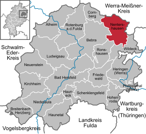
| Location of the community of Nentershausen in the district of Hersfeld-Rotenburg | ||
  |
||

Nentershausen is a municipality in the district of Hersfeld-Rotenburg in the north-east of Hesse in Germany .
geography
Geographical location

The community is located in the district of Hersfeld-Rotenburg in the eastern Hessian mountainous region. There it is located in the center of the Richelsdorf Mountains , between the Fulda in the west and the Werra in the east. The municipality is located in the catchment area of hazel , which in Sontra in the river Sontra flows.
The nearest larger cities are Bad Hersfeld (about 25 km southwest), Eisenach (about 30 km east) and Eschwege (about 25 km north).
Neighboring communities
Nentershausen borders in the north and east on the town of Sontra (in the Werra-Meißner district ), in the southeast on the community Wildeck , in the south on the community Ronshausen and in the west on the town of Bebra and the community Cornberg (all in the district of Hersfeld-Rotenburg ).
Community structure
In addition to Nentershausen, the community consists of the districts Bauhaus , Dens , Mönchhosbach , Süß and Weißenhasel .
history
The first written mention of one of the districts comes from the interest register of the monastery Helmershausen (today belongs to the unitary community Rhönblick ). Here, in 1120, Hasels was mentioned as Hasolo in Thuringia . Tense followed in 1195 and Susse in 1267, which Hermann von Trott had received as a Lauterberg fief. The other places followed in the course of the 14th century.
By 1300, built Ludwig I. von Baumbach , the Tannenberg castle , the feudal castle of Hersfeld Abbey was. The place Nentershausen was mentioned for the first time in 1323 in a document of the Blankenheim monastery , a daughter monastery in Herfeld. As early as 1365, the Lords of Baumbach in Nentershausen had numerous estates in fiefdom from the Hersfeld Monastery . They had high and low jurisdiction in Nentershausen and the surrounding villages . In 1578 the Baumbach had to hand over the high jurisdiction to the Landgrave of Hesse , and since then the judicial district has been administratively attached to the Sontra office. The lords of Baumbach retained the lower jurisdiction until 1806.
Around 1771, the office or court of Nentershausen included: Nentershausen, Dens, Blankenbach, Machtlos, Weißenhasel, Suss, Bosserode, Raßdorf, the three courtyards of Tannenberg, Bellers and Bauhaus. During the French occupation and the time of the Kingdom of Westphalia from 1807 to 1813, Nentershausen was the capital of the canton of Nentershausen . From 1821 the place belonged to the district of Rotenburg (Fulda) , which has been part of the district of Hersfeld-Rotenburg since 1972 .
Until 2011 the place was a state-recognized health resort .
Incorporations
In the course of the regional reform, the previously independent municipalities of Bauhaus, Dens, Mönchhosbach, Nentershausen, Süß and Weißenhasel merged on December 31, 1971 to form the new large municipality of Nentershausen.
politics
Community representation
The local elections on March 6, 2016 produced the following results, compared to previous local elections:
| Parties and constituencies |
% 2016 |
Seats 2016 |
% 2011 |
Seats 2011 |
% 2006 |
Seats 2006 |
% 2001 |
Seats 2001 |
||
|---|---|---|---|---|---|---|---|---|---|---|
| SPD | Social Democratic Party of Germany | 66.1 | 10 | 63.3 | 9 | 63.5 | 15th | 63.6 | 15th | |
| CDU | Christian Democratic Union of Germany | 33.9 | 5 | 36.7 | 6th | 36.5 | 8th | 36.4 | 8th | |
| total | 100.0 | 15th | 100.0 | 15th | 100.0 | 23 | 100.0 | 23 | ||
| Voter turnout in% | 63.3 | 63.6 | 61.9 | 67.1 | ||||||
mayor
The former mayor Lothar Schmidt (SPD) was elected into his fourth term of office on September 10, 2000 with 90.6% of the votes. Lothar Schmidt was first elected on December 17, 1982, for the term of office beginning January 1, 1983. On September 3, 2006 Ralf Hilmes (SPD) was elected with a share of the vote of 71.7% and replaced Lothar Schmidt as mayor on January 1, 2007.
coat of arms
Blazon : The coat of arms shows under a silver shield head in shields divided by green and silver to form six pinnacles, above three green fir trees in a pine cut, below a green three-hill covered with gold mallets and iron in the shield base.
The coat of arms was awarded to the community on November 4, 1981 by the Hessian Minister of the Interior.
Description: The fir trees in the upper part of the sign indicate the abundance of forests in the community. The six battlements symbolize the six districts and Tannenberg Castle. Schlegel and Eisen point to the mining past. Copper slate was mined in Nentershausen until the middle of the 20th century .
Intermunicipal cooperation
Together with the neighboring communities of Herleshausen and the city of Sontra (both Werra-Meißner district ), the special purpose association for inter-municipal cooperation was founded on October 14, 2006 . From this, a close cooperation of these three municipalities develops with partly already superordinate handling of common tasks in the areas of economy, culture (education), leisure activities (tourism) and agriculture.
Community partnerships
- Ligueil ( Indre-et-Loire department in France , since 1990)
- Brotterode-Trusetal ( Thuringia , since 1990)
- Steglitz-Zehlendorf district of Berlin (originally Steglitz district , since 1966)
A sponsorship existed for the 4th Company of the 5th Panzer Reconnaissance Battalion in Sontra . This sponsorship was ended on December 31, 2007 when the Armored Reconnaissance Battalion 5 was dissolved.
Culture and sights

Museums
- Local history and mining museum (with a focus on copper slate and heavy spar mining) in the former district court
Buildings
- Tannenberg Castle (built in the 13th century in Gothic style, owned by the von Baumbach family since 1360 )
- Evangelical Church in Nentershausen (rebuilt from 1696 to 1706 in the Baroque style)
- Half-timbered town hall in Nentershausen
Jewish history
- Synagogue : The half-timbered building built around 1810 was devastated in 1938 and demolished in 1987 in order to be rebuilt in Hessenpark near Neu-Anspach . Parts of the old Torah shrine are now at the Holocaust Museum of Washington . After the new construction of the mikveh , the ritual bath, the construction and interior fittings including the galleries could be completed by 1996.
- Jewish cemetery: The cemetery was established around the middle of the 19th century and was occupied until the 1930s.
Natural monuments
In Nentershausen there is an approximately 600 year old protected village or court linden tree .
Regular events
- Denser lake festival
- Castle festival at Tannenberg Castle
Personalities
sons and daughters of the town
- Ernst Wilhelm von Baumbach (1791–1860), Württemberg Lieutenant General and Governor of Stuttgart
- Henriette Dorothea (Dortchen) Wild (married Wilhelm Grimm in 1825 )
- Jost von Trott zu Solz (1944–2009), German lawyer
Personalities who have worked in the church
- Adolph Knigge (1752–1796), writer and educator. In 1773 he married Henriette von Baumbach, whose estates and Tannenberg Castle are located here. He also lived here for a while.
- Philippine von Reden (1775–1841), writer and translator, daughter of Adolph Knigge
- Franz Brandl (1926-2008), miner. Theodor Heuss awarded him the first Federal Cross of Merit of the Federal Republic of Germany in 1951 .
literature
- Ludwig Büff: On the history of Nentershausen. Blücher Verlag, Merzhausen 2004, ISBN 3-934249-06-X
- Karl-Heinz Berndt: The Judenpfad: A contribution to the history of the Jews in Nentershausen. Books on Demand, October 9, 2007, ISBN 978-3-8334-8239-7
- The parish council of the parish Nentershausen: Nentershausen pictures from past days . Geiger-Verlag, Horb am Neckar 1992, ISBN 3-89264-733-X
- The parish council of the parish Nentershausen: Sweet - the village and its people . Hoehl-Druck, Bad Hersfeld 2005
Individual evidence
- ↑ Hessian State Statistical Office: Population status on December 31, 2019 (districts and urban districts as well as municipalities, population figures based on the 2011 census) ( help ).
- ↑ "Nentershausen, Hersfeld-Rotenburg district". Historical local dictionary for Hessen. (As of December 11, 2015). In: Landesgeschichtliches Informationssystem Hessen (LAGIS).
- ^ Homepage of Nentershausen
- ↑ 77th meeting of the specialist committee for health resorts, recreation places and healing wells in Hesse on November 17, 2011 . In: State pointer for the state of Hesse . No. 7 , 2012, ISSN 0724-7885 , p. 221 .
- ^ Federal Statistical Office (ed.): Historical municipality directory for the Federal Republic of Germany. Name, border and key number changes in municipalities, counties and administrative districts from May 27, 1970 to December 31, 1982 . W. Kohlhammer GmbH, Stuttgart / Mainz 1983, ISBN 3-17-003263-1 , p. 406 .
- ^ Result of the municipal election on March 6, 2016. Hessian State Statistical Office, accessed in April 2016 .
- ^ Hessian State Statistical Office: Result of the municipal elections on March 27, 2011
- ^ Hessian State Statistical Office: Result of the municipal elections on March 26, 2006
- ^ Photo in the Federal Archives
Web links
- "Nentershausen, Hersfeld-Rotenburg district". Historical local dictionary for Hessen. In: Landesgeschichtliches Informationssystem Hessen (LAGIS).
- Literature about Nentershausen in the Hessian Bibliography
- Aerial video of Nentershausen (from Hessischer Rundfunk )

Alheim | Bad Hersfeld | Bebra | Breitenbach a. Herzberg | Cornberg | Friedewald | Hauneck | Haunetal | Herring (Werra) | Hohenroda | Kirchheim | Ludwigsau | Nentershausen | Neuenstein | Niederaula | Philippsthal (Werra) | Ronshausen | Rotenburg ad Fulda | Schenklengsfeld | Wildeck