
Ludwigsau
| coat of arms | Germany map | |
|---|---|---|

|
Coordinates: 50 ° 56 ' N , 9 ° 41' E |
|
| Basic data | ||
| State : | Hesse | |
| Administrative region : | kassel | |
| County : | Hersfeld-Rotenburg | |
| Height : | 285 m above sea level NHN | |
| Area : | 111.93 km 2 | |
| Residents: | 5514 (Dec. 31, 2019) | |
| Population density : | 49 inhabitants per km 2 | |
| Postal code : | 36251 | |
| Primaries : | 06670, 06621 | |
| License plate : | HEF, ROF | |
| Community key : | 06 6 32 012 | |
| LOCODE : | DE LSU | |
| Address of the municipal administration: |
Schulstrasse 1 36251 Ludwigsau |
|
| Website : | ||
| Mayor : | Wilfried Hagemann ( independent ) | |
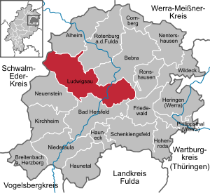
| Location of the municipality of Ludwigsau in the Hersfeld-Rotenburg district | ||
  |
||

Ludwigsau is a large municipality in northeast Hesse in the Hersfeld-Rotenburg district . With 112 km² it is one of the largest municipalities in Hesse.
geography
Geographical location
The community is located on the Fulda in the city triangle of Bad Hersfeld , Bebra and Rotenburg an der Fulda . The municipality marker is on the edge of the Seulingswald and extends along the Rohrbach and its left tributary Endersbach into the eastern Knüllgebirge . The Rohrbach flows into the Fulda near Reilos. The Rohrbachtal is sometimes called Besengrund, which refers to the basket makers and broom makers. These professions have often appeared here in the past centuries.
Neighboring communities
Ludwigsau borders in the north on the municipality of Alheim and the town of Rotenburg an der Fulda , in the east on the town of Bebra and the municipality of Ronshausen , in the southeast on the municipality of Friedewald , in the south on the town of Bad Hersfeld and in the west on the municipality of Neuenstein (all in the district of Hersfeld-Rotenburg) and the municipality of Knüllwald, which is part of the Schwalm-Eder district .
Community structure
The community consists of the 13 districts Beenhausen , Biedebach , Ersrode , Friedlos , Gerterode , Hainrode , Meckbach , Mecklar , Niederthalhausen , Oberthalhausen , Reilos , Rohrbach and Tann .
history

As part of the Hessian territorial reform in 1971/72, two large communities were founded in the Fulda valley north of Bad Hersfeld, in the Besengrund and adjacent valleys. After a short time, these regional authorities and other previously politically independent villages were merged to form the large community of Ludwigsau.
The naming ultimately refers to Landgrave Ludwig I of Hesse , who initiated the construction of two castles named after him - Ludwigseck Castle and Ludwigsaue Castle (built in 1416) - in what is now the municipality. There are no more visible traces of the last-mentioned castle, it stood at the confluence of the Rohrbach and the Fulda.
Church building
In the course of the regional reform in Hesse , the municipality Ludwigseck was created with effect from December 31, 1971 , through the voluntary amalgamation of the formerly independent municipalities of Beenhausen, Ersrode, Hainrode and Oberthalhausen. On the same day, the Ludwigsau community came into being through the voluntary amalgamation of the formerly independent communities of Biedebach, Friedlos, Gerterode, Mecklar and Tann. Friedlos in particular was interested in avoiding forced incorporation into the district town of Bad Hersfeld.
Since Niederthalhausen opposed the amalgamation to the municipality of Ludwigseck, the municipality of Ludwigseck was dissolved again by state law on August 1, 1972 and the associated municipalities and Niederthalhausen as well as Meckbach and Rohrbach were forcibly incorporated into the large municipality of Ludwigsau.
politics
Community representation
The local elections on March 6, 2016 produced the following results, compared to previous local elections:
|
Distribution of seats in the municipal council 2016
A total of 25 seats
|
Parties and constituencies |
% 2016 |
Seats 2016 |
% 2011 |
Seats 2011 |
% 2006 |
Seats 2006 |
% 2001 |
Seats 2001 |
|
|---|---|---|---|---|---|---|---|---|---|---|
| SPD | Social Democratic Party of Germany | 61.5 | 16 | 64.4 | 16 | 61.2 | 19th | 61.7 | 19th | |
| BFL | Citizens for Ludwigsau | 37.4 | 9 | - | - | - | - | - | - | |
| FDP | Free Democratic Party | 1.1 | 0 | - | - | - | - | - | - | |
| CDU | Christian Democratic Union of Germany | - | - | 35.6 | 9 | 38.8 | 12 | 38.3 | 12 | |
| total | 100.0 | 25th | 100.0 | 25th | 100.0 | 31 | 100.0 | 31 | ||
| Voter turnout in% | 61.0 | 59.3 | 61.1 | 63.6 | ||||||
mayor
After the Hessian municipal constitution is the Mayor Chairman of the Municipal Board , the seven volunteers in the community Ludwigsau next to the Mayor Councilor belong. Mayor Wilfried Hagemann ( independent ) was elected on April 22, 2018, with 53.2% of the vote for his first term of office until 2024. Mayor Wilfried Hagemann won the election in a runoff election against Daniel Stange.
coat of arms
Blazon : “The coat of arms is divided diagonally with a blue double wavy line. On the top right a red castle on silver and on the bottom left on silver a red mill wheel ”.
Meaning: The 13 blades of the mill wheel stand for the districts of the community and the castle represents Ludwigseck Castle. The double wavy line stands for the Fulda and the Rohrbach .
Ludwigsau maintains partnerships with the French Changé near Le Mans (since 1997) and with the Thuringian Struth-Helmershof (now part of Floh-Seligenthal ) near Schmalkalden (since 1990).
Culture and sights

These are buildings of historical importance
- Ludwigseck Castle , located between Beenhausen, Ersrode and Sterkelshausen , built around 1400, today owned by von and zu Gilsa and the
- Aviation memorial "In der Nonnenrod".
Natural monuments in the area are
- Nature reserve "Fuldaaue" with renatured gravel excavation (near Mecklar), that
- Landscape protection area Malchustal (near Ersrode),
- Landscape protection area Hauksgrund (near Biedebach) and
- the Gernkopf (417 m above sea level, above Oberthalhausen).
Economy and Infrastructure
traffic
The federal road 27 runs through the districts of Mecklar, Reilos and Friedlos . In the Friedlos district there is a stop on the Bebra – Fulda railway , which Cantus (line R5 Kassel - Bebra - Bad Hersfeld - Fulda in the NVV ) serves . The Mecklar station, which included a larger freight station , was closed in the 1980s. The bus line 320 of the ÜWAG runs regularly between all parts of the municipality of Ludwigsau and the district town of Bad Hersfeld .
Bike trails
The following cycle paths through the districts of Friedlos and Mecklar :
- The Hessian Radfernweg R1 (Fulda-Radweg) leads over 250 km from the heights of the Rhön along the Fulda to Bad Karlshafen on the Weser .
- The D-Route 9 (Weser-Romantic Road) leads from the North Sea via Bremen, Kassel, Fulda and the Taubertal to Füssen in Allgäu (1,197 km).
Established businesses
In the industrial area in the Fuldaaue in Mecklar-Meckbach, the company DHL Supply Chain has been located with its own building since 2007 . In Mecklar-Meckbach there are four gas pipelines nearby and a larger substation is located in the district. As a result, the electricity company Iberdrola decided to build a gas and steam power plant here. In 2011 Ibertrola sold the shares in the Danish energy company Dong Energy . Construction work was originally supposed to start in 2010, but this has been delayed for an indefinite period.
Web links
- Internet presence of the community Ludwigsau
- Ludwigsau, Hersfeld-Rotenburg district. Historical local dictionary for Hessen. In: Landesgeschichtliches Informationssystem Hessen (LAGIS).
- Literature about Ludwigsau in the Hessian Bibliography
Individual evidence
- ↑ Hessian State Statistical Office: Population status on December 31, 2019 (districts and urban districts as well as municipalities, population figures based on the 2011 census) ( help ).
- ↑ a b Federal Statistical Office (ed.): Historical municipality register for the Federal Republic of Germany. Name, border and key number changes in municipalities, counties and administrative districts from May 27, 1970 to December 31, 1982 . W. Kohlhammer GmbH, Stuttgart / Mainz 1983, ISBN 3-17-003263-1 , p. 397 .
- ↑ Law on the reorganization of the districts of Hersfeld and Rotenburg (GVBl. II 330-13) of July 11, 1972 . In: The Hessian Minister of the Interior (ed.): Law and Ordinance Gazette for the State of Hesse . 1972 No. 17 , p. 217 , § 5 ( online at the information system of the Hessian state parliament [PDF; 1,2 MB ]).
- ^ Result of the municipal election on March 6, 2016. Hessian State Statistical Office, accessed in April 2016 .
- ^ Hessian State Statistical Office: Result of the municipal elections on March 27, 2011
- ^ Hessian State Statistical Office: Result of the municipal elections on March 26, 2006
- ↑ Hersfelder Zeitung of January 19, 2016: Citizen list starts in Ludwigsau
- ↑ direct elections in Ludwigsau. In: Statistics.Hesse. Hessian State Statistical Office , accessed in December 2018 .
- ↑ Authorization for power plant granted

Alheim | Bad Hersfeld | Bebra | Breitenbach a. Herzberg | Cornberg | Friedewald | Hauneck | Haunetal | Herring (Werra) | Hohenroda | Kirchheim | Ludwigsau | Nentershausen | Neuenstein | Niederaula | Philippsthal (Werra) | Ronshausen | Rotenburg ad Fulda | Schenklengsfeld | Wildeck
Beenhausen | Biedebach | Ersrode | Friedlos | Gerterode | Hainrode | Meckbach | Mecklar | Niederthalhausen | Oberthalhausen | Reilos | Rohrbach | Fir