
Haunetal
| coat of arms | Germany map | |
|---|---|---|

|
Coordinates: 50 ° 46 ' N , 9 ° 42' E |
|
| Basic data | ||
| State : | Hesse | |
| Administrative region : | kassel | |
| County : | Hersfeld-Rotenburg | |
| Height : | 307 m above sea level NHN | |
| Area : | 54.91 km 2 | |
| Residents: | 2900 (Dec. 31, 2019) | |
| Population density : | 53 inhabitants per km 2 | |
| Postal code : | 36166 | |
| Area code : | 06673 | |
| License plate : | HEF, ROF | |
| Community key : | 06 6 32 008 | |
| Community structure: | 15 districts | |
| Address of the municipal administration: |
Konrad-Zuse-Platz 6 36166 Haunetal |
|
| Website : | ||
| Mayor : | Gerd Lang (independent) | |
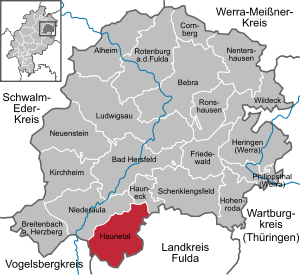
| Location of the community Haunetal in the district of Hersfeld-Rotenburg | ||
  |
||

Haunetal is a market town in the Hersfeld-Rotenburg district in East Hesse .
geography
Geographical location
Haunetal is located in the Vorderrhön, between Bad Hersfeld , about 13 km, and Hünfeld , about 14 km away. The community extends on both sides of the lower reaches of the Haune . It is dominated by the 524 m high Stoppelsberg . It lies between the foothills of the Knüllgebirge , the Rhön and the Vogelsberg . Haunetal is the southernmost municipality in the district.
Neighboring communities
Haunetal borders in the northwest on the municipality of Niederaula , in the northeast on the municipality Hauneck (both in the district of Hersfeld-Rotenburg) in the east on the municipality Eiterfeld , in the south on the municipality Burghaun (both in the district of Fulda ) and in the west on the town of Schlitz ( in the Vogelsbergkreis ).
Community structure
The community consists of the districts Hermannspiegel , Holzheim , Kruspis , Mauers , Meisenbach , Müsenbach , Neukirchen , Oberstoppel , Unterstoppel , Odensachsen , Rhina , Schletzenrod , Starklos , Wehrda and Wetzlos .
history
The districts of Odensachsen and Rhina were first mentioned in a document in 1003, when King Heinrich II divided the realm of Ehringswald (Ehrenvirst) between the Hersfeld and Fulda abbeys .
Some of today's districts already belonged together in the Middle Ages in the rule of Wehrda and later in the district of Neukirchen . Most of the places belonged to the Hersfeld or Fulda abbeys , which they had given to the knights of Romrod, von Trubenbach (later Trümbach), von Otensassen and von Haune (later Hune) as fiefs. The latter were the builders of Hauneck Castle.
The writer Heinrich Ruppel was born in Haunetal in 1886 . At the end of the Second World War, Konrad Zuse's Z4 computer was stored in a barn in the Neukirchen district .

Konrad Zuse founded Zuse KG in the Neukirchen district in 1949 ; In 1957 the company headquarters were relocated to Bad Hersfeld .
Since May 16, 1998 the municipality of Haunetal has been allowed to use the designation market municipality.
- Incorporations
On February 1, 1971, as part of the regional reform in Hesse, the communities of Hermannspiegel, Mauers, Neukirchen, Oberstoppel and Rhina were merged to form the new community of Haunetal in the Hünfeld district. On December 31, 1971, Meisenbach, Müsenbach, Odensachsen, Schletzenrod, Wehrda and Wetzlos (all in the district of Hünfeld) were added. Unterstoppel (district of Hünfeld) and the communities of Holzheim, Kruspis and Starklos, which had previously belonged to the district of Hersfeld , were added to the new district of Hersfeld-Rotenburg by state law on August 1, 1972.
politics
Community representation
The local elections on March 6, 2016 produced the following results, compared to previous local elections:
| Parties and constituencies |
% 2016 |
Seats 2016 |
% 2011 |
Seats 2011 |
% 2006 |
Seats 2006 |
% 2001 |
Seats 2001 |
||
|---|---|---|---|---|---|---|---|---|---|---|
| SPD | Social Democratic Party of Germany | 30.4 | 4th | 46.0 | 11 | 49.2 | 11 | 47.2 | 11 | |
| CDU | Christian Democratic Union of Germany | 38.8 | 6th | 39.0 | 9 | 42.4 | 10 | 40.3 | 9 | |
| GfH | Together for Haunetal | 30.8 | 5 | - | - | - | - | - | - | |
| FWG | Free voter community Haunetal | - | - | 15.0 | 3 | 6.4 | 2 | 9.3 | 2 | |
| FDP | Free Democratic Party | - | - | - | - | 2.0 | 0 | - | - | |
| GREEN | Alliance 90 / The Greens | - | - | - | - | - | - | 3.3 | 1 | |
| total | 100.0 | 15th | 100.0 | 23 | 100.0 | 23 | 100.0 | 23 | ||
| Voter turnout in% | 64.3 | 66.7 | 63.0 | 70.5 | ||||||
mayor
Table of directly elected mayors:
| Surname | from | to | Remarks |
|---|---|---|---|
| Helmut Ruppel | 1993 | 1995 | Elected as CDU candidate, first directly elected mayor |
| Hein-Peter Möller | 1995 | 2011 | elected as an SPD candidate; he was re-elected in 2001 and 2007 |
| Stefan Euler | 2011 | 2014 | elected as a joint candidate by CDU and FWG, retired in 2014 |
| Gerd Lang | 2014 | elected as a non-party candidate |
Culture and sights
Buildings

The Protestant church in Neukirchen was built in the late Gothic style in 1515 on a partially Romanesque substructure. The remarkable interior furnishings include the carved winged altar from 1522 and the font from 1588.
Above Neukirchen and Oberstoppel on the Stoppelsberg , Haunetal's local mountain , is Hauneck Castle , whose building history dates back to the 14th century. The Sinzigburg , west of the Stoppelsberg in the Haunetal, points even further into the past . Not far away, also on the slopes of the stubble mountain, is the natural monument Lange Steine .
Other buildings in the Wehrda district include the Gothic fortified church with old peasant frescoes, Hohenwehrda Castle - built around 1900 by Baron Wilhelm von Kleydorff , today a Hermann-Lietz International School -, the Yellow Castle in Wehrda , the Red Castle in Wehrda - today owned by Johannes Freiherr von Campenhausen - and the Altwehrda castle ruins (presumably the first fortified settlement in a fortified defense tower , built by the von Trumbach knights , later von Stein).
.JPG)
Jewish Cemetery
The 3,896 m² Jewish cemetery of Haunetal is located in the Rhina district . The cemetery is a protected cultural monument and is located about 1 km south of Rhina between the Bebra – Fulda railway line and federal road 27 in the Haune Valley. Another Jewish cemetery is located in the Wehrda district.
Culinary specialties
A culinary specialty from the Haunetal is the Ploatz , a hearty sheet cake made from rye bread dough with different toppings.
Economy and Infrastructure
traffic
The municipality is connected to the supra-regional road network by federal road 27 , which runs through the municipality. The community also has a train station in Neukirchen, on the Bebra – Fulda railway line .
The Public transport is by the North Hessian traffic group guaranteed.
The bus routes are operated by Regionalverkehr Kurhessen . The bus routes mainly provide the connection with Bad Hersfeld.
education
In Neukirchen there is the Haunetal School , a primary school . There is also the Hermann-Lietz-Schule Schloss Hohenwehrda in the Wehrda district .
Sons and daughters of the church
- Friedrich Christian Delius (born February 13, 1943 in Rome) German writer grew up in Wehrda from 1944 to 1958 .
- Heinrich Ruppel (born November 8, 1886 in Neukirchen, † 1974 in Ziegenhain) was a German writer.
- Konrad Zuse (born June 22, 1910 in Deutsch-Wilmersdorf near Berlin; † December 18, 1995 in Hünfeld near Fulda) was a German civil engineer , inventor and entrepreneur .
- Jakob Nussbaum (born January 8, 1873 in Rhina, † December 19, 1936 in Kinneret on the Sea of Galilee) was a painter of German impressionism.
literature
- Harald Neuber: Haunetal history. (with a contribution by Friedrich Krauser) Haunetal 1992, publisher: Community board of the community Haunetal
Web links
- Website of the market town of Haunetal.
Individual evidence
- ↑ Hessian State Statistical Office: Population status on December 31, 2019 (districts and urban districts as well as municipalities, population figures based on the 2011 census) ( help ).
- ^ Municipal reform: mergers and integration of municipalities from January 20, 1971 . In: The Hessian Minister of the Interior (ed.): State Gazette for the State of Hesse. 1971 No. 6 , p. 248 , item 328, para. 28 ( online at the information system of the Hessian state parliament [PDF; 6.2 MB ]).
- ↑ Law on the reorganization of the districts of Hersfeld and Rotenburg (GVBl. II 330-13) of July 11, 1972 . In: The Hessian Minister of the Interior (ed.): Law and Ordinance Gazette for the State of Hesse . 1972 No. 17 , p. 217 , §§ 15 and 17 ( online at the information system of the Hessian state parliament [PDF; 1,2 MB ]).
- ^ Federal Statistical Office (ed.): Historical municipality directory for the Federal Republic of Germany. Name, border and key number changes in municipalities, counties and administrative districts from May 27, 1970 to December 31, 1982 . W. Kohlhammer, Stuttgart / Mainz 1983, ISBN 3-17-003263-1 , p. 398-400 .
- ^ Result of the municipal election on March 6, 2016. Hessian State Statistical Office, accessed in April 2016 .
- ^ Hessian State Statistical Office: Result of the municipal elections on March 27, 2011
- ^ Hessian State Statistical Office: Result of the municipal elections on March 26, 2006
- ↑ Hersfelder Zeitung of January 28, 2016: Together for Haunetal: The name should be the program
- ↑ Data on the direct elections of the mayor in Haunetal

Alheim | Bad Hersfeld | Bebra | Breitenbach a. Herzberg | Cornberg | Friedewald | Hauneck | Haunetal | Herring (Werra) | Hohenroda | Kirchheim | Ludwigsau | Nentershausen | Neuenstein | Niederaula | Philippsthal (Werra) | Ronshausen | Rotenburg ad Fulda | Schenklengsfeld | Wildeck