
Breitenbach am Herzberg
| coat of arms | Germany map | |
|---|---|---|

|
Coordinates: 50 ° 46 ' N , 9 ° 31' E |
|
| Basic data | ||
| State : | Hesse | |
| Administrative region : | kassel | |
| County : | Hersfeld-Rotenburg | |
| Height : | 258 m above sea level NHN | |
| Area : | 42.14 km 2 | |
| Residents: | 1658 (Dec. 31, 2019) | |
| Population density : | 39 inhabitants per km 2 | |
| Postal code : | 36287 | |
| Area code : | 06675 | |
| License plate : | HEF, ROF | |
| Community key : | 06 6 32 004 | |
| LOCODE : | DE BZP | |
| Community structure: | 5 districts | |
| Address of the municipal administration: |
Powerless Strasse 5 36287 Breitenbach a. Herzberg |
|
| Website : | ||
| Mayor : | Volker Jaritz ( independent ) | |
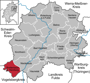
| Location of Breitenbach a. Herzberg in the Hersfeld-Rotenburg district | ||
  |
||


Breitenbach am Herzberg (officially Breitenbach a. Herzberg ) is a municipality in eastern Hesse in the extreme southwest of the district of Hersfeld-Rotenburg .
geography
Geographical location
The community lies at the foot of the Hirschberg (it is also often called Herzberg) and the Rimberg in the southern Knüll Mountains . The districts are spread over the lower Jossatal and its side valleys.
The municipality marker has its lowest point on the Jossa in the Oberjossa district at 234 m above sea level. NN . The highest point is 529 m above sea level. NN on the slopes of the Rimberg.
The community is located between Alsfeld (about 18 km to the west) and Bad Hersfeld (about 20 km to the northeast).
Neighboring communities
Breitenbach borders in the north on the communities Ottrau and Oberaula (both in the Schwalm-Eder district ), in the east on the communities Kirchheim and Niederaula (both in the district of Hersfeld-Rotenburg), in the south on the towns of Schlitz and Grebenau and in the west on the City of Alsfeld (all three in the Vogelsbergkreis ).
Community structure
The community consists of the districts of Breitenbach, Hatterode , Oberjossa , Gehau and Machtlos .
history
The oldest documented mention of the place Breydenbach apud stratam bi dem Herzisberg dates from 1290. This document refers to even older documents. It is therefore assumed that the villages were formed between 400 and 800 years ago.
From 1290 to 1298, Herzberg Castle was built on the " Kurz Hessen " trade route by Heinrich von Romrod . Heinrich received the area around the village as a fiefdom from the Hessian landgraves. In 1372 and 1373, under Friedrich von Herzberg, the castle was a main base of the Knight League of Sterner , who fought against the increasing power of the Hessian landgraves in the last quarter of the 14th century. For several hundred years thereafter, the barons of Dörnberg held the castle and later state fortress of Herzberg.
During the time of the Napoleonic Kingdom of Westphalia (1807-1813) Breitenbach was the capital of the canton of Breitenbach and seat of the justice of the peace .
From 1814, Breitenbach was part of the Electorate of Hesse . After the German War , the place came to the Kingdom of Prussia and its province of Hesse-Nassau in 1867 . In 1928 most of the disbanded estate district of Breitenbach / von Dörnberg was incorporated. After the Second World War, the place to land came Hessen ( Kassel , Kreis Ziegenhain ).
Territorial reform and incorporations
As part of the regional reform in Hesse , the municipalities of Breitenbach am Herzberg, Hatterode and Oberjossa voluntarily joined forces with effect from December 31, 1971 and founded the new large municipality of Breitenbach am Herzberg. Gehau and Machtlos were added by state law on August 1, 1972.
politics
Community representation
The local elections on March 6, 2016 produced the following results, compared to previous local elections:
|
Distribution of seats in the municipal council 2016
A total of 13 seats
|
Parties and constituencies |
% 2016 |
Seats 2016 |
% 2011 |
Seats 2011 |
% 2006 |
Seats 2006 |
% 2001 |
Seats 2001 |
|
| SPD | Social Democratic Party of Germany | 48.7 | 6th | 50.8 | 7th | 50.7 | 8th | 53.9 | 8th | |
| BFH | Citizens' forum Herzberg | 51.3 | 7th | 49.2 | 6th | - | - | - | - | |
| FWG | Free voter community Breitenbach a. H. | - | - | - | - | 49.3 | 7th | 46.1 | 7th | |
| total | 100.0 | 13 | 100.0 | 13 | 100.0 | 15th | 100.0 | 15th | ||
| Voter turnout in% | 53.8 | 53.1 | 61.8 | 62.1 | ||||||
mayor
Volker Jaritz was elected mayor in the runoff election on February 10, 2008 with 65.5% of the votes. His predecessor was Siegfried Steube ( FWG ), who was elected on January 27, 2002 with 71.7% of the vote. Before that, Paul Orth (SPD) held the office. He was elected on March 3, 1996 with a 70.8% share of the vote.
coat of arms
Blazon : “A bar undulated nine times in silver and blue to the left . In front of it a crowned pinnacle tower, divided diagonally to the right by gold and red, with a six-pointed star in confused colors of the tower. "
Meaning: The tower stands for Herzberg Castle. The star on the tower is reminiscent of the Knight's League of Sterner , who had an important base at the castle. The colors gold and red come from the coat of arms of the Barons von Dörnberg , who have owned the castle since 1477.
flag
The flag was approved on November 10, 1988 by the Hessian Ministry of the Interior.
“The flag of the municipality of Breitenbach shows the municipality's coat of arms: on the wavy blue and white divided nine times obliquely to the left, on a tower with five pinnacles divided obliquely by red and gold, a six-pointed star in confused colors; above the tower a golden crown with red and blue gemstones. "
Culture and sights
Buildings
- Herzberg Castle ( Hesse's largest hilltop castle ), on the Hirschberg (formerly Herzisberg)
Regular events
- Burg-Herzberg-Festival (open-air festival, every summer)
- Leprechaun fun fair
- Hutzelfire (burning the Christmas trees)
- Jousting
Sons and daughters of the church
- Franz Ulrich Ries (1695–1755), Protestant theologian and professor at the University of Marburg
- Theodor Christian Friedrich Raydt (1768–1833), lawyer and professor
- Hans Heinrich Wachs (1822–1895), physician, landowner, MdR
- Ludwig Gundlach (1837–1921), administrative officer
Individual evidence
- ↑ Hessian State Statistical Office: Population status on December 31, 2019 (districts and urban districts as well as municipalities, population figures based on the 2011 census) ( help ).
- ^ Breitenbach am Herzberg, Hersfeld-Rotenburg district. Historical local dictionary for Hessen. (As of October 26, 2018). In: Landesgeschichtliches Informationssystem Hessen (LAGIS).
- ↑ Law on the reorganization of the districts of Hersfeld and Rotenburg (GVBl. II 330-13) of July 11, 1972 . In: The Hessian Minister of the Interior (ed.): Law and Ordinance Gazette for the State of Hesse . 1972 No. 17 , p. 217 , § 16 ( online at the information system of the Hessian state parliament [PDF; 1,2 MB ]).
- ^ Federal Statistical Office (ed.): Historical municipality directory for the Federal Republic of Germany. Name, border and key number changes in municipalities, counties and administrative districts from May 27, 1970 to December 31, 1982 . W. Kohlhammer, Stuttgart / Mainz 1983, ISBN 3-17-003263-1 , p. 412 .
- ^ Result of the municipal election on March 6, 2016. Hessian State Statistical Office, accessed in April 2016 .
- ^ Hessian State Statistical Office: Result of the municipal elections on March 27, 2011
- ^ Hessian State Statistical Office: Result of the municipal elections on March 26, 2006
- ^ Approval of a flag of the municipality of Breitenbach a. Herzberg, district of Hersfeld-Rothenburg from November 10, 1988 . In: The Hessian Minister of the Interior (ed.): State Gazette for the State of Hesse. 1988 No. 49 , p. 2611 , item 1164 ( online at the information system of the Hessian state parliament [PDF; 5,6 MB ]).
Web links
- Website of the municipality of Breitenbach am Herzberg
- Breitenbach am Herzberg, Hersfeld-Rotenburg district. Historical local dictionary for Hessen. In: Landesgeschichtliches Informationssystem Hessen (LAGIS).
- Information on the community of Breitenbach am Herzberg. In: Hessisches Gemeindelexikon. HA Hessen Agentur GmbH , 2016.
- Literature about Breitenbach am Herzberg in the Hessian Bibliography
- Link catalog on the topic of Breitenbach am Herzberg at curlie.org (formerly DMOZ )

Alheim | Bad Hersfeld | Bebra | Breitenbach a. Herzberg | Cornberg | Friedewald | Hauneck | Haunetal | Herring (Werra) | Hohenroda | Kirchheim | Ludwigsau | Nentershausen | Neuenstein | Niederaula | Philippsthal (Werra) | Ronshausen | Rotenburg ad Fulda | Schenklengsfeld | Wildeck