Rimberg (Knull)
| Rimberg | ||
|---|---|---|
|
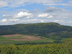
Rimberg from the south, taken from Herzberg Castle |
||
| height | 591.8 m above sea level NHN | |
| location | at Gehau ; District of Hersfeld-Rotenburg , Hessen ( Germany ) | |
| Mountains | Knüllgebirge | |
| Dominance | 10.7 km → Little head in the southwestern Hochknüll | |
| Coordinates | 50 ° 47 '35 " N , 9 ° 28' 1" E | |
|
|
||
| Type | Ridges | |
| rock | Red sandstone | |
| particularities | Rimberg transmitter | |
The Rimberg in the Knüllgebirge ( Knüll ) is 591.8 m above sea level. NHN high, massive mountain near Gehau in the district of Hersfeld-Rotenburg in northern Hesse ( Germany ).
geography
location
The Rimberg is located in the southern end of the Knüllgebirge in the southwest part of the Hersfeld-Rotenburg district between the towns of Alsfeld in the west-southwest and Bad Hersfeld in the east-northeast. Its summit rises around 9 km southwest of Kirchheim , around 4 km northwest of Breitenbach am Herzberg , 1.6 km north-northwest of Gehau , 3.4 km southeast of Görzhain and 1.8 km southwest of Machtlos (as the crow flies ).
The eastern foothills of Rimberg is the Great Bartküppel ( 518.5 m ) to the southeast of it situated little Bartküppel (about 398 m ), its southern slopes of hops stone ( 505.1 m ) and its western foothills of the Glad Phillips (about 530 m ).
The Aula tributary Ibra rises north of the Rimberg , to the northeast the Ibra tributary Powerless Water , south past the Rimberg the Jossa tributary Breitenbach flows in a west-east direction and the Grenff rises northwest of the mountain .
Parts of the bird sanctuary Knüll (VSG no. 5022-401; 269.5731 km² ) extend to the south-westerly through western to north-westerly mountain slopes .
The Rimberg is part of the East Hessian red sandstone clod .
Natural allocation
The Rimberg belongs to the natural spatial main unit group Osthessisches Bergland (No. 35) in the main unit Fulda-Haune-Tafelland (355) to the natural area Ottrauer Bergland (355.0).
Transmitters
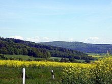
The Rimberg transmitter (approx. 570 m ) has been located on the northwestern part of the Rimberg since 1957 and broadcasts analog radio ( VHF ), digital radio ( DAB + ) and digital television ( DVB-T ).
In addition, there is a transmission mast around 170 m east of the Rimberg Motel-Rasthaus , on the other side of federal motorway 5, on the Großer Bartküppel .
Transport and tourism
The high elevations of the Rimberg are criss-crossed by the rather curvy section Hattenbacher Dreieck - Alsfeld -Ost of the federal motorway 5 , the slopes of which are particularly difficult for trucks . The Rimberg Motel- Rasthaus ( 484 m ), which was built around 500 m east of the mountain peak or directly west of the A 5, can be accessed by car from both directions - coming from the north directly and from the south on a bridge over the motorway to reach.
The Rimberg is forested with beech and spruce . Its summit can be climbed during a walk , including starting at the rest house . From the top you can enjoy the view - for example towards the north to the Hoch knüll .


