Hatterode
|
Hatterode
Municipality of Breitenbach am Herzberg
Coordinates: 50 ° 45 ′ 24 ″ N , 9 ° 30 ′ 11 ″ E
|
|
|---|---|
| Height : | 249 m above sea level NHN |
| Area : | 4.28 km² |
| Residents : | 287 |
| Population density : | 67 inhabitants / km² |
| Incorporation : | December 31, 1971 |
| Postal code : | 36287 |
| Area code : | 06675 |
|
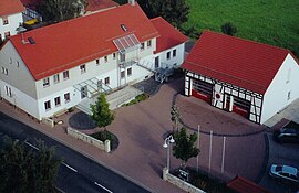
Center of Hatterode from the air
|
|
Hatterode is part of the large community of Breitenbach a. Herzberg in the Hersfeld-Rotenburg district in East Hesse .
geography
The place lies between the towns of Alsfeld and Bad Hersfeld , as the most south-westerly tip of the Hersfeld-Rotenburg district on the border with the Vogelsberg district . The Jossa , a tributary of the Fulda , flows through Hatterode, which is surrounded by forests. Neighboring places along the L3160 are Breitenbach aH in a north-easterly direction and Wallersdorf , a district of Grebenau , in a south-westerly direction. Due to its location on the district boundary, Hatterode is served by both Regionalverkehr Kurhessen GmbH and Verkehrsgesellschaft Oberhessen mbH . The Niederaula – Alsfeld railway line , also called Gründchenbahn, which was closed in 1994 , also ran through the town.
history
Hatterode was first mentioned in a document in 1315 , with its foundation between 900 and 1200. The place was on the then important trade route " Kurz Hessen ". The number of inhabitants 249 has been handed down from 1781, of which 14 were servants and 15 maids. Even then, the 17 farm workers shaped the village character, but millers, tailors, line weavers, a blacksmith and a day laborer also made their living in Hatterode. Around 1950 the population peaked at almost 500.
On December 31, 1971, the municipalities of Hatterode, Breitenbach am Herzberg and Oberjossa merged in the course of the regional reform in Hesse and founded the large municipality of Breitenbach am Herzberg.
politics
Doris Heiderich is the mayor of Hatterode.
Culture and sights
Buildings
Herzberg Castle , the largest hilltop castle in Hesse, is only a few kilometers north-west of the village .
The Protestant church in Hatterode is the oldest church in the larger community. It was recently renovated as part of a village renewal program and received, among other things, a new church tower.
There are also numerous well-preserved half-timbered houses in Hatterode that are listed as historical monuments.
societies
- Fraternity
- Volunteer firefighter
- Friends of Social Life
- Gymnastics group
- Hunting association
- Hiking enthusiasts
Regular events
- Jerusalem festival
- People's hiking day
- Tent fair
power supply
The residents of Hatterode have relied heavily on renewable energy in recent years. Photovoltaic and solar systems are increasingly shaping the townscape. In addition, a biogas plant was put into operation, which among other things supplies some households with heating energy.
Individual evidence
- ^ Hatterode, Hersfeld-Rotenburg district. Historical local dictionary for Hessen. (As of December 9, 2014). In: Landesgeschichtliches Informationssystem Hessen (LAGIS).
- ↑ Page no longer available , search in web archives: Hattenrode on the website of the municipality of Breitenbach am Herzberg, accessed in January 2016.
- ^ Federal Statistical Office (ed.): Historical municipality directory for the Federal Republic of Germany. Name, border and key number changes in municipalities, counties and administrative districts from May 27, 1970 to December 31, 1982 . W. Kohlhammer, Stuttgart / Mainz 1983, ISBN 3-17-003263-1 , p. 412 .
Web links
- District Hatterode. In: Internet presence. Municipality of Breitenbach am Herzberg
- Hatterode. Local history, information. In: www.hatterode.de. Private website
- Hatterode, Hersfeld-Rotenburg district. Historical local dictionary for Hessen. In: Landesgeschichtliches Informationssystem Hessen (LAGIS).


