
Vogelsbergkreis
| coat of arms | Germany map |
|---|---|

|

Coordinates: 50 ° 38 ' N , 9 ° 24' E |
| Basic data | |
| Existing period: | 1972– |
| State : | Hesse |
| Administrative region : | to water |
| Administrative headquarters : | Lauterbach |
| Area : | 1,458.99 km 2 |
| Residents: | 105,643 (Dec. 31, 2019) |
| Population density : | 72 inhabitants per km 2 |
| License plate : | VB |
| Circle key : | 06 5 35 |
| NUTS : | DE725 |
| Circle structure: | 19 municipalities |
| Address of the district administration: |
Goldhelg 20 36341 Lauterbach |
| Website : | |
| District Administrator : | Manfred Görig ( SPD ) |
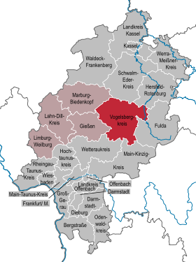
| Location of the Vogelsbergkreis in Hesse | |
  |
|
The Vogelsbergkreis is a district in the administrative district of Gießen in the region of Central Hesse or Upper Hesse , East Hesse . The district town is Lauterbach .
geography
.JPG)
location
The name of the district is given by the Vogelsberg , a volcano that has been extinct for millions of years and is therefore partially eroded and is located in the south of the district. Its highest point is the baptismal font (773 m), east of Schotten. The northern district area still extends into the landscape of the Schwalm .
Neighboring areas
The Vogelsbergkreis borders in a clockwise direction in the north, starting with the districts of Schwalm-Eder-Kreis , Hersfeld-Rotenburg , Fulda , Main-Kinzig-Kreis , Wetteraukreis , Gießen and Marburg-Biedenkopf .
history
At the beginning of the 19th century, today's district area mainly belonged to the Landgraviate of Hesse-Darmstadt , later the Grand Duchy of Hesse . In addition, there were several small territorial rulers such as the Riedesel barons of Eisenbach and the imperial counts of Schlitz . Since the mediatization in 1806 the area belonged almost completely to the Grand Duchy of Hesse, only the villages Berfa , Hattendorf and Lingelbach belonged to the district of Ziegenhain before the territorial reform in the 1970s and the localities of the former court Katzenberg belonged to the Electorate of Hesse until 1866 . Until the middle of the 19th century, the administrative structures at the district level changed frequently.
In 1832 the district of Alsfeld was founded, which changed its borders several times in the course of history, the last time in 1938. In 1852, the district of Lauterbach was formed. This circle was also changed in its boundaries in 1938.
As part of the regional reform in Hesse , the new Vogelsbergkreis with the district town of Lauterbach was created on August 1, 1972. It was formed from:
- the district of Alsfeld
- the Lauterbach district
- the city of Schotten from the Büdingen district
- the municipalities of Berfa , Hattendorf and Lingelbach from the district of Ziegenhain , which were incorporated into the city of Alsfeld
- the community Weidenau from the district of Fulda , which was incorporated into Freiensteinau
- the municipality of Radmühl from the district of Gelnhausen , which was incorporated into Freiensteinau and
- the community of Reinhards from the district of Schlüchtern , which was incorporated into Freiensteinau .
Population development
| year | Residents | source |
|---|---|---|
| 1972 | 112,400 | |
| 1980 | 109,500 | |
| 1990 | 113,700 | |
| 2000 | 118,496 | |
| 2010 | 109,757 | |
| 2015 | 105,522 |
politics
District council
The local elections on March 6, 2016 produced the following results, compared to previous local elections:
| Diagram showing the election results and the distribution of seats | |
|---|---|
| Nominations | % 2016 |
Seats 2016 |
% 2011 |
Seats 2011 |
% 2006 |
Seats 2006 |
% 2001 |
Seats 2001 |
|
|---|---|---|---|---|---|---|---|---|---|
| CDU | Christian Democratic Union of Germany | 35.5 | 22nd | 35.1 | 21st | 40.3 | 25th | 37.7 | 23 |
| SPD | Social Democratic Party of Germany | 31.8 | 19th | 34.3 | 21st | 37.4 | 23 | 39.0 | 24 |
| FREE VOTERS | FREE VOTERS | 10.6 | 6th | 9.7 | 6th | 7.6 | 5 | 9.4 | 6th |
| GREEN | Alliance 90 / The Greens | 7.7 | 5 | 12.8 | 8th | 5.3 | 3 | 5.2 | 3 |
| AfD | Alternative for Germany | 5.8 | 4th | - | - | - | - | - | - |
| FDP | Free Democratic Party | 4.6 | 3 | 4.5 | 3 | 5.3 | 3 | 5.7 | 3 |
| THE LEFT. | THE LEFT. (2006: DIE LINKE.WASG ) | 4.0 | 2 | 3.6 | 2 | 1.8 | 1 | - | - |
| REP | The Republicans | - | - | - | - | 2.4 | 1 | 3.0 | 2 |
| total | 100.0 | 61 | 100.0 | 61 | 100.0 | 61 | 100.0 | 61 | |
| Voter turnout in% | 57.0 | 53.3 | 53.2 | 58.2 | |||||
District administrators
- Roland Manz (State Commissioner), August 1, 1972 to December 20, 1972
- Jochen Zwecker (SPD), January 1973 to April 1987 (except for a six-month phase in early 1985)
- Gerulf Herzog (CDU), January 1985 to July 1985
- Hans-Ulrich Lipphardt (SPD), June 1, 1987 to 2000
- Rudolf Marx (CDU), 2000 to June 2012
- Manfred Görig (SPD), since June 2012
Coat of arms, flag and banner
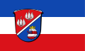
Hoist flag

Banner flag

|
|
Blazon : “Divided diagonally to the left by a silver strip; Above in red two natural silver Turkish lilies , below in blue the lion's head, divided three times by silver and red, with a golden crown. " |
|
Justification of the coat of arms: The Turkish lilies are taken from the old district coat of arms of Lauterbach and symbolize the nature park Hoher Vogelsberg , the lion stands for the Landgraviate of Hesse or its successor states, which ruled most of today's district area. It can also be found in the coat of arms of the city of Alsfeld.
The coat of arms was awarded on July 26, 1978. |
District Committee
The district committee has 15 members and is the top management body of the district administration. Chairman is the full-time District Administrator Manfred Görig (SPD); the 14 district councilors are volunteers.
District Youth Parliament
In addition to the district council, there has been a district youth parliament (KJP) in the Vogelsbergkreis since 1992, which has had the right to propose and speak in the district council since 1999. A KJP member in the youth welfare committee has been allowed to participate in decisions with one vote since 1997. Active and passive right to vote all young people are from the seventh class until their 18th birthday. The KJP consists of a total of 27 members from the 19 towns and cities of the Vogelsberg district. How many MPs each city / municipality has depends on the number of inhabitants:
- up to 6000 inhabitants one MP
- two MPs up to 12,000 inhabitants
- over 12,000 residents three MPs.
Partner circles
One of the partners is the Oberhavel district .
economy

The rural Vogelsbergkreis has the lowest population density (72 inhabitants per square kilometer) and at the same time the third largest area of all Hessian districts. Although the district is dominated by agriculture , due to the structural change since the 1950s, only a small fraction of the labor force is currently employed in the primary sector . 43.7% of the area of the Vogelsbergkreis is agricultural land. Of this, 52.4% is cultivated as grassland , making the Vogelsbergkreis the highest proportion of grassland in Hesse.
The medium - sized industry (paper, packaging, metal construction, tools, wood, furniture, clothing) is predominantly located in the few towns in the district, particularly in Alsfeld and Lauterbach. Of around 36,000 employees in the Vogelsberg district, around 16,000 are commuters to other districts. Tourism is an important branch of the economy . The Hoher Vogelsberg Nature Park was founded back in 1956, making it the second oldest nature park in Germany (after the Lüneburg Heath Nature Park ). It covers the area around the Oberwald and extends beyond the Vogelsbergkreis to the neighboring districts of the district of Gießen, Main-Kinzig-Kreis and Wetteraukreis. The volcano cycle path leads through the eastern part of the district on a former railway line .

The use of wind energy to generate electricity in inland Germany began in the Vogelsbergkreis . The district is one of the particularly windy locations within Hesse . In 1990/91 the Vogelsberg wind energy park in the municipality of Grebenhain was the first German wind park in the low mountain range and at the same time the first wind park in Hesse, initially for test purposes. The first commercial wind farm projects in Hesse were implemented in 1993/94 in the Vogelsberg communities of Feldatal and Ulrichstein. Of the around 700 wind turbines built in Hessen by the end of 2012 , around 200 are in the Vogelsberg district.
In the future atlas 2016 , the Vogelsbergkreis took 278th place out of 402 districts, municipal associations and urban districts in Germany, making it one of the regions with a "balanced risk-opportunity mix" for the future.
traffic

The federal motorway 5 ( Frankfurt - Bad Hersfeld ) opens up the district area for motorway traffic via the Homberg (Ohm) and Alsfeld West and Alsfeld Ost junctions. The federal highways B 62 , B 254 and B 275 as well as several state roads and district roads serve regional traffic in the Vogelsbergkreis .
The Vogelsbergkreis can be reached by train via the ICE station in Fulda with the single-track Vogelsbergbahn Fulda – Lauterbach – Alsfeld – Mücke– Gießen, which was expanded in 2011 . ( RMV line RB 45, formerly RB 35 in the Rhein-Main transport association ). At the railway junction in Giessen, there are further connections to Frankfurt and the Rhine-Main area. Another double-track expansion of the line in sections is required. The low development with rail traffic (only one railway line in the district area) is related to the difficult topography in the Vogelsberg massif and correlates with the decreasing population density in the region; there is no direct rail connection to the neighboring districts in the north or to the Frankfurt metropolitan area. Bus traffic within the district and to the neighboring regions enables mobility by public transport.
There is a connection to the Kinzig valley via the federal road 276 and the Vogelsberger Südbahnradweg .
Communities
(Residents on December 31, 2019)
|
|
Parishes in the district   |
.jpg)
License Plate
On February 12, 1979, the Vogelsbergkreis was assigned the new distinctive sign VB . Until then, the distinctive signs ALS and LAT, valid since July 1, 1956 in the districts of Alsfeld and Lauterbach, continued to apply in their respective sub-districts of the Vogelsberg district newly formed on August 1, 1972.
Until the 1990s, vehicles from the Alsfeld district received license plates with the letter pairs AA to ZZ and the numbers from 1 to 99 as well as the letter pairs PA to ZZ and the numbers from 100 to 999. The vehicles in the Lauterbach district received license plates with one letter and the numbers up to 999 as well as with the letter pairs AA to NZ and the numbers from 100 to 999.
The abbreviation VB is assigned to this day.
literature
- Georg Eurich: The Vogelsberg in the heart of Germany . Wartberg Verlag, Gudensberg-Gleichen 2000, ISBN 3-86134-938-8 .
- Hannelore Vietze: "The future will be terrible ...". Everyday history of National Socialism in the Vogelsberg. Edited and edited by Christine Wittrock. CoCon, Hanau 2005, ISBN 3-937774-15-7 .
Web links
_104.jpg)
- Website of the Vogelsbergkreis
- Vogelsbergkreis. Historical local dictionary. In: Landesgeschichtliches Informationssystem Hessen (LAGIS).
- Vogelsberg: A region introduces itself
- Link catalog on the subject of the Vogelsbergkreis at curlie.org (formerly DMOZ )
Individual evidence
- ↑ Hessian State Statistical Office: Population status on December 31, 2019 (districts and urban districts as well as municipalities, population figures based on the 2011 census) ( help ).
- ^ Federal Statistical Office (ed.): Historical municipality directory for the Federal Republic of Germany. Name, border and key number changes in municipalities, counties and administrative districts from May 27, 1970 to December 31, 1982 . W. Kohlhammer, Stuttgart / Mainz 1983, ISBN 3-17-003263-1 , p. 385 f .
- ↑ Vogelsberg district. Historical local dictionary. In: Landesgeschichtliches Informationssystem Hessen (LAGIS).
- ↑ Law on the reorganization of the Alsfeld and Lauterbach districts of July 11, 1972, GVBl. I p. 215
- ↑ Statistical Yearbook for the Federal Republic of Germany 1974
- ^ A b Michael Rademacher: German administrative history from the unification of the empire in 1871 to the reunification in 1990. Vogelsbergkreis. (Online material for the dissertation, Osnabrück 2006).
- ↑ Hessian State Statistical Office
- ↑ Population in the administrative districts on September 30, 2010 and population processes in the 3rd quarter of 2010. Hessian State Statistical Office, archived from the original on May 10, 2011 ; accessed on May 31, 2019 .
- ↑ Population in the administrative districts on June 30, 2015 and change in population in the 2nd quarter of 2015. Hessian State Statistical Office, archived from the original on March 24, 2016 ; accessed on May 31, 2019 .
- ^ Hessian State Statistical Office: Results of the district elections of 2016 and 2011
- ^ Hessian State Statistical Office: Results of the district elections of 2011 and 2006
- ^ Hessian State Statistical Office: Results of the district elections of 2006 and 2001
- ^ Hessian State Statistical Office: Results of the district elections of 2001 and 1997
- ↑ General - District Youth Parliament. In: www.kjp-vb.de. Archived from the original on June 23, 2016 ; accessed on June 23, 2016 .
- ↑ Vogelsbergkreis press office ( Memento of February 4, 2012 in the Internet Archive ) (PDF; 2.4 MB). Retrieved July 7, 2012
- ↑ Vogelsberg Consult (PDF; 7.3 MB). Retrieved July 7, 2012
- ↑ Vogelsbergkreis press office ( Memento of February 4, 2012 in the Internet Archive ) (PDF; 2.4 MB). Retrieved July 7, 2012
- ↑ Central Hesse energy portal . Retrieved July 7, 2012
- ↑ Wind power in the Vogelsberg district . Retrieved July 7, 2012
- ↑ Federal Renewable Portal . Retrieved April 5, 2013
- ↑ Zukunftsatlas 2016. Archived from the original ; accessed on March 23, 2018 .
- ↑ Greens call for the expansion of the Vogelsbergbahn , Oberhessische Zeitung , accessed on August 31, 2018.
- ↑ Public transport in the ZOV
- ↑ Hessian State Statistical Office: Population status on December 31, 2019 (districts and urban districts as well as municipalities, population figures based on the 2011 census) ( help ).
Counties: Bergstrasse | Darmstadt-Dieburg | Fulda | Casting | Gross-Gerau | Hersfeld-Rotenburg | Hochtaunuskreis | Kassel (Country) | Lahn-Dill-Kreis | Limburg-Weilburg | Main-Kinzig-Kreis | Main-Taunus-Kreis | Marburg-Biedenkopf | Odenwaldkreis | Offenbach (State) | Rheingau-Taunus-Kreis | Schwalm-Eder district | Vogelsbergkreis | Waldeck-Frankenberg | Werra-Meißner district | Wetteraukreis
Independent cities: Darmstadt | Frankfurt am Main | Kassel | Offenbach am Main | Wiesbaden