
District of Kassel
| coat of arms | Germany map |
|---|---|

|

Coordinates: 51 ° 19 ′ N , 9 ° 29 ′ E |
| Basic data | |
| Existing period: | 1821– |
| State : | Hesse |
| Administrative region : | kassel |
| Administrative headquarters : | kassel |
| Area : | 1,292.92 km 2 |
| Residents: | 236,764 (Dec. 31, 2019) |
| Population density : | 183 inhabitants per km 2 |
| License plate : | KS, HOG, WOH |
| Circle key : | 06 6 33 |
| NUTS : | DE734 |
| Circle structure: | 28 municipalities |
| Address of the district administration: |
Wilhelmshöher Allee 19–21 34117 Kassel |
| Website : | |
| District Administrator : | Uwe Schmidt ( SPD ) |
| Location of the district of Kassel in Hesse | |
 .svg) |
|
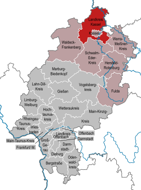
The district of Kassel is located in the administrative district of the same name in Kassel in northern Hesse . The north of the district is rural, while the south forms the suburbs of the independent city of Kassel , which is almost completely surrounded by the district. The district administration is also located in Kassel .
geography
location
In broad terms, the district lies between the Diemel in the north, the Weser and Fulda in the east and extends as far as the vicinity of the Eder in the south, with the area of the independent city of Kassel in the south-east being left out as an enclave. Nevertheless, it is the namesake of the district and the seat of the district administration. Enumerated from west to east and from north to south are the following landscapes in the district of Kassel: the old forest ; the Wolfhagener Becken and the Elbergrund ; in the center the Habichtswälder Bergland with the high grass as the summit ( 614.8 m ); the Hofgeismarer Rötsenke and the Kassel basin ; of the Weser-Leine-Bergland scoring Reinhardswald west of the Weser and the north end of the Bramwaldes east of it; east of Kassel parts of the Kaufunger Forest and the Söhre .
Neighboring areas
The district borders clockwise in the northwest, beginning with the Höxter district in North Rhine-Westphalia , the Northeim and Göttingen districts in Lower Saxony and the Werra-Meißner district , the Schwalm-Eder district and the Waldeck-Frankenberg district in Hesse. The Lower Saxony district of Holzminden is close to the border , but because of a tip of North Rhine-Westphalia it does not border on the district of Kassel.
prehistory
The Wartberg culture (also Wartberg culture or Wartberg group) is a culture of the late Neolithic (late Neolithic), named after its eponymous place of discovery, the Wartberg, located in northern Hesse near the Kirchberg district of Niedenstein. The main focus of the Wartberg culture was u. a. in northern Hesse. The gallery graves that can be found in the area around Züschen , southwest of Kassel , are evidence of the culture and are also called "Hessian-Westphalian stone boxes ".
history
Large parts of today's district area are congruent with the core settlement area of the Germanic Chatti , the ancestors of the Hessians . In the early Middle Ages, today's district area was split up and disputed between different rulers ( Landgraviate Hessen , Kurmainz , Hochstift Paderborn , Kurköln and Duchy of Braunschweig ). But almost the entire area came under unified sovereignty very soon after the Landgraviate of Hesse was constituted and then later to the Landgraviate of Hesse-Kassel , whose ruler was made electoral in 1803 . In 1866 the Electorate of Hesse was annexed by Prussia and united with the Duchy of Nassau and the Free City of Frankfurt to form the Province of Hesse-Nassau . In Kurhessen, now the Kassel making, in 1821 the district of Kassel, and the circles were Hofgeismar and Wolfhagen formed.
In 1866, the Wilhelmshausen community moved from the Hofgeismar district to the Kassel district. The community of Großenhof moved from the Kassel district to the Wolfhagen district in 1896 and became part of the Martinhagen community there .
On April 1, 1899, the district of Kassel ceded the municipality of Wehlheiden to the independent city of Kassel, as did the municipalities of Bettenhausen , Kirchditmold , Rothenditmold and Wahlershausen on April 1, 1906 and the municipalities of Harleshausen , Niederzwehren , Nordshausen , Oberzwehren on June 1, 1936 , Waldau and Wolfsanger .
At the beginning of the 1970s, the external borders of the Kassel district changed several times:
- On December 1, 1970, the Hohenkirchen community in the Hofgeismar district was merged with the Mönchehof community to form the new Espenau community in the Kassel district.
- Also on December 1, 1970, the municipality of Wickenrode from the district of Witzenhausen was merged with the municipality of Helsa to form the new municipality of Helsa-Wickenrode in the district of Kassel.
- On December 31, 1971, the municipality of Martinhagen in the district of Wolfhagen was incorporated into the municipality of Hoof in the district of Kassel.
As part of the Hessian district reform , with effect from August 1, 1972, the districts of Hofgeismar and Kassel with most of the district of Wolfhagen and the municipality of St. Ottilien of the district of Witzenhausen were merged to form the new district of Kassel. The town of Volkmarsen in the Wolfhagen district fell to the Waldeck district .
The first change of area in the district since the 1970s is the merger of the municipalities of Oberweser and Wahlsburg to form the municipality of Wesertal on January 1, 2020 .
Population development
The population development is characterized by two contradicting developments: While communities in the Kassel area (or Altkreis Kassel) are recording an increase in population, the number of inhabitants on the outskirts of the district continues to decrease, especially around Hofgeismar and Wolfhagen.
| year | Residents | source |
|---|---|---|
| 1871 | 39,560 | |
| 1900 | 53,597 | |
| 1910 | 48.193 | |
| 1925 | 59,234 | |
| 1933 | 64.022 | |
| 1939 | 50,379 | |
| 1950 | 72.211 | |
| 1960 | 74,300 | |
| 1970 | 98,300 | |
| 1980 | 221.100 | |
| 1990 | 231.200 | |
| 2000 | 245.997 | |
| 2010 | 237,460 | |
| 2015 | 233,623 | |
| 2019 | 237.032 |
politics
District council
The local elections on March 6, 2016 produced the following results, compared to previous local elections:
Distribution of seats

Election results
| Nominations | % 2016 |
Seats 2016 |
% 2011 |
Seats 2011 |
% 2006 |
Seats 2006 |
% 2001 |
Seats 2001 |
|
|---|---|---|---|---|---|---|---|---|---|
| SPD | Social Democratic Party of Germany | 44.3 | 36 | 48.0 | 39 | 51.5 | 42 | 55.0 | 44 |
| CDU | Christian Democratic Union of Germany | 22.8 | 19th | 26.2 | 21st | 31.3 | 25th | 30.4 | 25th |
| AfD | Alternative for Germany | 11.0 | 9 | - | - | - | - | - | - |
| GREEN | Alliance 90 / The Greens | 8.6 | 7th | 14.5 | 12 | 8.1 | 7th | 7.6 | 6th |
| FW | Free voters in the Kassel district | 5.3 | 4th | 3.2 | 3 | - | - | - | - |
| THE LEFT. | THE LEFT. | 3.9 | 3 | 3.0 | 2 | 4.4 | 3 | - | - |
| FDP | Free Democratic Party | 4.1 | 3 | 2.3 | 2 | 4.6 | 4th | 4.7 | 4th |
| Animal welfare party | Human Environment Animal Welfare Party | - | - | 1.6 | 1 | - | - | - | - |
| PIRATES | Pirate Party Germany | - | - | 1.3 | 1 | - | - | - | - |
| Independent | Independent Democrats | - | - | - | - | - | - | 2.3 | 2 |
| total | 100.0 | 81 | 100.0 | 81 | 100.0 | 81 | 100.0 | 81 | |
| Voter turnout in% | 51.9 | 52.5 | 50.2 | 58.0 | |||||
District administrators
- 1832–1849 Karl Wilhelm Philipp Bockwitz (district councilor, 1st district official)
- 1854–1868: Friedrich Bernstein
- 1868–1881: Ernst von Weyrauch
- 1881–1907: Julius von Dörnberg
- 1907–1931: Gottfried Rabe von Pappenheim
- 1931–1933: Karl Ohle
- 1933–1934: Fritz Lengemann (NSDAP)
- 1934–1937: Walter Schultz
- 1937–1945: Konrad Fischer (District Administrator) (NSDAP)
- 1945–1946: Gottfried Rabe von Pappenheim
- 1946–1951: Karl Herrmann
- 1951–1972: Josef Köcher ( SPD )
- August 1, 1972 - December 18, 1974: Herbert Günther (SPD)
- December 19, 1974 - February 6, 1975: Gerhard Arnold (SPD), first district member
- February 7, 1975 - February 6, 1981: Gerhard Arnold (SPD)
- February 7, 1981 - June 30, 1991: Willi Eiermann (SPD)
- July 1, 1991 - June 30, 2009: Udo Schlitzberger (SPD)
- since July 1, 2009: Uwe Schmidt (SPD)
badges and flags
| Banner, coat of arms and flag | |

|
|

|
|
|
|
Blazon : "In the shield, divided by blue and gold, on the left diagonally, the gold-crowned and armored, growing Hessian lion , below three fan-shaped green oak leaves, on which two black wolf- rods, onebehind the other,are placed on the left." |
| Reasons for the coat of arms: The Hessian lion symbolizes belonging to Hesse (royal seat Kassel), the oak leaves point to a scenic event in the Reinhardswald, according to which St. Boniface is said to have felled the oak of the god Donar in order to demonstrate the superiority of Christianity. The oak was also in the coat of arms of the old district of Hofgeismar. The Wolfsangeln stand for the old district of Wolfhagen, whose earlier coat of arms showed a black wolf, which was a special coat of arms of the Wolfhagen rule. |

Description of the flag : "The flag shows the coat of arms of the district on a flag strip divided by red, white and red in a ratio of 1: 3: 1 in the upper half of the white central strip."
In April 1952, the Kassel district was granted the right to use a coat of arms according to the draft submitted by the Hessian State Ministry. The coat of arms and flag were approved on May 9, 1975 by the Hessian Minister of the Interior.
Partner regions
- Waldviertel , Austria (State of Lower Austria )
- Forlì-Cesena Province , Italy ( Emilia-Romagna Region )
- Csepel Island, Hungary
- Yaroslavl , Russia ( Yaroslavl Oblast )
- Bistrița-Năsăud , Romania
- Dane County , United States ( Wisconsin )
Tourism and sightseeing

Tourism has developed into an important branch of the economy for the Kassel district in recent years. In particular, the cultural landscape with historical half-timbered villages, which has grown over centuries, as well as the extensive natural landscapes of the Reinhardswald and the Habichtswälder Bergland are visited by numerous tourists.
Numerous characters and places from the fairy tales of the Brothers Grimm have their origins in the area around Kassel. This is how the fairy tale of Sleeping Beauty on the Sababurg in Reinhardswald, that of Rapunzel on the Trendelburg, is located. This is why the Kassel district is also marketed as the “Grimm Brothers' fairy tale land”. The region forms the center of the German Fairy Tale Route .
With the Kneipp spa town of Naumburg , the mineral spa Bad Emstal and the brine spa Bad Karlshafen, there are three recognized spa towns in the Kassel district.
In addition to the city of Kassel with the Karlsaue and Bergpark parks, the Kassel district is also strongly represented in the European Garden Heritage Network with three gardens , these are the parks of the palaces Schloss Wilhelmsthal (Calden) and Schloss Escheberg and Sababurg .
Active tourism has been growing for a number of years. The cycle paths along the Weser , Fulda and Diemel , the Hessian long-distance cycle path R4 and the Herkules-Wartburg cycle path cross the district. The range of long-distance hiking trails includes the Ederseeweg , Grimmsteig , Habichtswaldsteig , Herkulesweg , Kassel-Steig , Märchenlandweg and Weserberglandweg . In numerous places there are short circular hiking trails with eco-paths , on which many sights are explained with information boards and also on a website. Canoe tours on Fulda , Weser and Diemel and excursion steamer trips on the first two rivers are also popular.
In 2011 there were 163 statistically recorded overnight accommodations with a total of 12,011 beds in the Kassel district. This accounted for 300,568 guest arrivals and 730,310 overnight stays, which corresponds to an average length of stay of 2.4 days. Most of the guests come from Germany , 9.9% came from abroad. The main countries of origin were the Netherlands , the United Kingdom and the Scandinavian countries .
Economy and Transport
In the Future Atlas 2016 , the district of Kassel was ranked 111th out of 402 districts, municipal associations and independent cities in Germany, making it one of the regions with “future opportunities”. In the 2019 edition, it improved to 90th place out of 401, making it one of the regions with “high future prospects”.
Streets
The federal highways 7 ( Würzburg- Kassel- Hanover ), 44 (Kassel- Dortmund ) and 49 Kassel- Neuental (Hesse) run through the district . Furthermore, several federal roads open up the district area, including the B 7 , B 83 , B 251 and the former B 520 as well as many state and district roads .
Public transport
The district of Kassel is part of the North Hessian Transport Association (NVV).
The high-speed line Hanover – Kassel – Würzburg , which has a stop at Wilhelmshöhe station in Kassel , runs through the district area . Several railway lines run in a star shape from Kassel main station through the district and beyond its borders:
- the Kassel – Warburg railway with the stations Kirchditmold , Harleshausen , Jungfernkopf , Vellmar -Obervellmar , Mönchehof , Immenhausen , Grebenstein , Hofgeismar , Hümme and Liebenau in the north to Warburg (East) Westphalia,
- the Hannöversche Südbahn, for example with Vellmar-Niedervellmar , Fuldatal- Ihringshausen in the north,
- the Bebra-Baunatal-Guntershausen railway line with, among other things, the Kassel-Wilhelmshöhe , Oberzwehren , Baunatal- Rengershausen train stations in the south-southeast to Bebra and
- the Main-Weser-Bahn, for example, with the stations Kassel-Wilhelmshöhe , Oberzwehren , Baunatal- Rengershausen and Baunatal-Guntershausen in a south-west direction to Marburg and Gießen . Both of the latter connections run together between Guntershausen and Kassel.
In addition, from the above results Kassel-Warburg railway branching railway Volkmarsen-Vellmar-Obervellmar among others Vellmar- Obervellmar , Heckershausen , Weimar , Fürstenwald , Zierenberg , Oberelsungen , Altenhasungen and Wolf Hagen in northwest towards Volkmarsen . The trains run with a connection to Korbach .
On the northern edge, the district is served by the Solling Railway in Bad Karlshafen and the Göttingen – Bodenfelde railway in Vernawahlshausen . Before that, there was a branch and a direct connection between Hümme and Bad Karlshafen via the Carlsbahn until 1966 .
Since August 2007 the RegioTram Kassel , some of whose trains also run on the Kassel tram , has been connecting Kassel's city center with Warburg (Westphalia), Hofgeismar, Melsungen, Schwalmstadt / Treysa and Wolfhagen. The city of Baunatal can be reached by the Kassel tram lines 5 and 7, the municipalities of Kaufungen , Helsa and Hess. Lichtenau on the former Waldkappeler Bahn by line 4. Since October 2011, line 1 has been running from Kassel to the city of Vellmar.
In addition, numerous bus routes connect the municipalities of the district with each other and with the city of Kassel.
See also: Railways in Northern Hesse , RegioTram Kassel
Airport
With the Kassel-Waldau airfield , there was an airfield with international connections since 1924. In 1970 this was closed after the opening of the new Kassel-Calden airfield; This airport was replaced by a new building in April 2013 at a geographically slightly relocated location and has been known as Kassel Airport since 2015 .
Communities
(Residents on December 31, 2019)


|
|
The population development is very heterogeneous: while Baunatal and Lohfelden have shown constant population growth over the years, the remaining places recorded a population decline.
Former parishes
The following list contains all the former municipalities of the Kassel district and the dates of their incorporations:
License Plate
On July 1, 1956, the district was assigned the distinguishing mark KS when the vehicle registration number that is still valid today was introduced . It is still issued today. Since January 2, 2013, due to the license plate liberalization, the distinguishing marks HOG (Hofgeismar) and WOH (Wolfhagen) have been available. Since 2016, no distinction has been made between the district and the city of Kassel in the sequence of numbers and letters.
Web links
- Website of the district of Kassel
- District of Kassel. Historical local dictionary. In: Landesgeschichtliches Informationssystem Hessen (LAGIS).
- Adventure region Kassel-Land - tourism website
- Link catalog on the Kassel district at curlie.org (formerly DMOZ )
Individual evidence
- ↑ Hessian State Statistical Office: Population status on December 31, 2019 (districts and urban districts as well as municipalities, population figures based on the 2011 census) ( help ).
- ^ Ulrich Reuling : Administrative division 1821–1955. (PDF) In: Historical Atlas of Hesse. Landesgeschichtliches Informationssystem Hessen (LAGIS), p. 176 , accessed on March 19, 2016 .
- ^ Federal Statistical Office (ed.): Historical municipality directory for the Federal Republic of Germany. Name, border and key number changes in municipalities, counties and administrative districts from May 27, 1970 to December 31, 1982 . W. Kohlhammer, Stuttgart / Mainz 1983, ISBN 3-17-003263-1 , p. 400 f .
- ↑ HNA on July 25, 2013: "Kassel district loses 474 inhabitants"
- ^ The municipalities and manor districts of the Hesse-Nassau province and their population in 1871
- ↑ a b c d e f g h i Michael Rademacher: German administrative history from the unification of the empire in 1871 to the reunification in 1990. Kassel district. (Online material for the dissertation, Osnabrück 2006).
- ↑ Statistical Yearbook for the Federal Republic of Germany 1972
- ↑ Hessian State Statistical Office.
- ↑ Population in the administrative districts on September 30, 2010 and population processes in the 3rd quarter of 2010. Hessian State Statistical Office, archived from the original on May 10, 2011 ; accessed on May 31, 2019 .
- ↑ Population in the administrative districts on June 30, 2015 and change in population in the 2nd quarter of 2015. Hessian State Statistical Office, archived from the original on March 24, 2016 ; accessed on May 31, 2019 .
- ↑ Hessian State Statistical Office (Statistics Hessen)
- ^ Hessian State Statistical Office: Results of the district elections of 2016 and 2011
- ^ Hessian State Statistical Office: Results of the district elections of 2011 and 2006
- ^ Hessian State Statistical Office: Results of the district elections of 2006 and 2001
- ^ Hessian State Statistical Office: Results of the district elections of 2001 and 1997
- ↑ 2006 election: WASG
- ↑ Granting of the right to use a coat of arms to the district of Kassel, administrative district of Kassel from April 2, 1952 . In: The Hessian Minister of the Interior (ed.): State Gazette for the State of Hesse. 1952 No. 16 , p. 293 , item 373 ( online at the information system of the Hessian state parliament [PDF; 2.1 MB ]).
- ^ Approval of a coat of arms and a flag of the district of Kassel, administrative district of Kassel from May 9, 1975 . In: The Hessian Minister of the Interior (ed.): State Gazette for the State of Hesse. 1975 No. 22 , p. 973 , point 757 ( online at the information system of the Hessian state parliament [PDF; 4.1 MB ]).
- ↑ Eco-Pfade website
- ↑ Guests and overnight stays in tourism (preliminary results), for calendar year in the December report.
- ↑ Zukunftsatlas 2016. Archived from the original ; accessed on March 23, 2018 .
- ↑ PROGNOS future atlas. Handelsblatt, accessed on December 10, 2019 .
- ↑ Hessian State Statistical Office: Population status on December 31, 2019 (districts and urban districts as well as municipalities, population figures based on the 2011 census) ( help ).
- ↑ HNA of July 13, 2012: "Population in the district is shrinking - Lohfelden increases by 158 inhabitants"
- ↑ District of Kassel. Historical local dictionary. In: Landesgeschichtliches Informationssystem Hessen (LAGIS).
Counties: Bergstrasse | Darmstadt-Dieburg | Fulda | Casting | Gross-Gerau | Hersfeld-Rotenburg | Hochtaunuskreis | Kassel (Country) | Lahn-Dill-Kreis | Limburg-Weilburg | Main-Kinzig-Kreis | Main-Taunus-Kreis | Marburg-Biedenkopf | Odenwaldkreis | Offenbach (State) | Rheingau-Taunus-Kreis | Schwalm-Eder district | Vogelsbergkreis | Waldeck-Frankenberg | Werra-Meißner district | Wetteraukreis
Independent cities: Darmstadt | Frankfurt am Main | Kassel | Offenbach am Main | Wiesbaden
Eschwege | Frankenberg | Fritzlar-Homberg | Fulda | Gelnhausen | Hanau | Hersfeld | Hofgeismar | Hünfeld | Kassel | Marburg | Melsungen | Rotenburg | Schluechtern | Waldeck | Witzenhausen | Wolfhagen | Goat grove
Disbanded in 1932 : Fritzlar | Gersfeld | Homberg | Kirchhain | Released in 1932 : Grafschaft Schaumburg
Disbanded in 1942 : District of the Eder | District of Eisenberg | District of Twiste | Released in 1944 : Reign of Schmalkalden