Heckershausen
|
Heckershausen
community Ahnatal
Coordinates: 51 ° 21 '59 " N , 9 ° 25' 26" E
|
|
|---|---|
| Height : | 215 m above sea level NHN |
| Area : | 6.42 km² |
| Residents : | 2071 (1970) |
| Population density : | 323 inhabitants / km² |
| Incorporation : | August 1, 1972 |
| Postal code : | 34292 |
| Area code : | 05609 |
Heckershausen is the eastern part of the municipality of Ahnatal in the northern Hessian district of Kassel .
geography
The village is located in the district of Kassel northeast of the Habichtswald , a few kilometers northwest of Kassel and directly east of Weimar . It is located a few hundred meters east of Rasenallee , the historic traffic route between Kassel and Wilhelmsthal Castle , which is about 3 km northwest of Heckershausen and belongs to the municipality of Calden .
The Ahne flows through Heckershausen and is framed by the Staufenberg ( 361 m above sea level ) in the north and the Firnskuppe ( 313.9 m ) in the south. To the north of the village rises the Stahlberg ( 348 m ), a southwestern extension of the Staufenberg, where a barbecue area with a hut has been built.
history
1106 is the first documentary mention of the place "Hekereshusun" in a list of goods Breviarium Sancti Lulli of the Hersfeld Abbey . A first pastor was named in 1357. In 1585 31 households are recorded. The church patronage belonged to the Kassel Martinsstift and had been a landgrave since the Reformation .
On August 1, 1972, the two were previously independent municipalities Heckershausen and Weimar, in the course of administrative reform in Hesse , powerful state law for greater community Ahnatal together .
In 2006, Heckershausen was 900 years old. This anniversary was celebrated from May 19 to June 6, 2006 as part of a festival week.
Historical place names
In documents that have survived, Heckershausen was mentioned under the following names (the year it was mentioned in brackets): Hekereshusun (1106); Heggereshusun (1107), (Hersfeld); Hekkereshusun (1146), (Hersfeld); Höckershausen (1505); Heckershausen
Attractions
- The nave of the church in the middle of the village (left) was rebuilt in historicizing forms in the 19th century . The weather vane on the pommel of the dome's choir tower, which is probably medieval, is dated to 1886. The bell-shaped projectile, transformed into the oblong octagon, is slated.
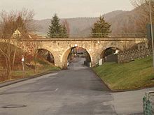
- The 3-arched railway bridge made of ashlar masonry , over which the railway line mentioned below leads, stands on the southern edge of the village.
traffic
- Heckershausen has two stops on the Volkmarsen – Vellmar-Obervellmar railway line . Since 2007 the RegioTram has been running on this route from Wolfhagen to the Kassel tram network with stops at both stops; a trip to Kassel takes about 15 minutes.
- Heckershausen also has a bus connection which so far has served the towns of Weimar, Kammerberg, Heckershausen, Vellmar and Kassel. Two buses have been running in Ahnatal since December 2006: NVV line 49 connects the Ahnatal districts of Heckershausen and Weimar, and line 48 runs from Ahnatal through Vellmar and Fuldatal to Kassel.
- In particular, the A 44 and the federal highways 7 , 83 and 251 , which cross the Kassel area, for example, can usually be reached in a short time.
literature
- Carl Wilhelm Hermann Hochhuth: Statistics of the Protestant Church in the administrative district of Cassel , p. 53.
- Heinrich Reimer: Historical local dictionary for Kurhessen , p. 214 f.
- Literature about Heckershausen in the Hessian Bibliography
Web links
- Website of the municipality of Ahnatal
- Heckershausen in its history. In: www.geschichte-ahnatal.de. Heckershausen history working group for trace security, archived from the original on April 15, 2017 .
- Heckershausen, Kassel district. Historical local dictionary for Hessen. In: Landesgeschichtliches Informationssystem Hessen (LAGIS).
Individual evidence
- ↑ a b c d Heckershausen, Kassel district. Historical local dictionary for Hessen. (As of March 18, 2016). In: Landesgeschichtliches Informationssystem Hessen (LAGIS).
- ↑ Law on the reorganization of the districts of Hofgeismar, Kassel and Wolfhagen (GVBl. II 330-17) of July 11, 1972 . In: The Hessian Minister of the Interior (ed.): Law and Ordinance Gazette for the State of Hesse . 1972 No. 17 , p. 225 , § 8 ( online at the information system of the Hessian state parliament [PDF; 1,2 MB ]).
- ^ Federal Statistical Office (ed.): Historical municipality directory for the Federal Republic of Germany. Name, border and key number changes in municipalities, counties and administrative districts from May 27, 1970 to December 31, 1982 . W. Kohlhammer GmbH, Stuttgart and Mainz 1983, ISBN 3-17-003263-1 , p. 401 .


