
Ancestor (Fulda)
| Ancestor, Ahna | ||
 The Ahna at the canteen ( ⊙ ; right) of the University of Kassel |
||
| Data | ||
| Water code | DE : 42958 | |
| location | District of Kassel and independent city of Kassel , North Hesse ( Germany ) | |
| River system | Weser | |
| Drain over | Fulda → Weser → North Sea | |
| source | in the Hohen Habichtswald on Essigberg west of Kassel 51 ° 19 ′ 7 ″ N , 9 ° 21 ′ 2 ″ E |
|
| Source height | approx. 575 m above sea level NHN / | |
| muzzle | in Kassel in the Fulda coordinates: 51 ° 19 ′ 3 " N , 9 ° 30 ′ 56" E 51 ° 19 ′ 3 " N , 9 ° 30 ′ 56" E |
|
| Mouth height | approx. 135 m above sea level NHN / | |
| Height difference | approx. 440 m | |
| Bottom slope | approx. 21 ‰ | |
| length | 21.1 km | |
| Catchment area | 41.332 km² | |
| Drain |
MQ |
296 l / s |
| Left tributaries |
Geilebach ( Geile → Döll → Mombach ) (this and others see below ) |
|
| Right tributaries |
Dorfbach (Servitutgraben) (this and others see below ) |
|
| Big cities | kassel | |
| Small towns | Vellmar | |
| Communities | Ahnatal , Habichtswald | |

The Ahne (also called Ahnebach and Ahna or Ahnabach ) is a 21.1 km long, northwest and left tributary of the Fulda . It flows in the district of Kassel and in the independent city of Kassel in northern Hesse ( Germany ).
geography
course
The river originates as Ahn e in High Habichtswald . Its source is in the Habichtswald Nature Park about 0.6 km northeast of the Habichtswald telecommunications tower on the Essigberg (approx. 597.5 m above sea level ) and 0.8 km northwest of the highest point of the Great Stone Pile ( 597 m ). It is located a few hundred meters outside the Kassel urban area in the south-eastern part of the Habichtswald community, hidden in the forest at an altitude of almost 575 m .
Shortly after its source, the ancestor flows east-north-east along the chestnut avenue lined with horse chestnuts, past Hute and pasture areas that are between the wooded mountains Wuhlhagen ( 561.7 m ) in the north and Großer Steinhaufen ( 561.7 m ) in the south and the Kassel Hercules stretch; The latter stands about 1.3 km southeast of the brook in the Bergpark Wilhelmshöhe . The brook passes the Sichelbach basin , located around 500 m south-southeast , the main reservoir of the Kassel water features , to which a 2.2 km long moat leads from the brook . North of the Sichelbach basin, the ancestor crosses the Habichtswaldsteig and, for the first time, the Märchenlandweg . From there, a short section of the Kassel-Steig leads along the stream to the restaurant Zum Silbersee (approx. 470 m ).
Ahne upper reaches near the source at Essigberg ( ⊙ )
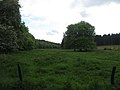
Hute and pasture areas on the Ahne upper reaches at Kastanienallee ( ⊙ )

Ahne upper course above the restaurant Zum Silbersee ( ⊙ )
.jpg)
.jpg)

Below the restaurant, the ancestor runs through wooded areas to the north. In the Habichtswald it partially forms the natural border between Kassel- Harleshausen and the Habichtswald community and flows quite steeply downhill through a deeply cut valley. The stream passes basalt and limestone formations, old wells and the remains of a long-disused mine , in which brown coal was once extracted, either directly or at a short distance . In addition, the ancestor flows past a basalt mine. From this area of the stream it is not far to the ring wall of the former Igelsburg and to the nearby Silbersee .
At the old restaurant Ahnetal , which stands at the exit of the forest near a tight curve at the junction ( 335 m ) of the district road 21 leading to Weimar from the federal road 251 ( Brilon- Kassel), the ancestor finally leaves the densely wooded area of Harleshausen High Habichtswaldes; it crosses under the B 251 and flows north-east. Below the edge of the forest, she is accompanied for a short distance by the Märchenlandweg. Then it flows through the Ahnatal with the municipality of Ahnatal approximately to the east. The ancestor passes further wells and the Bühl elevation ( 322.5 m ) with the Bühl mountain lake 400 m to the southeast and takes up the stream from the Steinfeldwiesen .
To the southeast of the Ahnataler district of Weimar, the Ahne passes under the Volkmarsen – Vellmar-Obervellmar railway , after which the Kleine Ahne , which rises between the Erlenloch and the Erlenlochswiesen and is fed by the Silberborn , flows into it. She leaves the Habichtswald Nature Park at the bridge over the railway line. Shortly afterwards the brook crosses a footbridge with a parallel ford (approx. 235 m ). After crossing under the K 30 (Weimar– Heckershausen ), it flows past the bridge mill to the southeast of the Weimar locality of Kammerberg .
Then the Ahne crosses under the Rasenallee ( Landesstraße 3217) and runs eastwards through the Ahnataler district Heckershausen, which lies between the Firnskuppe ( 313.9 m ) in the south and the Stahlberg ( 347.9 m ) with the Staufenberg ( 361.2 m ) beyond it m ) lies in the north. Up to the center of the village, on the creek bank at about 215 m above sea level, it has overcome a height difference of 360 m.
A little below Heckershausen, the ancestor reaches Vellmar and the Obervellmar district . Before reaching the built-up areas of the small town and immediately after taking in the Entenbach coming from the northwest, it flows along the K 31 (Heckershausen− Vellmar ) through a brook tunnel under the route of the Kassel – Warburg railway line . From then on, it will be accompanied by the Märchenlandweg hiking trail until it reaches its mouth . After flowing through the Ahnepark , the brook crosses under a common section of federal roads 7 and 83 (approx. 178 m ). A little further east-southeast of it, it passes under the Halle-Kassel railway in Niedervellmar and at the same time the high-speed line Hanover – Kassel – Würzburg (approx. 171 m ).
From there on, but no later than the city limits of Vellmar and Kassel, which are located by the brook at around 162.5 m above sea level, the flowing water is called Ahn a . Beyond this border, below the waiting mountain ( 229.1 m ), where the brook flows through an extensive, undeveloped lowland , branches off the artificially created Mühlgraben . It runs west to south-west along the wooded western slope of the Warteberg and, after a length of about 750 m, flows its water back into the Ahna at a height of about 157 m, a little below the Paris mill , which was built around 1850 to supply the Philippinenhof colony . With a drop height of 8 m, a turbine in the Paris mill generates electricity for the mill operation. The Mittelbach , which comes from the junction of Berliner Straße from Holländische Straße (B 7/83) and is mostly dry, joins southwest below the Warteberg . A little further south of it the Ahna is from out of the district of Kassel Jungfernkopf coming Jungfernbach fed, the out of the sewers of Bunsenstraße comes.
Then the Ahna runs in a south-easterly direction, mostly canalized, parallel to Bunsen Strasse and a little east of Holländische Strasse through built-up areas of Kassel, flowing through various parts of the city or forming their borders. It flows between the vocational school center in the west and the Kassel Clinic on a hill in the east and the University of Kassel in the south along the eastern border of the Nordstadtpark (laid out 1999 to 2004; approx. 145 m ), which will in future be followed by the Ahnapark directly in the south (not to be confused with the above-mentioned ancestral park in Vellmar). At the southeast corner of the Nordstadtpark , the lower course of the Geilebach flows into the Mombach - immediately after leaving the Mombachstrasse sewer system .
After crossing the university campus and the nearby shortly after passing under the Federal Highway 3 ( Weserstraße corner Kurt-Wolters-Straße - Schützenstraße ; 140.1 m ) and the trail Herkulesweg opens the Ahna near the small barrages -Insel Finkenherd , next to the Kassel- lock with roller weir stands between the harbor and Fulda bridges near Fulda kilometer 27.3 at a height of around 135 m in the Fulda .
Catchment area and river system
The catchment area of the Ahne or Ahna is 41.332 km². The river system includes, viewed downstream, with orographic allocation (l = left-hand side, r = right-hand side), length of the river and its mouth with ancestral brook kilometers and - if known - the size of the catchment area of these rivers :
- Bach from the Steinfeldwiesen (r; 0.9 km), far below the Ahnetal restaurant (at 14.4 km)
-
Kleine Ahne (r; 2.4 km), southeast of Weimar (at km 13.15)
- Silberborn (l; 1.25 km), below the Erlenloch meadows (at Kleine-Ahne-km 1.15)
-
Dorfbach (or Servitutgraben ; 1; 4.8 km), between Weimar and Heckershausen below the Brückenmühle (at 11.7 km); 8.5 km²
- Erlebach (l; 2.1 km), in Weimar (near Dorfbach-km 1.25)
- Bach am Stahlberg (l; 0.6 km), in Weimar (near Dorfbach-km 10.9)
- Entenbach (l; 0.6 km), between Heckershausen and Vellmar directly above the brook tunnel of the Kassel – Warburg railway line (at 9.2 km)
-
Rainbach (r; 1.6 km; with Firnsbach 3.1 km long), in Obervellmar below the outdoor pool (at km 8.65)
- Hühnerkampsgraben (Quellbach, l; 1.8 km), near the Beulchen hill south of Heckershausen (on Rainbach-km 1.6)
- Firnsbach (Quellbach: r; 1.5 km), near the Beulchen hill south of Heckershausen (on Rainbach-km 1.6)
- Rinnbach (r; 1.9 km), directly west of Obervellmar in the sewer system below or above the embankment tunnel of the Volkmarsen – Vellmar-Obervellmar railway and the Kassel – Warburg railway ; near the grill hut Obervellmar (near Rainbach-km 0.4)
-
Elsche (or Ehlsche ; l; 2.7 km), in Obervellmar near the Bahnhofstrasse / Holländische Strasse intersection (at 8.2 km)
- Mittelbach (r; 0.6 km), before Obervellmar below the Steimel (near Elsche-km 0.95)
- Bach vom Hopfenberg (1 km), in Niedervellmar near the Grundweg (at 6.55 km)
- Bach of Frommershausen (r; 0.6 km), below Frommershausen; east of the junction Sendeweg from Hopfenbergstraße (at Bach-vom-Hopfenberg-km 0.65)
- Brook on the border of Vellmar and Kassel (right; 0.8 km), on the border of Vellmar-Niedervellmar and Kassel- Philippinenhof-Warteberg southeast of the Wiesenstrasse (at 4.5 km)
- Mittelbach (r; 1.4 km), on the border between Niedervellmar and Kassel- North Holland, east of Niedervellmarer Strasse (at km 4.4)
- Jungfernbach (r; 2.9 km), in Kassel on the outskirts of Philippinenhof-Warteberg / North Holland near the intersection of Niedervellmarer Straße / Bunsenstraße (at km 3.8)
- Mommenröder Graben (l; 1.1 km), in Kassel also on the Philippinenhof-Warteberg / North Holland border on Bunsenstrasse (at 3.4 km)
- Quellgraben (1; 0.9 km), along Quellbachweg and Quellhofstraße ; in Kassel in the district of North Holland on Bunsenstrasse / Rothfelsstrasse (at km 2.35)
- Geilebach ( Geile → Döll → Mombach ; r; approx. 8.5 km), in Kassel on the border of the district of North Holland / Fasanenhof on Mombachstrasse (at 1.5 km)
Natural allocation
The ancestor or Ahna originates and flows initially in the natural spatial main unit group West Hessisches Bergland (No. 34), in the main unit Habichtswälder Bergland (342) and in the subunit Hoher Habichtswald and Langenberg (342.0) in the natural area Hoher Habichtswald (342.00). It then flows through the east of the Dönbergpass (342.30) natural area, which is part of the Dörnberg and Schreckenberge subunit (342.3 ). Then, shortly after leaving the wooded area, the stream enters the main unit West Hessian Basin (343), in which it runs up to its confluence with the Fulda in the subunit Kassel Basin (343.3).
Protected areas
The upper reaches of the Ahne up to the Ahnetal restaurant on the B 251 are located in the fauna-flora-habitat area Habichtswald and Seilerberg near Ehlen (FFH no. 4622-302; 29.1936 km² ). From the city limits of Vellmar and Kassel, the Ahna lower reaches are mostly and the confluence with the Fulda in the landscape protection area of the city of Kassel ( CDDA no. 378517; 1995; 19.8386 km²).
Kassel sea sand
At the ancestor or ahna you can find the Kassel sea sand with fossil shells, fish vertebrae and shark teeth. About 28 million years ago the landscape was washed over by the water of a sea. When the surface of the earth rose after about 4 million years, the water gradually drained away. This was followed by further uplifts and subsidence, as well as volcanic eruptions, the leaked lava of which covered the landscape and marine deposits protectively. Later on, among other things, deposits were washed away on the ancestor.
history
Between Heckershausen and Weimar, a pedestrian bridge ( ⊙ ) near Kreisstrasse 30 (Weimar – Heckershausen) about 100 m south of the bridge mill collapsed on March 12, 2010 when a 1.5-ton tractor tug across the wooden bridge an apparently rotten wooden beam drove. On August 19, 2010, a new bridge, 6.7 m long and 2.5 m wide, made of fully galvanized and painted steel beams on the old has abutments of reinforced concrete set. The flooring of the bridge, which is provided with metal railings, consists of bongossi wooden boards.
Transport links and hiking

The ancestor or Ahna passes under inter alia, the Federal Highway 251 (Wolfhager road) on the northern slope of the High Habichtswald the Rasenallee ( national road 3217) between Weimar and Heckershausen, a common and as a motor road -developed portion of the main roads 7 and 83 (Dutch road) in Vellmar, another common section of both streets (Kurt-Wolters-Straße) in Kassel and, a few meters below it, the B 3 (Weserstraße) in Kassel.
The ancestor crosses under the Volkmarsen – Vellmar-Obervellmar railway line near Weimar . Shortly after the influence on Vellmar, it passes under the Kassel – Warburg railway line . In the city, the brook crosses the Halle-Kassel railway and at the same time the high-speed line Hanover – Kassel – Würzburg .
In the Hohe Habichtswald, the ancestor crosses under the Habichtswaldsteig and, for the first time, the Märchenlandweg , which leads north below the Sichelbach basin over a wooden bridge, and is accompanied there for a short distance by the Kassel-Steig . Within the forest you can hike through the deeply cut and shady valley on the upper reaches of the Ahne between the restaurants Zum Silbersee and Ahnetal on paths and trails. There a path leads partly directly through the creek bed, over small creek islands and in three places over wooden bridges. From Weimar through Heckershausen to Vellmar, the approximately 9 km long Ahne Eco Path runs along the Ahne . Outside the Habichtswald, below the B 251 in the Ahnetal municipality, paths lead along the stream through agricultural areas and then through the Ahnatal district of Heckershausen to Vellmar , where you can walk through the Ahnepark . From there, through the Kassel, located a little below the park, at the area where the brook influences the big city, first on the west to south-west slope of the Warteberg (along the Mühlgraben of the Paris mill ) and then further along the brook to the confluence of the Ahna and the Fulda Fairyland path.
Web links
References and comments
- ↑ a b c d e f g h i j k l m n Water map service of the Hessian Ministry for the Environment, Climate Protection, Agriculture and Consumer Protection ( information )
- ↑ a b c d e f g h i j k Topographical map Stadtatlas Kassel ( M. = 1: 10.000), Ed . : Stadt Kassel, Vermessung und Geoinformation, 2009
- ↑ a b c The values for the catchment area and runoff are somewhat larger in real terms, as the lower reaches of the Fulda are combined.
- ↑ Altitude based on contour lines of various topographical maps, scale 1: 50,000, determined in position comparison with the waterway map service of the Hessian Ministry for the Environment, Climate Protection, Agriculture and Consumer Protection ( information )
- ↑ Der Mühlenladen , accessed on February 8, 2015, at pariser-muehle.de
- ↑ Nordstadtpark, Kassel ( memento from February 6, 2013 in the web archive archive.today ), brief information and photos, accessed on October 11, 2012, from cms.latz-riehl-partner.de
- ↑ a b Waters II. And III. Order / drainage ditches , map of the city of Kassel ( size = 1: 10,000), publisher : Kartographie Stadt Kassel, surveying and geoinformation, 2007
- ↑ The Silberborn can be noisy referenced map waters II. And III. Order / drainage ditches can also be viewed as the left source arm of the Kleine Anhne .
- ^ Hans-Jürgen Klink: Geographical land survey: The natural space units on sheet 112 Kassel. Federal Institute for Regional Studies, Bad Godesberg 1969. → Online map (PDF; 6.9 MB)
- ↑ Map services of the Federal Agency for Nature Conservation ( information )
- ↑ Kasseler Meeressand , in Eco Path Ahne , accessed on October 15, 2015, on eco-pfade.de
- ↑ Article Pedestrian bridge collapsed in Ahnatal , from March 15, 2010, accessed on October 11, 2012, on hna.de.
- ↑ Article Community wants to check bridges , with the location of the accident site, March 16, 2010, accessed on October 11, 2012, on hna.de.
- ↑ Article Steel beams replace wooden beams , August 20, 2010, accessed on October 11, 2012, at hna.de.
- ↑ Eco Path Ahne , accessed on October 15, 2015, from eco-pfade.de