
Kilometrage
As Kilometrierung one continuous meter and referred km -counting along a traffic route , such as a road, a railway or a river. The center line is used as the so-called traffic axis. With the help of the kilometer it is possible to clearly name any point on a route, for example "kilometer 120". In this way, locations “on the same level” (cross line to the axis) can be described well.
Compared to the usual position information using coordinates (geographical longitude and latitude), the kilometrage is only one-dimensional. This means that each point on the axis only needs a number for its position along the line, e.g. B. "Kilometer 120.5". For the exact location of a point next to the axis, you need a distance and direction (left / right) in addition to the kilometers, for example "5 meters to the left of kilometer 22.545".
Definitions
The equally common notion of stationing or Baustationierung is in most cases at the (sub) sections during construction and traffic planning related. The stationing is often based on locally favorable conditions with regard to its zero point (e.g. crossing point of another structure, switch start in the reconstruction section, etc.).
Often there are breaks in the kilometrage when the length of the route is changed, but no new kilometer classification is made. This would not only require moving the kilometer markers along the entire route, but is also hardly feasible because the kilometrage is mentioned in a wide variety of documents and many kilometers are contractual bases. In this case, one speaks in Germany of a kilometer change , kilometer jump or kilometer jump ; especially in the railway sector of excess length or short length . In Austria and Switzerland one speaks of an error profile .
Flowing waters
The nautical metering of rivers is used to orient shipping and is done with milestones or kilometer boards that are attached to the bank. They are also known as river kilometers . Mostly, the kilometers are upstream, i.e. from the mouth to the source. For example, the Danube kilometrage has its zero point on the Black Sea . The Rhine , which begins at kilometer 0 in Constance , is an exception .
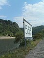
Rhine kilometer 555 below the Loreley rock near St. Goarshausen
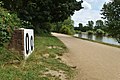
Main kilometer 0.0 at the mouth


Difference between stationing and mileage
In addition to mileage, there is also what is known as stationing in hydrography . It runs upstream in all bodies of water (in central parts of Europe), including rivers and river sections that are kilometers downstream. The Rhine, which is also stationed downstream , is an exception here .
Individual river systems and rivers
Danube

On the Danube, the kilometering and stationing are identical. The international mileage has its zero point at the confluence with the Black Sea .
Tributaries:
Correspondingly, the Inn and Salzach , March and Thaya , Waag ( Váh ), Drau (Drava), Theiss (Tisza, Tisa) and Save (Sava) lines begin at the confluence with the Danube and the higher-ranking tributary .
Rhine
The kilometers of the Alpine Rhine begin at the confluence of the Vorder and Hinterrhein in Reichenau and end at Lake Constance . Below the Obersee of Lake Constance there is an international kilometer, which also serves as an international station. It starts in the Seerhein at the Rhine bridge in Constance and ends behind Rotterdam . Overlapping there is the Swiss GEWISS addressing, which begins in Basel on the border to France and runs from there upwards through Lake Constance to the confluence of the Vorder and Hinterrhein in the sense of a classic stationing.
Tributaries:
- The kilometers of the Main begin at the confluence with the Rhine.
- The Moselle begins at its confluence with the Rhine.
- The Lahn is kilometered partly downstream and partly upstream. The zero point is on the former Prussian - Hessian state border six kilometers below Gießen.
Elbe
The Czech kilometering has undergone a historical development: under Austrian rule , the Elbe was only kilometers from the mouth of the Moldau at Mělník to the German border. With the expansion of navigability, kilometers were added from the same starting point upstream to the dam in Chvaletice .
In 1997 a uniform kilometering was proclaimed, upstream with zero at the lower end of the old Austrian. However, it was never signposted in the area. A similar, also not signposted, kilometer allocation has been used internally for technical systems since 1968–1972.
Since January 1, 2009 , the international mileage adopted by the EU in 2005 has officially been in effect in the Czech Republic and begins at the mouth of the Elbe near Cuxhaven .
Czech and German kilometers overlap in the 3.43 km long area in which the border runs in the middle of the river. The Czech one runs on the right bank of the Elbe to the Schmilka / Hřensko border crossing . The German kilometers begin on the left bank of the Elbe (mouth Gelobtbach ). It also includes the Outer Elbe and ends in the open North Sea at kilometer 769.40 . The kilometering at kilometer 121 has an error from the one around 1880, which the kingdoms of Prussia and Saxony carried out for themselves, so that suddenly there was one kilometer too much at the state border at that time. Therefore, after kilometer 121, kilometer 121A follows. In 1933/34 the short litter at Vockerode was straightened and shortened by about one and a half kilometers. The kilometrage has not been changed, so that now 500 meters after 250 kilometers already follows 252 kilometers.
Tributaries:
- In nautical terms, the Havel belongs to two different waterways, the Untere Havel waterway and the Havel-Oder waterway . Both are kilometers from the Spandau lock , the lower Havel without the Potsdam Havel arch .
Weser
The Weser is kilometers downstream. The zero point of the inland waterway is at the confluence of the Werra and Fulda rivers in Hann. Münden . The kilometers of the Unterweser have their zero point a few meters downstream of the Wilhelm Kaisen Bridge in Bremen , where the Great Weser Bridge marked the limit of shipping for centuries .
Tributaries:
- The line has its zero point at the mouth of the Innerste at Sarstedt . From there, the traditionally navigable part is kilometers downstream to the confluence with the Aller, the non-traditionally navigable part is upstream.
railroad


Railways have a continuous kilometer or hectometer. For this purpose, stones or boards are placed along the route for local identification. The kilometrage runs along a defined reference axis and is, for example, in the middle of the track on a single-track route. The beginning and end of the kilometer allocation usually form train stations or route branches. For example, the center of a reception building (Germany) or reception building (Austria) can be used as the start of a kilometer reading, as this is a fixed reference point.
If there are interruptions in the continuity of a kilometer (e.g. by shortening or lengthening a railway line in the course of a construction project), then in Germany one speaks of a kilometer change or kilometer jump. When the railway line is shortened, the length is incorrect; when the line is lengthened, the length is excessive.
In Austria, when the continuity is interrupted, a distinction is made between a mileage break and an error profile. If one route leads into another, a change in the kilometer system takes place at a specified point (e.g. the beginning of the turnout of the branch point), which is called the kilometer break.
The incorrect length resulting from construction activity shortening the route is compensated for by a negative error profile, and excess length resulting from construction activity extending the route is compensated for by a positive error profile.
Examples of notation:
Flaw profile (−80 m)

Error profile (+30 m)

When specifying the error profile, the sign describes the route-shortening effect of the correction (negative error profile) or the route-lengthening effect of the correction (positive error profile).
Streets

The local marking of distance markers has already been used in ancient times (for example on Roman roads ) with the help of stones placed on the side. Today, the kilometering is usually only carried out on regional roads or important road connections and is practiced almost all over the world. The use of stones is declining in many places and instead the kilometers are marked with the help of boards, signs, posts or signs on the roadside. The zero point of the kilometrage can be, for example, the beginning of a road connection (usually an intersection or confluence within a town) or a national border.
Since continuous kilometering results in double kilometers or missing kilometers in the event of a change in the length of the route (for example due to construction work), Germany has switched to providing route sections with a section number and stationing them separately. So-called network nodes, i.e. nodes between classified streets, serve as the zero point. The stationing is marked every 200 or 500 meters by a station sign , depending on the state . The stationing is usually from west to east and from south to north.

In Austria, mileage signs are made of retroreflective foil with a transparent blue print on aluminum sheet U and upright tube made of aluminum or galvanized steel. On small district streets, boards between the whole kilometers are usually only white with black imprint, narrow in portrait format and on a wooden post about 7 centimeters wide and 2.5 centimeters thick. Above the number of kilometers, and under a horizontal line the number of meters (2, 4, 6, or 8). The blue and white kilometers on motorways only take place every 0.5 kilometers.
The picture from Austria shows the double stationing on a state road B (formerly and commonly known as federal road) at a kilometer jump, which is caused by lengthening a route and the like. a. was created by the construction of a bypass. The two panels have slightly different contours and fonts. The order of the kilometer tables in this area is now in this example ( B 178 ):
... 4.4 / 4.6 / 4.8 / 5.0 / 5.2 / 5.326 at the same time D 4.6 / D 4.8 / D 5.0 / D 5.2 / 5.4 ...
literature
- Harri Tritter: Kilometer stones: A consideration of the kilometering of the German railway lines , yearbook for railway history 17, 1985, pp. 85–111.
Web links
- Mileage of the German autobahns
- Kilometers in the Salzburg road information system ( Memento from August 18, 2010 in the Internet Archive )
- Further information on road kilometers
Individual evidence
- ↑ Ril 883.0010 1 (3)
- ↑ a b track and construction survey; Kilometers of railway lines - Guideline 883.0010 (PDF; 155 KiB)
- ↑ Railway kilometer system. Retrieved May 18, 2010 .
- ↑ Page no longer available , search in web archives: Swiss Federal Office for the Environment FOEN
- ↑ Distance table for the Moselle between Koblenz and Thionville (PDF; 49.9 KiB)
- ↑ Foldable boat wiki: kilometer table km 121 - 121A
- ↑ Paddelsport.de: The Elbe-Kilometer 121 ( Memento of the original from February 20, 2015 in the Internet Archive ) Info: The archive link was inserted automatically and has not yet been checked. Please check the original and archive link according to the instructions and then remove this notice.
- ↑ Paddelsport.de: Vockerode - km 245 ( Memento of the original from February 20, 2015 in the Internet Archive ) Info: The archive link was inserted automatically and has not yet been checked. Please check the original and archive link according to the instructions and then remove this notice.
- ↑ Station sign leaflet ( page no longer available , search in web archives ) Info: The link was automatically marked as defective. Please check the link according to the instructions and then remove this notice. (PDF; 270 KiB)