
Route kilometers

The kilometer is the chainage of Railroads . The counterpart in road traffic is the kilometer stone .
Germany

The railway lines in Germany are completely kilometred , i.e. measured in length and signposted with kilometer information. The legislature no longer stipulates the signage as it used to be in the railway building and operating regulations , but it is still present everywhere on the railway lines. The number is called distance kilometers . It does not necessarily have to match the tariff kilometers .
Depending on the railway company and route type, there are variants of the route kilometer display, they depend, among other things, on the classification of the route ( main line / branch line , maximum speed according to VzG or design speed ) and the type of operational management (single-track / double-track, track changing operation ). While all even-numbered hectometer distances are displayed on the main lanes, the markings on secondary lanes are to be applied every 500 m. On the main railways in the area of Deutsche Bahn AG , the route kilometers should in principle be displayed at every full route kilometer as well as the following even-numbered hectometer distances (e.g. km 74.0 → 74.2 → 74.4 etc.).
General
.jpg)

In the early days of the railway, kilometer stones were set next to the track on the railway lines. There were stone blocks with inscriptions set into the ground at right angles to the axis of the track, which protruded about 50 centimeters from the ground. They consisted of machined natural stone , later of concrete, and bear chiseled or lacquered details, and in the case of the concrete variant, also cast information.
A horizontal black arrow, often attached to the side of a hectometer stone, indicates the direction that leads to the nearest telephone . Department signs in the form of hectometer stones can be found especially along non-electrified lines and branch lines .
In order to enable better recognition even in adverse weather conditions, raised and reflective coated metal panels replaced the old milestones, which also made it possible to reduce maintenance costs (painting, scrubbing). They are also significantly cheaper to manufacture. The boards are located on multi-track lines on both sides, they are usually attached to posts and occasionally to signal masts and tunnel walls.
With the advent of electrified lines, the number boards were regularly attached to the catenary masts. The masts are set up according to technical requirements and therefore not at full hectometer points. This means that the rounded figures usually do not match the exact distance. This is why the exact location is indicated on the lower right-hand edge of each board in 30 millimeter high font with a three-digit number.
execution
In the Deutsche Bahn network, there are kilometer and hectometer symbols in two versions: the large one is 80 centimeters high and 72 or 48 centimeters wide, with a digit height of 31 centimeters. The small version is 61 centimeters high, 32 or 48 centimeters wide and its digits 21 centimeters high. The digits are always centered. The signs are made of aluminum sheet. Mileage boards are provided with reflective foil on their front, hectometer signs are powder-coated in white . The upper number on the symbol denotes the kilometer, the lower (single-digit) the hectometer. Example: The department sign with the inscription 122 - 6 is located at route kilometers 122.6.
Operational context
In the Deutsche Bahn network, kilometer and hectometer signs (KMZ, HMZ) are used to orient the train drivers, maintenance and operating staff as well as the police and rescue workers.
The driver needs the kilometer information for the correct and safe execution of the train journey. He can find the mileage in the operational documents such as the book timetable or the EBuLa . It gives him information on speed changes, signal locations, braking distance , braking distance to the main and distant signals , level crossings , stopping points , the beginning and end of speed limits and much more. The orange markings of the sections with emergency brake override can also be found on the route kilometers .
In Germany, the route kilometer information, in conjunction with the VzG route number, allows precise localization of any point in the railway network, which, for example, enables rescue workers ( emergency train ) to be safely brought in after an accident, even in darkness, fog, in difficult and unclear railway terrain.
Different railway lines can meet at operating points such as train stations, so that different line kilometers can be found here at short intervals.
While the kilometer information on the route usually appears in steps of 200 meters, in station documents for dispatchers or technical staff the information in route kilometers is accurate to the meter, for example: "km 74.135".
Negative hectometer information on hectometer stones and symbols

In individual cases there are also hectometer stones and signs on which negative hectometer information can be found, which are indicated with the help of a minus sign in front of the kilometer point (usually a 0), e.g. B. -0 8. This occurs especially when the route is relocated and the associated lengthening, especially in the area of the beginning of the kilometrage. These negative details were chosen in order not to have to change the mileage on the entire route. Examples in Germany are the route from Bruchsal in the direction of Bretten (here due to the construction of a tunnel and the associated extension of the route in the area of the Bruchsal train station) and the Höllentalbahn, which was re-routed in 1934 .
Additional information on hectometer mark
There are hectometer signs with additional information such as B. + 14. These are on routes whose kilometrage has a gap that can only be remedied if either new kilometrages are carried out or signs are attached to mark the excess length that has arisen . These signs are placed at a distance of 200 meters with additional information such as B. + 2, + 4, + 6 etc., until the next full kilometer is reached, e.g. B. if between km 83 - 6 and km 83 - 8 are 1.5 kilometers. Then it says 83 - 6; 83 - 6 - +2; 83-6- +4; 83-6- +6; 83-6- +8; 83 - 6 - +10; 83 - 6 - +12 and at 83 - 6 - +14 there is possibly 83 - 6 +14 = 83.693. Such "intermediate kilometers" exist z. B. on the route from Neuss to Düsseldorf and on the S-Bahn route from Düsseldorf to Essen (S6). The emergence of these intermediate kilometers is primarily due to the fact that in the event of route relocations (route extensions), the railway line would otherwise have had to be re-kilometers in its further course.
Furthermore, there are kilometer jumps that occur when railway lines are shortened due to renovations.
Most of the time, the range of short and long lengths is in the meter range, but there are also distances where several hundred meters or a few kilometers are involved.
Formatting on planning documents
On planning documents, the mileage - analogous to the kilometer boards - is written in the format nn + mmm, for example 24 + 680 (for route kilometers 24.680), 0 + 123 (km 0.123), 0–456 (km -0.456), -1-234 ( km -1.234), centimeters are written with a decimal point (or point) after the meter, for example 24 + 680.13 (= km 24.68013).
In the guideline of the Deutsche Bahn, the notation of kilometers with hectometer as a decimal place, a plus sign, followed by meters (<100) with centimeters after the decimal point, for example 13.4 + 23.05 (corresponds to the distance kilometer 13.42305 ). In the case of negative kilometers (distance kilometers -13.42305) the spelling would be -13.4 + -23.05.
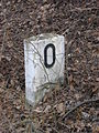
A zero stone marks the beginning of a railway line

Different kilometers, Karlsruhe Hbf track 6 and track 1

Overgrown hectometer stone with direction arrow for telephone (right)

Distance kilometer board on a (tunnel) wall with orange NBÜ marking; Addition "600" means exact positioning


Switzerland

In Switzerland, the railway lines are marked with kilometer and hectometer signs or stones. If the kilometers are marked on the catenary masts , meter symbols are used.

Odometer table: The number indicates the kilometer.

Hectometer table: The upper number indicates the kilometer, the lower one the hectometer.

Milepost between Solis and Solis Viaduct at the Albulalinie the Rhätischen web (RhB).

Meter table: The upper number indicates the kilometer, the lower one the meter.

Error profile panel between Solis and Solis Viaduct, including a meter panel.


Zero points

In the Olten train station there is a stone relief that documents the zero point of the distance measurement of the railway lines prescribed by the federal government. From the starting point in Olten, the Swiss Central Railway (SCB) measured the routes in one hour . However, the stone never marked zero kilometer. When the old linear measurements were replaced by the meter in 1877 , the SCB relocated the zero point of the kilometers to Basel .
The Swiss Federal Railways (SBB) have taken over the kilometers of their routes from their predecessors:
The zero point of the main network of the Rhaetian Railway (RhB) is in Landquart . The formerly independent Aroser and Berninabahn have their own kilometers.
Negative mileage
Since the extension of the Wipkinger line in 1894 with the construction of the Zurich train station viaduct , the route via Wipkingen to Oerlikon has started at the Zurich train station at kilometer –0.58.
Since 1997 Murilinie Bern – Worb has started in Bern Zytglogge at kilometer –0.48 instead of kilometer 0 in Bern Kirchenfeld . The Zytglogge – Kirchenfeld – Bern Egghölzli section is owned by the Bern Municipal Transport Authority (SVB), and the rest of the section is owned by the Bern – Solothurn regional traffic (RBS).
The Wädenswil – Einsiedeln line of the Swiss Southeastern Railway (SOB) begins at Wädenswil station at kilometer –0.10.
Austria

Track marking + kilometering of the New Lower Inn Valley Railway , Tyrol


An Austrian example of negative mileage was the start of the Austrian Southern Railway in the area of the former Vienna Southern Railway Station by relocating the station by around 200 meters.
Today, at Vienna Central Station, which replaces the Südbahnhof, an additional kilometer scale of 100 km downwards (99.9 ...) is used.
Web links
Individual evidence
- ↑ a b German Bahn AG (ed.): Directive network infrastructure engineering design (800), module kilometers, Hektometer- and additional characters attach (module 0104), effective from 1 September 2013 pp 5-7.
- ↑ Deutsche Bahn Netz AG (Ed.): Guideline Construction Technology, Leit-, Signal- u. Telecommunication technology (883), module track and construction surveying - kilometer railway lines (module 0010), valid from July 1st, 2008.
- ^ Rudolf W. Butz: Signals of the Swiss Railways . Orell Füssli Verlag, Zurich 1972, p. 99 .
- ↑ a b Federal Office of Transport: page no longer available , search in web archives: driving regulations . Bern, 2012 . R 300.2, section 2.6.5.
- ↑ a b c Hans G. Wägli: Swiss rail network and Swiss rail profile CH + . AS Verlag, Zurich 2010, ISBN 978-3-909111-74-9 (German, French).