Weser Valley
| coat of arms | Germany map | |
|---|---|---|

|
Coordinates: 51 ° 36 ' N , 9 ° 36' E |
|
| Basic data | ||
| State : | Hesse | |
| Administrative region : | kassel | |
| County : | kassel | |
| Height : | 110 m above sea level NHN | |
| Area : | 52.59 km 2 | |
| Residents: | 5144 (Dec. 31, 2019) | |
| Population density : | 98 inhabitants per km 2 | |
| Postal code : | 34399 | |
| Primaries : | 05571, 05572, 05574 | |
| License plate : | KS, HOG, WOH | |
| Community key : | 06 6 33 030 | |
| Address of the municipal administration: |
In the flap 1A 34399 Wesertal |
|
| Website : | ||
| Mayor : | Cornelius Turrey ( SPD ) | |
| Location of the community Wesertal in the district of Kassel | ||
Wesertal is a municipality in the Hessian district of Kassel , which was created on January 1, 2020 through the merger of the municipalities of Oberweser and Wahlsburg .
geography
Wesertal lies in the far north of Hesse on the eponymous Weser between the cities of Hann. Münden and Bad Karlshafen . The Solling rises to the north, the Bramwald to the southeast and the Reinhardswald to the left of the Weser . In the north of the municipality the Schwülme flows into the Weser.
The Wesertal community consists of the districts Arenborn , Gewissenruh , Gieselwerder , Gottstreu , Heisebeck , Lippoldsberg , Oedelsheim and Vernawahlshausen .
In the west Wesertal borders on the community-free area Gutsgebiet Reinhardswald , but not on any other Hessian community. The neighboring communities are all in Lower Saxony: in the north Bodenfelde and the community-free area Solling , in the northeast the city of Uslar (all district Northeim ), in the east the spots Adelebsen ( district Göttingen ) and the Uslar exclave Fürstenhagen and in the south Hann. Münden (district of Göttingen).
history
On October 28, 2018, parallel to the Hessian state election , there was a referendum on a community merger . 70.26% of the citizens of Oberweser and 74% of the citizens of Wahlsburg voted for a merger. This makes Wesertal the second newly formed municipality after Oberzent im Odenwald after the regional reform in Hesse in the 1970s.
The reason for the merger was the falling population (in Oberweser by 11%, in Wahlsburg by 15% within the last ten years), which means empty municipal coffers with high infrastructure costs. The municipalities had already merged finance departments, building yards and registry offices to reduce costs. The state of Hesse funded the initiation of the merger process with 530,000 euros, with further funds to follow.
Alternative names proposed for the new municipality included Oberweser-Wahlsburg, Wahlsweser, Oberweserburg and Oberwesertal.
badges and flags
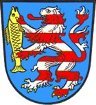
The coat of arms of the former municipality of Oberweser was adopted as the coat of arms of the Wesertal community. The description reads: "In blue a lion divided nine times by silver and red, holding a golden fish in its paws."
The municipality's flag is divided into red-white-red in a ratio of 1: 3: 1 and is covered with the municipality's coat of arms.
traffic
The Wesertal community is located on the B 80 .
The Vernawahlshausen district has a train stop on the Göttingen – Bodenfelde railway line .
Web links
proof
- ↑ Hessian State Statistical Office: Population status on December 31, 2019 (districts and urban districts as well as municipalities, population figures based on the 2011 census) ( help ).
- ↑ a b Fusion of Oberweser and Wahlsburg: citizens voted by name , on www.hna.de on March 20, 2019, accessed on August 3, 2019
- ↑ Oberweser and Wahlsburg: Citizens clearly vote for the merger on www.hna.de from October 28, 2018, accessed on August 3, 2019
- ↑ Citizens' decision on Sunday: Make 1 out of 2: Why Oberweser and Wahlsburg want to merge at www.hessenschau.de on October 27, 2018, accessed on August 3, 2018
- ↑ Hessen promotes measures to merge the municipalities of Oberweser and Wahlsburg on www.hessen.de from June 27, 2019, accessed on August 7, 2019
- ↑ Preliminary main statute of the Wesertal community from January 8, 2020 on wesertal.info, accessed on February 28, 2020


