
Liebenau (Hesse)
| coat of arms | Germany map | |
|---|---|---|
.png)
|
Coordinates: 51 ° 30 ' N , 9 ° 17' E |
|
| Basic data | ||
| State : | Hesse | |
| Administrative region : | kassel | |
| County : | kassel | |
| Height : | 144 m above sea level NHN | |
| Area : | 48.87 km 2 | |
| Residents: | 3005 (Dec. 31, 2019) | |
| Population density : | 61 inhabitants per km 2 | |
| Postal code : | 34396 | |
| Area code : | 05676 | |
| License plate : | KS, HOG, WOH | |
| Community key : | 06 6 33 016 | |
| LOCODE : | DE LIB | |
| City structure: | 8 districts | |
City administration address : |
Lacheweg 1 34396 Liebenau |
|
| Website : | ||
| Mayor : | Harald Munser ( FWG ) | |
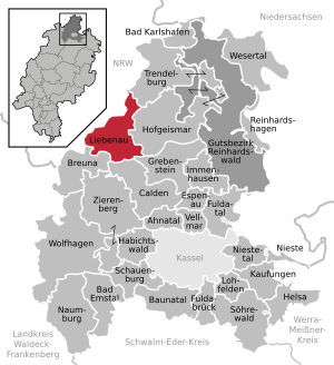
| Location of the city of Liebenau in the Kassel district | ||
  |
||


_De_Merian_Hassiae.jpg)
Liebenau ( Low German : Lebenogge ) is a small town in the northern Hessian district of Kassel .
geography
Geographical location
Liebenau is located on the northern border with North Rhine-Westphalia, almost in the far north of the Kassel district on the south-eastern edge of the Warburger Börde . It is located about 25 km (as the crow flies ) northwest of Kassel between Warburg in the west and Hofgeismar in the east.
Liebenau is traversed by the Diemel in a west-east direction , into which the Eggel flows above the village (coming from the north), the Vombach in Liebenau (also from the north) and below it the Warm (from the south).
A few kilometers away are the Solling northeast of Liebenau , the Reinhardswald to the east, the Habichtswald to the south and the Eggegebirge to the northwest , all of which are framed by nature parks with the exception of the Reinhardswald.
Neighboring communities
Liebenau borders the city of Trendelburg in the north, the city of Hofgeismar in the east, the city of Grebenstein in the southeast, the municipalities of Calden and Breuna (all in the Kassel district) in the south, and the cities of Warburg and Borgentreich in the west and northwest ( both in the Höxter district in North Rhine-Westphalia ).
City structure
In addition to the main town Liebenau (687 inhabitants), the city consists of the districts Ersen (357 inhabitants), Grimelsheim (60 inhabitants), Haueda (372 inhabitants), Lamerden (426 inhabitants), Niedermeiser (760 inhabitants), Ostheim (387 inhabitants) and Dwarfs (373 inhabitants).
history
The largest fossil site in North Hesse is in quarries near Lamerden and Haueda. Among other things, the remains of nothosaurs and fossil sea lilies were found here in the shell limestone . The owner of this site is the Kassel Natural History Museum, which regularly carries out excavations there.
The Warburger Börde with its rolling hills and fertile lowlands is an ancient settlement area. Numerous archaeological finds prove a continuous settlement since the Neolithic . Borderlands have also been here for a long time. In the past, Chatti , Cherusci and Saxons , later the bishops of Paderborn and the landgraves of Hessen fought for possession of the fertile landscape. The castle and town of Liebenau were first mentioned in 1293 when Hermann von Desenberg called Spiegel gave the castle and town of Liebenau to Count Otto von Waldeck as a fief . In 1465, Landgrave Ludwig II. Liebenau violently took possession of the Hesse-Paderborn feud (1464–1471) and destroyed the castle there . Since then, the place has been in Hesse.
Between 1945 and 1949 , Liebenau station became a border station between the British sector (North Rhine-Westphalia) and the US sector (Hesse).
Incorporations
On February 1, 1971, as part of the regional reform in Hesse, the previously independent communities of Grimelsheim, Haueda, Lamerden and Ostheim were incorporated into the city of Liebenau. On April 1, 1972, Ersen and Niedermeiser were added. Zwergen followed by state law on August 1, 1972.
politics
City Council
The local elections on March 6, 2016 produced the following results, compared to previous local elections:
| Parties and constituencies |
% 2016 |
Seats 2016 |
% 2011 |
Seats 2011 |
% 2006 |
Seats 2006 |
% 2001 |
Seats 2001 |
||
|---|---|---|---|---|---|---|---|---|---|---|
| FWG | Free voter community Liebenau | 62.4 | 14th | 58.1 | 13 | 57.8 | 13 | 50.7 | 12 | |
| SPD | Social Democratic Party of Germany | 30.7 | 7th | 34.1 | 8th | 34.3 | 8th | 42.2 | 10 | |
| CDU | Christian Democratic Union of Germany | 6.9 | 2 | 7.8 | 2 | 7.9 | 2 | 7.1 | 1 | |
| total | 100.0 | 23 | 100.0 | 23 | 100.0 | 23 | 100.0 | 23 | ||
| Voter turnout in% | 63.5 | 63.3 | 65.2 | 72.7 | ||||||
mayor
In November 2014, Harald Munser ( FWG ) was elected to succeed Peter Lange (FWG).
Partnerships
Liebenau has maintained a ring partnership with the towns of the same name since 1991
- Liebenau in Lower Saxony ,
- Liebenau in the Ore Mountains , district of Geising in Saxony and
- Liebenau in the Mühlviertel in Upper Austria .
traffic
The Liebenau station (Bz Kassel) on the Kassel – Warburg railway line, which was completed in 1848, has not been in operation since traffic ceased in 2015.
Personalities
- Gottfried Rabe von Pappenheim (1874–1955), district administrator of the Kassel district
- Werner Rabe von Pappenheim (1877–1915), German officer and diplomat
literature
- Maren Siegmann: Colorful splendor - the pearls of the early medieval grave fields of Liebenau, Nienburg / Weser and Dörverden districts, Verden / Aller. Chronology of the graves, development and way of wearing pearl jewelry, pearl technique. In: Contributions to the prehistory and early history of Central Europe. Volume 28; 5 volumes Beier & Beran, Weißbach / Langenweißbach 2002–2006
- Literature about Liebenau in the Hessian Bibliography
Web links
- Liebenau (municipality), district of Kassel. Historical local dictionary for Hessen. In: Landesgeschichtliches Informationssystem Hessen (LAGIS).
- Liebenau, District of Kassel. Historical local dictionary for Hessen. In: Landesgeschichtliches Informationssystem Hessen (LAGIS).
Individual evidence
- ↑ Hessian State Statistical Office: Population status on December 31, 2019 (districts and urban districts as well as municipalities, population figures based on the 2011 census) ( help ).
- ↑ Landgrave Regests online No. 354. Regest of the Landgraves of Hesse. In: Landesgeschichtliches Informationssystem Hessen (LAGIS).
- ^ Municipal reform: mergers and integration of municipalities from January 20, 1971 . In: The Hessian Minister of the Interior (ed.): State Gazette for the State of Hesse. 1971 No. 6 , p. 248 , item 328, para. 56 ( online at the information system of the Hessian state parliament [PDF; 6.2 MB ]).
- ↑ Law on the reorganization of the districts of Hofgeismar, Kassel and Wolfhagen (GVBl. II 330-17) of July 11, 1972 . In: The Hessian Minister of the Interior (ed.): Law and Ordinance Gazette for the State of Hesse . 1972 No. 17 , p. 225 , § 11 ( online at the information system of the Hessian state parliament [PDF; 1,2 MB ]).
- ^ Federal Statistical Office (ed.): Historical municipality directory for the Federal Republic of Germany. Name, border and key number changes in municipalities, counties and administrative districts from May 27, 1970 to December 31, 1982 . W. Kohlhammer GmbH, Stuttgart / Mainz 1983, ISBN 3-17-003263-1 , p. 398 .
- ^ Result of the municipal election on March 6, 2016. Hessian State Statistical Office, accessed in April 2016 .
- ^ Hessian State Statistical Office: Result of the municipal elections on March 27, 2011
- ^ Hessian State Statistical Office: Result of the municipal elections on March 26, 2006
- ↑ http://www.statistik-hessen.de/themenwahl/wahlen/daten/direktwahlen/liebenau-stadt/index.html

Ahnatal | Bad Emstal | Bad Karlshafen | Baunatal | Breuna | Calden | Espenau | Fuldabrück | Fulda Valley | Grebenstein | Habichtswald | Helsa | Hofgeismar | Immenhausen | Kaufungen | Liebenau | Lohfelden | Naumburg | Nieste | Niestetal | Reinhardshagen | Schauenburg | Söhrewald | Trendelburg | Vellmar | Wesertal | Wolfhagen | Zierenberg
Community-free area in the Kassel
district of Reinhardswald estate