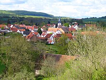
Niedermeiser
|
Niedermeiser
City of Liebenau
Coordinates: 51 ° 27 ′ 34 ″ N , 9 ° 18 ′ 26 ″ E
|
|
|---|---|
| Height : | 170 m above sea level NHN |
| Residents : | 786 |
| Incorporation : | April 1, 1972 |
| Postal code : | 34396 |
Niedermeiser is the most populous district of the small town of Liebenau in northern Hesse in the Kassel district .
Geographical location
Niedermeiser is the southernmost district of Liebenau in the West Hessian Depression near the border to the north and west of the Oberwälder Land and to the somewhat south-west of the Habichtswälder Bergland . It is located a little north of the Habichtswald Nature Park at the mouth of the Ruhrbach in the Warme . The core city of Liebenau is 4.4 km north-northwest, that of Warburg 11.5 km west-northwest, the core city of Hofgeismar 6.4 km northeast. The Rosenberg ( 299.7 m ) rises northeast of the village and the Fössenberg ( 205.9 m ) to the northeast .
history
More than 4000 years old graves and archaeological finds indicate a settlement of the area since at least the end of the Neolithic period at the transition to the Bronze Age .
The place Niedermeiser was first mentioned in a document in 1074. During the time of the Kingdom of Westphalia (1807-1813) the place was the administrative seat of the canton Niedermeiser .
Since April 1, 1972, Niedermeiser has been a district of Liebenau.
Infrastructure
Three federal highways run a few kilometers from the town ; The B 7 is 2 km south , the B 83 is 6 km east-northeast and the B 241 is just under 12 km north-west . The next motorway junctions are at Warburg and Breuna on the A 44 . There are IC and ICE train stations in Warburg and Kassel ; There are regional train stations in Hofgeismar and Grebenstein . The nearest regional airports are Kassel Airport in Calden and Paderborn / Lippstadt Airport .
Economy and tourism
Niedermeiser has no industry, only agricultural and handicraft businesses. There are several accommodation options in the village in a guesthouse and several apartments.
Culture and sights
In the vicinity there are numerous sights such as the historic townscapes of Warburg, Hofgeismar and Bad Karlshafen , the city of Kassel or the castles in the neighboring Reinhardswald such as B. the Saba , the Trendel or the Krukenburg .
A "pleban", that is, a local priest, is documented for the first time in 1464, which speaks in favor of a local church at this time, whose patronage was that of the von Malsburg. The date 1593 on a corner stone of the tower refers to an older church, probably already renovated at that time. The Protestant church is dated to the year 1774 above the eastern south portal and adorned with the initials of Landgrave Friedrich II of Hesse-Kassel, who ruled from 1760 to 1785, in addition to a four-line inscription. The Protestant church consists of the late Gothic west tower with spire from 1876 and the hall building with hipped roof from 1774. The construction equipment was largely preserved until after World War II, but was completely changed in a renovation before 1970.
In addition to the Christian lying cemetery Jewish cemetery was laid out. 1854 Up to 1929, the year of the last burial , at least 19 burials had taken place. Of the original grave stones for Jews from Liebenau-Niedermeiser and the surrounding area, who died between 1854 and 1929, only one remains. The cemetery is a protected cultural monument .
Individual evidence
- ^ Federal Statistical Office (ed.): Historical municipality directory for the Federal Republic of Germany. Name, border and key number changes in municipalities, counties and administrative districts from May 27, 1970 to December 31, 1982 . W. Kohlhammer GmbH, Stuttgart and Mainz 1983, ISBN 3-17-003263-1 , p. 398 .
Web links
- Niedermeiser , on Stadt-liebenau.de
- Niedermeiser, district of Kassel. Historical local dictionary for Hessen. In: Landesgeschichtliches Informationssystem Hessen (LAGIS).


