
Höxter district
| coat of arms | Germany map |
|---|---|

|

Coordinates: 51 ° 41 ′ N , 9 ° 11 ′ E |
| Basic data | |
| Existing period: | 1975– |
| State : | North Rhine-Westphalia |
| Administrative region : | Detmold |
| Regional association : | Westphalia-Lippe |
| Administrative headquarters : | Höxter |
| Area : | 1,201.42 km 2 |
| Residents: | 140,251 (Dec. 31, 2019) |
| Population density : | 117 inhabitants per km 2 |
| License plate : | HX, WAR |
| Circle key : | 05 7 62 |
| NUTS : | DEA44 |
| Circle structure: | 10 municipalities |
| Address of the district administration: |
Moltkestrasse 12 37671 Höxter |
| Website : | |
| District Administrator : | Friedhelm Spieker ( CDU ) |
| Location of the district of Höxter in North Rhine-Westphalia | |
  |
|
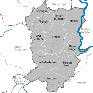
The district of Höxter is a district in the administrative district of Detmold ( Ostwestfalen-Lippe ) in the far east of North Rhine-Westphalia and lies with its borders on the triangle of Lower Saxony and Hesse.
County town is Höxter . With 118 inhabitants per km², the district has the lowest population density of all districts in North Rhine-Westphalia and, after Olpe, the second lowest population of all districts in North Rhine-Westphalia.
geography
Neighboring areas
The district of Höxter borders in a clockwise direction in the northeast on the districts of Holzminden and Northeim (both in Lower Saxony ), on the districts of Kassel and Waldeck-Frankenberg (both in Hesse ) and on the districts of Hochsauerlandkreis , Paderborn and Lippe (all in North Rhine-Westphalia) .
Population and district structure
The Höxter district is divided into ten municipalities, all of which are towns . The district town of Höxter is considered a middle district town . The following table shows the municipalities of the district in alphabetical order with the number of inhabitants on December 31, 2019, the area and the population density:
|
  |
According to a population forecast by the Bertelsmann Foundation from 2011, the Höxter district will have the oldest population of all municipalities in North Rhine-Westphalia in 2030. Around 50 percent of the population will then be older than 52 years.
The IT.NRW says in its forecast of 2015 a further decline in population by 9,700 residents by 2025 ahead.
With regard to the labor force, the IT.NRW forecasts a decline of 25.9 percent from 69,913 (2014) to only 51,800 (2040) in its study from 3/2016. This decline by a total of 18,113 economically active persons is divided among men by −9,622 (from 40,622 to 31,000) and among women by −8,491 (from 29,291 to 20,800). This above-average loss is, in addition to the generally forecast population decline, and a. due to demographic change ( old age quota ).
history
The district was created as part of the North Rhine-Westphalian regional reform ( Sauerland / Paderborn law ) on January 1, 1975 by amalgamating the previous Höxter district with the former Warburg district . It largely coincides with the Oberwald district of the historic Hochstift Paderborn and the former Hochstift Corvey .
In the joint area change agreement of the districts of Warburg and Höxter of July 24, 1974 on the reorganization of the district, it was agreed in § 1 to name the joint new district as the Brakel district with its seat in Brakel. This contract was accepted by the Höxter district council at the meeting on July 23, 1974 with regard to § 1 with 24 votes in favor, against 18 against with one abstention and with §§ 2-19 with two votes against and one abstention. Despite the consent of the Warburg district council to this area change agreement, the state parliament's decision on the Sauerland / Paderborn law there voted with a narrow majority in favor of the district name Kreis Höxter and the seat in Höxter and thus decided against the previously agreed area change agreement. Even naming the new district as the Höxter-Warburg district , comparable to the naming of the Minden-Lübbecke district newly formed a year earlier , was not approved by the Düsseldorf state parliament.
Population development
|
|
politics
District council
Currently there is the following distribution of seats according to parliamentary groups in the district council (as of September 2014):
| CDU | SPD | GREEN | Citizen List | FDP | Non-attached | total |
|---|---|---|---|---|---|---|
| 22nd | 10 | 4th | 3 | 2 | 1 | 42 |
| DIE LINKE 1 |
District Administrator
In the 2009 local elections, District Administrator Friedhelm Spieker was elected by the Christian Democratic Union of Germany with 59.2 percent of the vote. He took over the office from Hubertus Backhaus on October 20, 2009. Klaus Schumacher has been the district director since 2013.
- Former district administrators
- 1973–1989 Alex Brunnberg (CDU)
- 1989–1994 Karl Schneider (CDU)
- 1994–1996 Franz-Josef Thöne (CDU)
- 1996-2009 Hubertus Backhaus (CDU)
- Since 2009 Friedhelm Spieker (CDU)
- Former senior district directors
- 1968–1996 Paul Sellmann (CDU)
coat of arms

Like many newly formed districts, the Höxter district also has an old and a new coat of arms, with which the old Warburg district is to be paid tribute. The blazon of today's coat of arms reads: “In silver (white) a blue lily; above it in a golden (yellow) shield head, bounded by a blue wavy bar, a red continuous cross. "
traffic
Street
The district of Höxter is accessed by the federal highways B 7 , B 64 , B 68 , B 83 , B 239 , B 241 and B 252 and in the extreme south by the federal motorway A 44 .
Rail transport
In 1851, the state-owned Royal Westphalian Railway Company connected the current Hamm – Warburg line via Altenbeken to the Kassel – Warburg line near Warburg . Here in 1864/65 the Eggebahn branched off to Höxter, which was connected to the Braunschweig Railway near Holzminden . The Solling Railway to Göttingen and Northeim began in Ottbergen in 1878 .
The Hanover-Altenbeken Railway has been running through the western edge of the district since 1872 . In the south, the network of the Bergisch-Märkische Eisenbahn-Gesellschaft expanded : the Upper Ruhr Valley Railway opened in 1873 from Warburg in the direction of Brilon Wald – Hagen and in 1876 a cross-connection from Holzminden via Wehrden flowed into Scherfede .
The Prussian state railway remained there then left to take two supplements in operation:
- 1890 from Warburg to Volkmarsen as a section, so-called "Twist Valley Railway " of the Warburg – Sarnau railway in the province of Hesse-Nassau and
- 1895 from Himmighausen near Altenbeken to Detmold in the Principality of Lippe.

Of 172 km of routes, 54 km of passenger traffic were closed and later dismantled:
- 1967: Warburg – Wormeln – Welda – Volkmarsen, (12 km long “Twist Valley Railway”) for passenger trains and from 1977 for freight traffic, as well
- 1984: Holzminden – Lüchtringen-Steinkrug – Fürstenberg – Wehrden – Beverungen – Dalhausen – Scherfede (42 km)
ICE trains and ICs on the Kassel-Wilhelmshöhe - Dortmund connection stop in Warburg . The train stations or stops in Bad Driburg, Brakel, Höxter, Lauenförde-Beverungen, Ottbergen, Wehrden are in operation for passenger transport, and the NordWestBahn trains run every hour on weekdays from Paderborn to Northeim or Göttingen as well as Warburg and Willebadessen and the Eurobahn every hour between Münster via Hamm , Paderborn and Warburg. There are also Warburg and Scherferde with hourly regional express trains between Hagen and Warburg and Steinheim with hourly trains of the Hanover S-Bahn between Hanover and Paderborn.
Airports and airfields
The airport Hoexter-Holzminden is the only commercial airport in the district Hoexter. The nearest airports are the Airport Paderborn / Lippstadt , the Kassel-Calden Airport and the airport Hannover-Langenhagen .
Attractions
Museums
There are 20 museums in the Höxter district (see list of museums in the Höxter district ):
- in Bad Driburg: Dringenberg Castle Local History Museum , Friedrich Wilhelm Weber Museum , Glass Museum , Heerse Castle
- in Beverungen: Korbmacher-Museum
- in Borgentreich: village museum , organ museum
- in Brakel: Village Museum and Urdorf Museum , FSB Franz Schneider Exhibition , Rheder Hussar Museum , City Museum
- in Höxter: From the villa to the city - exhibition on city history (housed in Corvey Castle), Forum Jacob Pins (museum in the Adelshof Heisterman von Ziehlberg)
- in Nieheim: Heimat- und Sackmuseum , Westfalen Culinarium (German Cheese Museum, Westphalian Bread Museum, Westphalian Ham Museum, Westphalian Beer Museum)
- Steinheim: Fire Museum , Heritage Museum Ottenhausen , Furniture Collection
- in Warburg: Museum im Stern
- in Willebadessen: Foundation European Sculpture Park eV (exhibition in the park of the former Benedictine convent)
Architectural monuments
Jewish cemeteries
There are 15 Jewish cemeteries in the Höxter district that still have tombstones :
- Jewish cemetery (Amelunxen)
- Jewish cemetery (Bad Driburg)
- Jewish cemetery (Beverungen)
- Jewish cemetery (Brakel)
- Jewish cemetery (Bruchhausen)
- Jewish cemetery (Dringenberg)
- Jewish cemetery (Fürstenau)
- Jewish cemetery (Höxter)
- Jewish cemetery (Nieheim)
- Jewish cemetery (Ovenhausen)
- Jewish cemetery (Peckelsheim)
- Jewish cemetery (Rimbeck)
- Jewish cemetery (steels)
- Jewish cemetery (Steinheim)
- Jewish cemetery (Warburg)
(see category: Judaism in the Höxter district ). They are cultural monuments - stone witnesses to formerly existing Jewish communities and an often lively Jewish community life up to the 1930s.
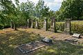
Dringenberg Jewish cemetery

Höxter Jewish cemetery
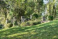
Rimbeck Jewish cemetery

Steinheim Jewish cemetery

Jewish cemetery Hanseatic City of Warburg
.jpg)

.jpg)
.jpg)

Healthcare
| hospital | Seat | beds |
|---|---|---|
| St. Ansgar Hospital (location of the Weser-Egge Clinic, which is part of the Catholic Hospital Association Weser-Egge ) |
Höxter | 396 |
| St. Vincenz Hospital (location of the Weser-Egge Clinic, which is part of the Catholic Hospital Association Weser-Egge ) |
Brakel | 100 |
| St. Josef Hospital (location of the Weser-Egge Clinic, which is part of the Catholic Hospital Association Weser-Egge ) |
Bad Driburg | 263 |
| St. Rochus Hospital (location of the Weser-Egge Clinic, which is part of the Catholic Hospital Association Weser-Egge ) |
Steinheim | 100 |
|
St. Petri-Hospital Warburg , has been part of the Helios Kliniken Group since 2014 and previously to the Warburg Hospital Association |
Warburg | 153 |
| total | 1012 |
The St. Petri-Hospital Warburg will move into a new clinic on Hüffertstrasse in autumn 2013. Around 33 million euros will be invested in the first construction phase.
Participations of the district of Höxter
- 73.91% savings bank association Höxter
- 60.00% Hospital Purpose Association Warburg, see also St. Petri Hospital Warburg , which was sold to the Rhön Clinic in May 2008
- 51.00% Abfallwirtschaftsgesellschaft Höxter mbH (AWG), u. a. also operator of the Wehrden landfill in Beverungen-Wehrden, 49.0% owned by E.ON Westfalen Weser
- 44.56% Society for Economic Development in District Höxter mbH (GfW)
- 36.84% Nahverkehrsverbund Paderborn-Höxter (NPH) (Zweckverband), umbrella association is the Zweckverband Nahverkehr Westfalen-Lippe (NWL)
- 33.33% Kulturkreis Höxter-Corvey GmbH, sponsor of the "Corveyer Musikwochen" and other musical events, as well as the "Museum Höxter-Corvey"
- 29.27% Diemelwasserverband Warburg, founded in 1951
- 22.73% Teutoburg Forest / Eggegebirge Nature Park Association
- 14.29% Study Institute for Local Administration Hellweg-Sauerland (Zweckverband) based in Soest
- 12.50% Radio Paderborn Betriebsgesellschaft mbH & Co. KG, see Radio Hochstift
- 7.14% OstWestfalenLippe Marketing GmbH
- 7.14% routes through the country gGmbH based in Detmold , sponsor of the literature and music festival in Ostwestfalen-Lippe
- 7.14% Chemical and Veterinary Investigation Office Ostwestfalen-Lippe (CVUA-OWL)
- 3.92% Paderborn / Lippstadt Airport
- 1.37% E.ON Westfalen Weser based in Paderborn
- 1.00% Municipal Shareholders' Association RWE Westfalen Weser Ems GmbH (KAV)
- 0.40% E.ON Mitte based in Kassel
- 0.21% Interargem GmbH based in Bielefeld , founded in 1996 and a subsidiary of E.ON Energy from Waste AG (EEW)
License Plate
On July 1, 1956, the district of Höxter was assigned the distinctive sign HX when the license plates that are still valid today were introduced . It is still issued today.
Until the 1990s, vehicles from the old district of Warburg received license plates with the letter pairs HX-WA to ZZ, then also HX-VA to VZ and the numbers from 1 to 99, then with the letter pairs HX-AA to AZ and HX-WA to WD and the numbers from 100 to 999.
In the meetings of February 9, 2012 and April 23, 2015, the Höxter district council initially decided by a majority not to make use of the option of reintroducing the old WAR label (in addition to the existing HX ).
However, at the district council meeting on October 1, 2019, this step was decided with 28 yes and 3 no votes (with 5 abstentions). After the approval of the Federal Ministry of Transport, the license plate was first issued on November 8, 2019 at the registration office in Warburg.
literature
- Alois Mayr, Adolf Schüttler, Klaus Temlitz: The Höxter district. Cities and municipalities in Westphalia, Vol. 3. Geographical Commission for Westphalia / LWL. Ardey-Verlag , Münster, 1996. ISBN 3-87023-077-0 .
- Anna Bálint: Höxter in bronze and stone. Forgotten monuments and modern art in public spaces. Verlag Jörg Mitzkat, Holzminden 1999, ISBN 3-931656-23-3 .
- Anna Bálint: Castles, palaces and historical aristocratic residences in the Höxter district. District Höxter (ed.), Höxter 2002, ISBN 3-00-009356-7 .
- Burkhard Beinlich, Frank Grawe: Hidden treasures between Egge and Weser. The diversity of nature in the Höxter district. Landscape station in the Höxter district (ed.), Verlag Jörg Mitzkat, Holzminden, 2008. ISBN 978-3-940751-07-2 .
Web links
- Website of the district of Höxter
- Link catalog on the topic of Höxter district at curlie.org (formerly DMOZ )
- Description of the district of Höxter in the series Cities and Municipalities in Westphalia
- Höxter district in the Westphalia Culture Atlas
References and comments
- ↑ Population of the municipalities of North Rhine-Westphalia on December 31, 2019 - update of the population based on the census of May 9, 2011. State Office for Information and Technology North Rhine-Westphalia (IT.NRW), accessed on June 17, 2020 . ( Help on this )
- ↑ Population of the municipalities of North Rhine-Westphalia on December 31, 2019 - update of the population based on the census of May 9, 2011. State Office for Information and Technology North Rhine-Westphalia (IT.NRW), accessed on June 17, 2020 . ( Help on this )
- ↑ Federal and State Statistical Offices: Online research of the municipal directory ( memento of the original from October 9, 2014 in the Internet Archive ) Info: The archive link was inserted automatically and has not yet been checked. Please check the original and archive link according to the instructions and then remove this notice.
- ↑ nw-news.de
- ^ Federal Statistical Office (ed.): Historical municipality directory for the Federal Republic of Germany. Name, border and key number changes in municipalities, counties and administrative districts from May 27, 1970 to December 31, 1982 . W. Kohlhammer, Stuttgart / Mainz 1983, ISBN 3-17-003263-1 , p. 323 f .
- ↑ Area change agreement, passed by the Höxter district council on July 24, 1974
- ^ State database North Rhine-Westphalia
- ↑ election results.nrw.de
- ↑ Information page on the district coat of arms on the district's website ( Memento from May 14, 2011 in the Internet Archive )
- ↑ Information from bahn.de, for the 2016 timetable
- ↑ Press release ( memento of January 18, 2016 in the Internet Archive ) on the 2015 district council decision , accessed on November 18, 2015
- ↑ Press office of the district of Höxter: District council decides to reintroduce the license plate for Warburg. Retrieved November 15, 2019 .

Independent cities: Aachen | Bielefeld | Bochum | Bonn | Bottrop | Dortmund | Duisburg | Düsseldorf | Food | Gelsenkirchen | Hagen | Hamm | Herne | Cologne | Krefeld | Leverkusen | Mönchengladbach | Mülheim an der Ruhr | Munster | Oberhausen | Remscheid | Solingen | Wuppertal
Districts and city regions: City region Aachen | Borken district | Coesfeld district | District of Düren | Ennepe-Ruhr district | District of Euskirchen | District of Gütersloh | District of Heinsberg | Herford district | Hochsauerlandkreis | District of Höxter | District of Kleve | Circle lip | Märkischer Kreis | District of Mettmann | District of Minden-Lübbecke | Oberbergischer Kreis | District of Olpe | Paderborn district | Recklinghausen district | Rhein-Erft district | Rheinisch-Bergischer Kreis | Rhein-Kreis Neuss | Rhein-Sieg-Kreis | District of Siegen-Wittgenstein | District of Soest | District of Steinfurt | District of Unna | District of Viersen | District of Warendorf | Wesel district