District of Höxter (1816–1974)
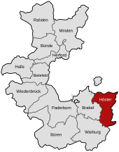
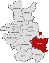
| coat of arms | Germany map |
|---|---|

|

Coordinates: 51 ° 46 ' N , 9 ° 22' E |
| Basic data (as of 1974) | |
| Existing period: | 1816-1974 |
| State : | North Rhine-Westphalia |
| Administrative region : | Detmold |
| Regional association : | Westphalia-Lippe |
| Administrative headquarters : | Höxter |
| Area : | 685.64 km 2 |
| Residents: | 99,300 (Dec. 31, 1973) |
| Population density : | 145 inhabitants per km 2 |
| License plate : | HX |
| Circle key : | 05 7 36 |
| Circle structure: | 7 municipalities |
| Location of the district of Höxter in North Rhine-Westphalia | |
The county Hoexter (1939-1969 district Hoexter ) was from 1816 to 1974 existing circle . The district was initially part of the administrative district of Minden in the Prussian province of Westphalia , from 1946/47 part of the North Rhine-Westphalian administrative district of Detmold . The administrative seat was Höxter . The district went up in 1975 as part of the North Rhine-Westphalian regional reform together with the Warburg district in the newly founded Höxter district .
geography
Geographical location
The district area was in the Upper Weserbergland . The valley of the Weser in the east bounded it against the Weser-Leine-Bergland , the Egge Mountains in the west against the Westphalian Bay . In front of the harrow in the east is the harrow foreland. The largest sub-landscape in the district was the Brakeler Bergland with the Nethubgland in the center and the Beverbergland in the southeast of the district. The Brakeler Bergland encircle the Steinheimer Börde, the Löwendorfer Hügelland, the Köterbergland and the Fürstenau Bergland in a clockwise direction in the north. The Höxter-Holzmindener Wesertal and the Beverunger Wesertal form the end to the east.
Since the main ridge of the Egge Mountains forms the Rhine-Weser watershed , the entire district area belonged to the catchment area of the Weser , which was the most important river in the district. The other rivers included the Nethe (with its tributaries Aa and Brucht) and the Emmer .
Neighboring areas
In 1972 the district of Höxter bordered clockwise in the north, beginning with the district of Detmold (in North Rhine-Westphalia), the districts of Holzminden and Northeim (in Lower Saxony ), the district of Hofgeismar (in Hesse ) and the districts of Warburg and Paderborn (both in turn In North Rhine-Westphalia).
The Lügde office was a northern exclave of the district until 1969 . It recently bordered the Lower Saxony district of Hameln-Pyrmont in the north and east and the Detmold district in the south and west.
history


The area of the district encompassed the northern part of the Upper Forest district of the Hochstift Paderborn and the area of Corvey , a former Benedictine abbey that had just been raised to a diocese in 1792.
In 1802 Prussia occupied the Paderborn Monastery and, after the Reichsdeputationshauptschluss 1803, formed the Principality of Paderborn from it . The Principality of Corvey was also secularized in 1803 and fell to Nassau-Dillenburg as the Principality of Corvey . From 1807 to 1813 the areas mentioned belonged to the Kingdom of Westphalia , which introduced an administrative structure based on the French model. The later district area now belonged to the Höxter district in the Fulda department and was divided into the cantons of Albaxen, Beverungen, Höxter and Vörden. After the French era , the Principality of Paderborn fell back to Prussia, to which the Principality of Corvey was also awarded. Both territories became part of the administrative district of Minden in the newly formed province of Westphalia .
On October 18, 1816, by decree of the royal government in Minden , the district of Höxter was formed from the cantons of Albaxen, Beverungen, Höxter and Vörden, which were established during the French era . On January 1, 1832, the neighboring Brakel district was dissolved and incorporated into the Höxter district. The thus enlarged circle was divided into the nine administrative districts Albaxen, Brakel, Beverungen, Driburg, Höxter, Lügde, Nieheim, Steinheim and Vörden, also known as mayor's offices. These administrative units corresponded to the cantons of the same name , which had existed in the Kingdom of Westphalia from 1807 to 1813.
As part of the introduction of the rural community order for the province of Westphalia , the nine offices of Albaxen , Beverungen , Brakel , Driburg , Harzberg , Höxter , Nieheim , Steinheim and Vörden were established in 1843 and 1844 . The seven cities of Beverungen , Brakel , Driburg , Höxter , Lügde , Nieheim and Steinheim remained vacant.
The offices of Höxter and Albaxen had a common bailiff from the beginning and since 1852 they formed the combined office of Höxter-Albaxen . The offices of Nieheim and Steinheim have also been administered in personal union since their establishment in 1843 and formed the combined office of Nieheim-Steinheim since 1852 . The Harzberg Office, later also called Lügde-Harzberg Office or Lügde Office , consisted only of the Harzberg community and was co-administered by the City of Lügde.
In 1864 the Abbenburg-Bökerhof estate was separated from the Bökendorf community . In 1920 the Office Höxter-Albaxen was renamed Amt Höxter-Land . The Abbenburg-Bökerhof estate was incorporated back into Bökendorf in 1928. In 1934 the Harzberg office was dissolved, making Harzberg a municipality that was free of office. In 1936 the office of Nieheim-Steinheim was separated into the two offices of Nieheim and Steinheim. At the same time, the cities of Steinheim and Nieheim were incorporated into the respective offices. In the same year, the municipality of Hagedorn moved from the Vörden office to the Steinheim office. In 1937 Beverungen was incorporated into the Beverungen Office and in 1938 Brakel into the Brakel Office.
The previously free city of Lügde and the Harzberg municipality formed the Lügde office since 1951 . In 1964, the new community Vordereichholz was founded from parts of Bergheim , Steinheim and Vinsebeck in the Steinheim district . In 1969, the district of Höxter consisted of two cities with no offices and eight offices with a total of seven cities and 68 communities.
On October 1, 1969, the district became the district of Höxter.
The law on the reorganization of the Höxter district of December 2, 1969 resulted in a municipal reform on January 1, 1970 . All offices were dissolved. The municipalities of the Steinheim district up to Kempenfeldrom formed the new town of Steinheim with Grevenhagen (until then an exclave of the Detmold district ). The municipalities of the Brakel district were merged to form the new town of Brakel, the communities of the Nieheim district to form the new town of Nieheim and the communities of the Vörden district to form the new town of Marienmünster . The city of Bad Driburg was merged with the municipalities of the Driburg district to form the new city of Bad Driburg. The municipalities of the Beverungen office formed the new city of Beverungen, but without Bruchhausen , which was merged with the city of Höxter and the municipalities of the Höxter-Land office to form the new city of Höxter.
The law for the reorganization of the Detmold district , which came into force at the same time , meant that Kempenfeldrom became part of the town of Horn-Bad Meinberg in the Detmold district; in addition, Lügde and Harzberg were merged with several municipalities in Lippe to form the new city of Lügde in the Detmold district.
On January 1, 1975 the Sauerland / Paderborn law came into force, which merged the Höxter district with the Warburg district to form the new Höxter district. From the previous office of Dringenberg-Gehrden of the Warburg district, Neuenheerse , Kühlsen and the city of Dringenberg were incorporated into the city of Bad Driburg and Auenhausen , Frohnhausen , Hampenhausen , Siddessen and the city of Gehrden were incorporated into the city of Brakel .
Population development
The following overview shows the population of the Höxter district according to the respective territorial status. Changes in the territorial status resulted primarily from the amalgamation of the districts of Höxter and Brakel on January 1, 1832, the transfer of an approximately 0.2 km² inhabited area of the municipality of Lügde to the municipality of Pyrmont on April 1, 1922 and the municipality reform in the districts of Höxter and Detmold on January 1, 1970, when Grevenhagen was incorporated into the district and Lügde, Harzberg and Kempenfeldrom were transferred to the district of Detmold.
The figures are census results or an extrapolation for 1968 and 1973. Until 1864, the information relates to the “customs clearance population”, from 1867 to the “local population” and from 1925 to the resident population .
|
|||||||||||||||||||||||||||
|
|
|
||||||||||||||||||||||||||||||||||||||||||||||||||||||||||||||||||||
From 1939 to 1950 the population increased by over 40%, mainly due to the admission of displaced persons, refugees and evacuees. By 1961, as a result of the normalization of the situation, there was a slight decrease of 4%, followed by a strong increase of 8.5% by 1968, which exceeded the 100,000 mark. The population for 1970 has already been influenced by the reform of the municipality in the districts of Höxter and Detmold: The communities of Harzberg, Kempenfeldrom and Lügde had been transferred to the district of Detmold on January 1, 1970, in return the municipality of Grevenhagen was incorporated into the district of Höxter been.
politics
Results of the district elections from 1946 to 1970
The list only shows parties and constituencies that received at least two percent of the votes in the respective election.
Share of votes of the parties in percent
| year | CDU | SPD | DZP | FDP | BHE |
|---|---|---|---|---|---|
| 1946 1 | 58.8 | 17.5 | 19.8 | ||
| 1948 | 41.9 | 24.6 | 24.4 | 7.2 | |
| 1952 | 40.6 | 20.1 | 18.5 | 9.5 | 9.8 |
| 1956 | 47.2 | 23.0 | 15.0 | 10.2 | 4.6 |
| 1961 | 52.4 | 19.8 | 13.8 | 7.5 | 5.9 |
| 1964 | 54.8 | 24.9 | 11.6 | 8.7 | |
| 1970 | 58.2 | 25.9 | 10.8 | 5.1 |
footnote
1 1946: additionally: KPD: 3.6%
District administrators
- 1817–1845 Philipp von Wolff called Metternich
- 1845–1887 Friedrich von Wolff called Metternich
- 1887–1917 Karl Körfer
- 1917–1918 Karl von Wolff called Metternich
- 1918–1933 RR Clemens von Droste zu Hülshoff
- 1933 First District Deputy Hans Ummen (substitute)
- 1933–1939 Government Assessor Hans Reschke from Wandsbek
- 1939–1943 Senior Councilor Friedrich Hueter
- 1943–1945 ORR Karl Wolff from Detmold (provisional)
- 1946–1949 Heinrich Schlüter (1883–1971) from Godelheim
- 1949–1956 Hermann Thiele (1895–1959) from Beverungen
- 1956–1958 Franz Lüke (1906–1966) from Höxter
- 1958–1973 Wilhelm Weskamp (1903–1986) from Bad Driburg
- 1973–1989 Alex Brunnberg (1915–1989) from Brakel
Oberkreisdirektor
Former Upper District Directors of the Höxter District:
- 1946 Wilhelm Kronsbein (former mayor of the city of Höxter, for a short time district administrator of the district of Höxter and from 1951 senior councilor in Cologne)
- 1950–1968 Eduard Buss
- 1968–1997 Paul Sellmann (CDU)
coat of arms
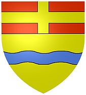
Description : Under the red head of the shield with a continuous gold (yellow) cross in gold (yellow) a blue wave bar.
The head of the shield symbolizes affiliation to the former Paderborn monastery, the wavy bar the Weser.
The coat of arms was approved on January 17, 1953.
After the districts of Höxter and Warburg were merged on January 1, 1975 to form the new district of Höxter, on February 12, 1976, the latter received a new coat of arms.
Cities and municipalities in the Höxter district
Administrative structure until 1969
Up to December 31, 1969 there were two cities and eight offices in the Höxter district . Of the 75 municipalities belonging to the office, seven had city rights.
According to offices (area and resident population as of June 6, 1961, district seat *):
- Official:
- Bad Driburg , city: 26.82 km², 7,898 E
- Höxter *, city: 23.64 km², 15,156 E
- Office Beverungen (administrative seat: Beverungen): 108.51 km², 14,115 E
- Amelunxes
- Beverungen , city
- Blankenau
- Bruchhausen
- Dalhausen
- Drenke
- Haarbrück
- Manufacture
- Jakobsberg
- Rothe
- Tietelsen
- Wehrden
- Würgassen
- Amt Brakel (administrative seat: Brakel): 137.74 km², 11,946 E
- Office Driburg (administrative seat: Bad Driburg ¹): 45.77 km², 3,012 E
- Office Höxter-Land (administrative seat: Höxter ¹): 123.06 km², 14,714 E
- Albaxen
- Bödexen
- Bosseborn
- Brenkhausen
- Fürstenau
- Godelheim
- Lüchtringen
- Lütmarsen
- Ottbergen
- Ovenhausen
- Steels
- Office Lügde (administrative seat: Lügde): 32.25 km², 4,831 E
- Amt Nieheim (administrative headquarters: Nieheim): 79.86 km², 5,726 E
- Entrup
- Heating
- Eversen
- Himmighausen
- Holzhausen
- Merlsheim
- Nieheim , city
- Oeynhausen
- Schönenberg
- Sommersell
- Office Steinheim (administrative seat: Steinheim): 76.25 km², 10.904 E
- Bergheim
- Hawthorn
- Kempenfeldrom
- Ottenhausen
- Rolfzen
- Sandebeck
- Steinheim , city
- Vinsebeck
- Pre-oak (newly formed in 1964)
- Amt Vörden (administrative seat: Vörden): 64.18 km², 4,503 E.
- Altenbergen
- Born
- Bredenborn , city
- Bremerberg
- Express verse
- Großerbreden
- High house
- Littles
- Kollerbeck
- Löwendorf
- Munsterbrock
- Papenhöfen
- Vörden , city
¹ Administrative seat, but not official
Administrative division 1970 to 1974
When the reorganization came into force, the Höxter district consisted of eight towns from January 1, 1970 to December 31, 1972 and seven towns until December 31, 1974:
| Surname | Area in km² | Residents |
|---|---|---|
| Bad Driburg , city | 72.59 | 12,950 |
| Beverungen , city | 97.60 | 14,894 |
| Brakel , city | 137.73 | 12,779 |
| Höxter *, city | 157.70 | 32,630 |
| Marienmünster , city | 64.23 | 4,720 |
| Nieheim , city | 79.80 | 6.374 |
| Steinheim , city | 75.66 | 11,834 |
(Area and resident population as of May 27, 1970, district seat *)
The city of Lügde moved to the Lippe district on January 1, 1973 .
License Plate
On July 1, 1956, the district was assigned the distinctive sign HX when the license plates that were still valid today were introduced .
See also
Web links
- Law on the reorganization of the Höxter district of December 2, 1969
- Sauerland / Paderborn law of November 5, 1974
Individual evidence
- ^ Regional Association Westphalia-Lippe (ed.); Project Westphalian History: "Royal Decree, whereby the division of the kingdom into eight departments is ordered", page 101
- ^ Westphalia Lexicon 1832-1835 . In: Landschaftsverband Westfalen-Lippe (Ed.): Reprints for the Westphalian archive maintenance . tape 3 . Münster 1978, p. 158 (reprint of the original from 1834).
- ↑ Landgemeinde -ordnung for the Province of Westphalia from October 31, 1841 (PDF; 1.6 MB)
- ^ Official Journal of the Minden Government 1843. Accessed February 2, 2014 .
- ^ Official Journal of the Minden Government 1844. Retrieved February 2, 2014 .
- ^ Official Journal of the Minden Government 1843: Formation of the offices of Höxter and Albaxen
- ^ A b c d e f g Wolfgang Leesch: Administration in Westphalia 1815-1945 . In: Publications of the Historical Commission for Westphalia . tape 38 . Aschendorff, Münster 1992, ISBN 3-402-06845-1 .
- ^ Official Journal of the Minden Government 1843: Formation of the offices of Nieheim and Steinheim
- ^ Official Journal of the Minden Government 1843: Formation of the Harzberg Office
- ^ Official Journal of the Minden Government 1852: Administration of the Harzberg Office by the city of Lügde
- ↑ Topographical-statistical manual of the government district of Minden. (Digitalisat) 1866, p. 40 , accessed on February 22, 2014 .
- ↑ territorial.de: Cities, offices and municipalities in the Höxter district (1908)
- ^ Bulletin for the city of Steinheim
- ↑ Genwiki: Hagedorn community
- ↑ Announcement of the new version of the district regulations for the state of North Rhine-Westphalia from August 11, 1969 in the Law and Ordinance Gazette for the state of North Rhine-Westphalia, year 1969, No. 2021, p. 670 ff.
- ^ Federal Statistical Office (ed.): Historical municipality directory for the Federal Republic of Germany. Name, border and key number changes in municipalities, counties and administrative districts from May 27, 1970 to December 31, 1982 . W. Kohlhammer, Stuttgart / Mainz 1983, ISBN 3-17-003263-1 , p. 323 .
- ↑ Statistical Yearbook for the Federal Republic of Germany 1975
- ↑ Source: respective issue of the State Statistical Office (LDS NRW), Mauerstr. 51, Düsseldorf, with the election results at the district level.


