Fürstenau (Höxter)
|
Fürstenau
City of Höxter
Coordinates: 51 ° 49 ′ 45 ″ N , 9 ° 19 ′ 14 ″ E
|
|
|---|---|
| Height : | 243 (200-250) m |
| Area : | 10.6 km² |
| Residents : | 1185 (Dec. 30, 2018) |
| Population density : | 112 inhabitants / km² |
| Incorporation : | January 1, 1970 |
| Postal code : | 37671 |
| Area code : | 05277 |
|
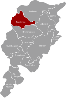
Location of Fürstenau in Höxter
|
|
Fürstenau is a town in North Rhine-Westphalia and belongs to the city of Höxter .
geography
The village with its 1185 inhabitants (2018) is located about 8 km northwest of Höxter. The Köterberg is located around 3 km northeast of Fürstenau .
history

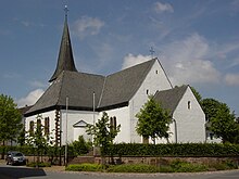
St. Anna Church in Fürstenau
Fürstenau was first mentioned in a document in 1241 on the occasion of an agreement on lease payments with the abbots of Marienmünster and Corvey .
On January 1, 1970, Fürstenau was incorporated into the district town of Höxter.
Population development
| year | Residents |
|---|---|
| 1821 | 480 |
| 1843 | 767 |
| 1864 | 762 |
| 1871 | 718 |
| 1885 | 751 |
| 1895 | 818 |
| 1910 | 814 |
| 1925 | 886 |
| 1933 | 964 |
| 1939 | 927 |
| 1946 | 1146 |
| 1961 | 1039 |
| 1969 | 1172 |
| 2007 | 1384 |
| 2008 | 1337 |
| 2009 | 1331 |
| 2010 | 1318 |
| 2011 | 1304 |
| 2012 | 1269 |
| 2013 | 1260 |
| 2015 | 1186 |
| 2016 | 1165 |
| 2017 | 1187 |
| 2018 | 1185 |
societies
| society |
|---|
| Spielmanns- und Fanfarenzug Fürstenau from 1930 eV |
| Parish scout Fürstenau eV |
| SV Fürstenau / Bödexen eV |
| Craftsmen's Association Fürstenau |
| Fürstenau shooting guild |
| KFD (Mothers' Association) |
| Local and tourist association Fürstenau |
| Fürstenau volunteer fire department |
| (Church) choir community Cäcilia Fürstenau |
| Fürstenau pigeon and rabbit club |
| Küffhäuser Fürstenau |
| Free parish youth Fürstenau |
| Fürstenau cultural association |
Web links
Commons : Fürstenau - collection of images, videos and audio files
Individual evidence
- ↑ a b c City portrait Höxter
- ↑ a b Figures on the website of the city of Höxter 2016
- ↑ Martin Bünermann: The communities of the first reorganization program in North Rhine-Westphalia . Deutscher Gemeindeverlag, Cologne 1970, p. 108 .
- ↑ Statistical-topographical overview of the government district of Minden 1821. In: Digital Collections ULB Münster. P. 34 ff , accessed on March 3, 2014 .
- ↑ Geographical-statistical-topographical overview of the administrative district of Minden 1845
- ^ Topographical-statistical manual of the government district of Minden 1866
- ^ The municipalities and manor districts of the Province of Westphalia in 1871
- ^ Community encyclopedia for the province of Westphalia 1885
- ^ Community encyclopedia for the province of Westphalia: 1895 population census
- ↑ Municipal directory 1900: District Höxter
- ^ A b c Michael Rademacher: German administrative history from the unification of the empire in 1871 to the reunification in 1990. hoexter.html. (Online material for the dissertation, Osnabrück 2006).
- ↑ 1946 census
- ↑ Martin Bünermann, Heinz Köstering: The communities and districts after the municipal territorial reform in North Rhine-Westphalia . Deutscher Gemeindeverlag, Cologne 1975, ISBN 3-555-30092-X , p. 187 .
- ↑ Martin Bünermann, Heinz Köstering: The communities and districts after the municipal territorial reform in North Rhine-Westphalia . Deutscher Gemeindeverlag, Cologne 1975, ISBN 3-555-30092-X , p. 106 .
- ↑ a b c d e f g City of Höxter> Fürstenau website

