
Köterberg
| Köterberg
(formerly: Keutersberg)
|
||
|---|---|---|
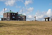
 View from the north to the Köterberg, with the Köterberg telecommunications tower |
||
| height | 495.8 m above sea level NHN | |
| location | between Lügde and Höxter ; Circles lip and Hoexter , district of Holzminden ; North Rhine-Westphalia , Lower Saxony ( Germany ) | |
| Mountains | Lipper mountain country | |
| Dominance | 17.8 km → Vogelherd ( 507 m , southwest of the Great Ahrensberg , Solling ) | |
| Notch height | 289 m ↓ south of Bredenborn | |
| Coordinates | 51 ° 51 ′ 19 ″ N , 9 ° 19 ′ 27 ″ E | |
|
||
| particularities | - Highest mountain in the Lipper Bergland - Köterberghaus - Köterberg telecommunications tower |
|
 View from Holzminden in the east-southeast to the Köterberg |
||


The Köterberg , formerly also called Keutersberg , is 495.8 m above sea level. NHN is the highest mountain in the middle part of the Weserbergland on the border of North Rhine-Westphalia and Lower Saxony situated Lipper Bergland . It lies between Lügde and Höxter on the border of the North Rhine-Westphalian districts of Lippe and Höxter and the district of Holzminden in Lower Saxony .
In the German Main Triangle Network (DHDN), the Köterberg is the main triangle point with the name Lügde, Köterberg . The mountain can often be seen from afar, for example from the Brocken in the Harz Mountains, which is almost 90 km away (as the crow flies ) . It is also often a good prospect . The mountain restaurant Köterberghaus and the telecommunications tower Köterberg as well as two other transmission towers are on the mountain .
geography
location
The Köterberg rises with its North Rhine-Westphalian parts in the Teutoburg Forest / Eggegebirge nature park . The mountain peak belonging to the urban area of Lügde is 12.6 km south-southeast of the city center and 9.8 km north-north-west of the city center of Höxter ; both in North Rhine-Westphalia. While the summit and major parts of the mountain are in North Rhine-Westphalia, a narrow, but extending to the south-western part of the summit region, which runs in the lower part in the valley of a source stream from the Weser tributary Lonaubach , belongs to Lower Saxony; the area of the patch Polle , the core of which is 7.5 km from the summit, extends to there . At the tip of this point, the North Rhine-Westphalian districts of Lippe in the north and Höxter in the south meet with the Lower Saxony district of Holzminden in the east. This tip is about 90 m southwest of the trigonometric point located on the summit region at 474.5 m above sea level. NHN ; there is a three-man stone ( ⊙ ).
On the north-northwest slope of the mountain is the Lüdger district Köterberg , just to the west of it springs the Niese . The Lonaubach flows from the eastern flank. At the southern foot lies the Höxter district of Bödexen , which is traversed by the Mühlenbach , a tributary of the Saumer that strives towards the Weser . The mountain is forested, its summit region only in the north.
Natural allocation
The Köterberg belongs to the natural spatial main unit group of Lower Saxony Bergland (with Weser and Leine Bergland ; number D36) or in the main unit Lipper Bergland (364) in the southern Lipper Bergland (364.3) to the natural area Schwalenberger Heights (364.37).
geology
The Köterberg is part of the Lipper mountainous region, which is characterized by shell limestone and Keuper . It is built using sandstones and marl from the Upper Keuper .
history
The Köterberg is first mentioned in a document in 1430. In the Lippe border files there is an entry from the 16th century.
In 1536, the Paderborn Bishop Hermann V. von Wied (also Archbishop of Cologne), Duke Ernst I of Braunschweig-Lüneburg and Simon V. Graf zur Lippe signed a contract on joint mining rights and a fair on the Köterberg. Already in 1520 two miners had been working on the Köterberg, but were unsuccessful. In 1543 Hermann von der Malsburg tried again to mine gold, silver, copper and lead at the Köterberg, but without success.
Karl Ludwig Edler von Lecoq included the Keutersberg between 1796 and 1801 as a triangular point in his military- topographical maps. In 1814 Wilhelm Grimm climbed the Köterberg. In 1816, the Brothers Grimm called the Köterberg in their German sagas (nos. 9, 20) Götzenberg , because the gods of the heathen were worshiped there. Her fairy tale The Three Little Birds is set there .
In 1831/1832 the first massive structure was erected on the highest peak of the mountain, a 15½ foot (approx. 4.9 m) high tower as a triangular signal of the first order for triangulation . The Köterberg was a station of the Prussian optical telegraph , which from 1832 to 1849 connected Berlin and Koblenz for communications . In 1929 the tower was blown up.
In 1939 the construction of a war memorial was planned on the Köterberg. In 1945, at the end of World War II, the Köterberg was used as an artillery position for the US Army.
From 1960 to 1962, a detachment of the US 585th Communications and Guidance Squadron (CGS) of the USAFE from Bitburg was stationed on the Köterberg . The ground station served as route guidance for the nuclear-armed cruise missiles of the MGM-1 Matador type , which were retired in 1962.
During the Cold War , the Köterberg was also involved in several military maneuvers by the British Army on the Rhine (BAOR), including the Eternal Triangle maneuver in 1983 .
The transmitter systems on the Köterberg (KBG) also served as military radio for the radio link to West Berlin through Troposcatter and between the transmitter systems on the Bocksberg (Harz) (BBG) and Rothwesten (RWN) as well as Dörenberg (Linderhofe; LDF) and on its infrastructure An 18-month test on digital microwave transmission network performance and propagation measurement (Digital European Backbone; DEB) was also carried out by the US Department of Commerce by 1989.
In 1993 the Köterberg Relay Station operated by the 104th Area Support Group of the United States Air Forces in Europe (USAFE) and the Köterberg Terminal Station (KOG) used by the 5th Signal Command of the US Army with headquarters in the US Garrison Mannheim were closed .
Köterberghaus
From June 7th to October 2nd, 1929 the Köterberghaus was built in the form of a Silesian mountain hut. The foundation was built from the stones of the tower from 1893, which was blown up when construction began. The Ströhl family was the first tenant of the economy located there. In 1935 Rudolf Brand took over the catering business as a leaseholder and after his death from 1968 to 1985 his wife Alma Brand took over the business. 1985 it was handed over to Rudolf Brand jun., Who in the same year bought the building from the Landesverband Lippe (LVL). In the long history of the Köterberghaus there have been numerous visits from personalities, including Bernhard zur Lippe-Biesterfeld , Konrad Adenauer and many NATO generals during the Cold War .
Köterberghaus

View of the Köterberghaus from the parking lot

Under the terrace


Towers
Telecommunication tower Köterberg
The 100 m high Köterberg telecommunications tower, which stands on the Köterberg, was built in 1971 as a type tower by the Deutsche Bundespost and is now used for broadcasting radio programs in the DAB + standard as well as wireless telephone traffic.
Digital radio ( DAB / DAB + ):
Since August 7, 2019, digital radio has been broadcast in vertical polarization in the single frequency network with other transmitters.
Transmission towers
There are two more transmission towers on the mountain for directional radio , as police , fire brigade and amateur radio relays as well as for Bundeswehr radio. The 70 cm amateur radio relay with the amateur radio call sign DB0KB transmits on the frequency 439.425 MHz. The coupling to the DB0WUR relay on the Wurmberg in the Harz Mountains is in operation at times. The US Army Communications Engineering and Installation Agency (USACEIA) installed a radio and radio system here from May 1984 to May 1985. Radio amateurs use the summit region because of the favorable transmission and reception conditions.
Possibility of viewing
Because the extensive summit region of the Köterberg, which can be approached via a cul-de-sac from Lügde-Köterberg, is almost unwooded, there is probably the best (almost) all-round view not only in the border area of the aforementioned federal states, but even up to, for example to the Habichtswald and Kaufunger Wald in northern Hesse and to the Harz , which is located in Lower Saxony , Saxony-Anhalt and Thuringia .
For example, you can see:
- Biesterfeld in the northwest
- Desenberg near Warburg
- the resin with the lump
- Holzminden
- the Kaufunger forest
- Höxter
- the high Habichtswald with the Hercules
- the Eggegebirge with the Externsteinen
- the Teutoburg Forest with the Hermannsdenkmal
Because of the good prospect and above all because of its exposed location, both of which are similar to the Brocken in the Harz Mountains, the Köterberg gives the impression of being the highest point in the Weser Uplands, although the Solling has four peaks ( Great Pale , Great Ahrensberg , Moosberg , Vogelherd). towers over; however, these peaks are all heavily forested, quite inconspicuous and not easily recognizable from a distance. The Köterberg is therefore also referred to as the "Brocken of the Weserbergland".
- Views from the Köterberg

Towards Holzminden

Direction Höxter
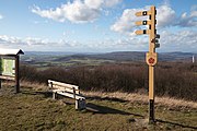
Direction Bad Pyrmont

Towards Hameln


tourism
In the summer months, numerous motorcyclists meet at the summit region to talk about petrol on the weekends , which often leads to a considerable number of motorbikes in the parking lot. Likewise, athletically ambitious cyclists ride the Köterberg. There is a restaurant in the Köterberghaus.
Oddities
On two signs at the Köterberghaus, the height of the actually 495.8 m high Köterberg is incorrectly stated as "500 m above sea level" , which can occasionally be found in literature and advertising.
The Köterberg is also jokingly referred to as Monte Wau-Wau . In the meantime this term has been picked up by tourists. At the summit, a 5 euro cent coin can be minted into a plaque with the words Monte Wau-Wau on the top . This plaque also shows the Köterberg exit sign, a dachshund leaning on its hind paws and the Weserbergland lettering in the lower area .
traffic

North-west past the Köterberg runs from Falkenhagen south-south-east through Köterberg and then westwards to Niese the county road 69, from which the Köterberg road , also known as K 69, leads as a spur road to the summit region in the village of Köterberg . It has a maximum gradient of 14 percent.
Panoramic photo

References and comments
- ↑ a b c d Topographical Information Management, Cologne District Government, Department GEObasis NRW ( information )
- ↑ dominance and prominence according to TK 25; Scharte is about 207 m high
- ↑ Environment map service of the Lower Saxony Ministry for the Environment, Energy and Climate Protection ( notes ) (height information interpolated from contour map).
- ^ The main triangle point Köterberg in the mirror of geodetic observations , from 1988, accessed on January 31, 2017, on uni-bonn.de
- ↑ 1983 Eternal Triangle , accessed on January 28, 2017, from military-database.de
- ^ US Department of Commerce - National Telecommunications and Information Administration Report 89–247: Digital European Backbone Performance: A 12-Month Summary for the Frankfurt North Segment , J. A. Hoffmeyer, T. J. Riley, August 1989
- ↑ Digital radio: new transmission systems for the federal mux | dehnmedia.de from August 7, 2019
- ↑ Monte-Wau-Wau badge (photo), on commons.wikimedia.org
literature
- Gerking, Willy, 75 years of Köterberghaus. His story in the mirror of the guest books, in: Heimatland Lippe (Zeitschrift des Lippischen Heimatbundes, Detmold), No. 4/2004, pp. 44–77, No. 7/2004, pp. 141–145.
- Wienke, Martin, The Köterberg in the Weserbergland. Detmold 1978.
Web links
- Köterberg (Berghotel Köterberg) , on koeterberg.de
- Homepage of DB0KB. Archived from the original on December 29, 2011 ; Retrieved June 9, 2016 . , (70 cm amateur radio relay)