Sneeze (emmer)
| Sneeze | ||
|
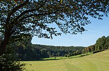
Niese near Kreienberg below Kollerbeck |
||
| Data | ||
| Water code | EN : 4568 | |
| location | North Rhine-Westphalia , Germany | |
| River system | Weser | |
| Drain over | Emmer → Weser → North Sea | |
| source | At Köterberg 51 ° 51 ′ 30 ″ N , 9 ° 19 ′ 1 ″ E |
|
| Source height | 377 m above sea level NN | |
| muzzle | At Schieder in the Emmer coordinates: 51 ° 55 '3 " N , 9 ° 8' 24" E 51 ° 55 '3 " N , 9 ° 8' 24" E |
|
| Mouth height | 118 m above sea level NN | |
| Height difference | 259 m | |
| Bottom slope | 10 ‰ | |
| length | 25.7 km | |
| Catchment area | 69.614 km² | |
| Discharge at the Schieder A Eo gauge : 69.34 km². Location: 560 m above the mouth |
NNQ (09/26/1997) MNQ 1981/2014 MQ 1981/2014 Mq 1981/2014 MHQ 1981/2014 HHQ (10/28/1998) |
101 l / s 191 l / s 772 l / s 11.1 l / (s km²) 12.2 m³ / s 31.5 m³ / s |
The Niese is a 25.7 km long, orographically right or eastern tributary of the Emmer in the Lippe district and in the Höxter district in North Rhine-Westphalia , Germany . It drains part of the Lipper Mountains .
course
The Niese rises at an altitude of about 377 m above sea level. NN west of the village of Köterberg on the western slope of the 495.8 m high Köterberg . From its source, the water flows west through the eponymous town of Niese (zu Lügde ) down to Kollerbeck . After flowing through Kollerbeck, the Niese turns to the northwest and flows south past Schwalenberg and touches Lothe before entering the Steinheimer Holz, a large wooded area. After leaving the Steinheimer Holz, the Niese flows west of Schieder at km 33.7 at an altitude of 120 m above sea level. NN on the right into the Weser tributary Emmer , which flows a few hundred meters further east through the Schiedersee .
environment
Water quality
In 2001 the Niese was assigned to water quality class II – III in the upper reaches . In the further course, the water quality improved to quality class II (moderately polluted). In 2008 the entire course of the river was assigned to quality class II. The Niese is polluted with nitrate and phosphates from discharges from the Kollerbeck and Niese sewage treatment plants and from livestock farming in the immediate vicinity of the water.
Nature reserves
The valley of the lower Niese and the mouth of the Niese were designated as a nature reserve in 1994 . The 240 hectare nature reserve “Nieseniederung mit Mündungsbereich” “extends for about 12.5 km from the border with the Höxter district southeast of Schwalenberg past the Lothe district to the area where the Niese meets the Emmer, north of Schieder, in the immediate vicinity of the Emmer reservoir . "This is a near-natural brook valley" with the predominantly near-natural flowing water course of the Niese, pronounced valley edges and extensive grassland areas with different levels of humidity. "
Tributaries
The Niese has several tributaries, which are listed below when viewed downstream:
- Papenhöfener Bach: 2.944 km long, left tributary, catchment area: 2.979 km²
- Steinbach: 6.073 km long, right tributary, catchment area: 7.054 km²
- Kleinenbredener Bach : 7.43 km long left tributary, catchment area: 12.636 km²
- Kotherbach: 2.867 km long, right tributary
- Lippebach: 4.368 km long right tributary
- Bärentalbach: 1.097 km long, right tributary
- Bennersiek: 1.396 km long right tributary
All length information according to the Land Survey Office of North Rhine-Westphalia
Hydrology
The State Office for Nature, Environment and Consumer Protection in North Rhine-Westphalia operates a gauge on the Niese in Schieder not far from the estuary and provides current level data online. This level is at the same time a water level. The mean discharge (MQ) at this level is 0.826 m³ / s, the low water discharge (MNQ) 0.182 m³ / s and the mean high water discharge 15.3 m³ / s. On August 28, 2008 the lowest discharge was measured with 0.053 m³ / s and the highest on October 28, 1998 with 44.2 m³ / s.
See also
Web links
Individual evidence
- ↑ a b German basic map 1: 5000
- ↑ a b Topographical Information Management, Cologne District Government, Department GEObasis NRW ( Notes )
- ^ German Hydrological Yearbook Weser-Ems 2014. Lower Saxony State Agency for Water Management, Coastal and Nature Conservation, p. 160, accessed on October 4, 2017 (PDF, German, 8805 kB).
- ↑ a b State Office for Nature, Environment and Consumer Protection North Rhine-Westphalia (2001) ( Memento of the original from September 25, 2011 in the Internet Archive ) Info: The archive link was inserted automatically and has not yet been checked. Please check the original and archive link according to the instructions and then remove this notice. (PDF; 941 kB)
- ↑ Water quality map district Lippe 2008
- ↑ a b Nature reserve “Nieseniederung mit Muendungsbereich” in the specialist information system of the State Office for Nature, Environment and Consumer Protection in North Rhine-Westphalia
- ↑ State survey office NRW
- ^ German Hydrological Yearbook Weser-Ems-Area 2003

