Office Höxter-Land
| coat of arms | Germany map | |
|---|---|---|

|
Coordinates: 51 ° 49 ' N , 9 ° 24' E |
|
| Basic data (as of 1969) | ||
| Existing period: | 1843-1969 | |
| State : | North Rhine-Westphalia | |
| Administrative region : | Detmold | |
| Circle : | Höxter | |
| Residents: | 16,267 (Dec. 31, 1967) | |
| Office structure: | 11 municipalities | |
The Office Höxter-Land , until 1930 Office Höxter-Albaxen , was an office in the East Westphalian district of Höxter in North Rhine-Westphalia that existed until 1969 .
Organization and population
The office was divided into the eleven municipalities of Albaxen , Bödexen , Bosseborn , Brenkhausen , Fürstenau , Godelheim , Lüchtringen , Lütmarsen , Ottbergen , Ovenhausen and Stahle , none of which had city rights. The administrative seat was the city of Höxter , which itself did not belong to the office.
At the last census before the dissolution of the office on May 6, 1961, the municipalities of the office had a resident population of 14,714. According to the extrapolation of the census results, this number rose to 16,267 inhabitants by the end of 1967. With an area of 123.16 km², the average population density was 132 inhabitants per square kilometer, which was just below the district average of 140 inhabitants per square kilometer. The following overview shows the eleven municipalities with population and territorial status as of December 31, 1967:
| Surname | Residents | Area in km² |
|---|---|---|
| Albaxen | 1,665 | 11.30 |
| Bödexen | 778 | 21.59 |
| Bosseborn | 557 | 10.32 |
| Brenkhausen | 1,401 | 13.20 |
| Fürstenau | 1,139 | 10.60 |
| Godelheim | 1,188 | 9.73 |
| Lüchtringen | 2,933 | 5.90 |
| Lütmarsen | 703 | 6.17 |
| Ottbergen | 2,199 | 7.71 |
| Ovenhausen | 1,251 | 17.49 |
| Steels | 2,453 | 9.16 |
| Office Höxter-Land | 16,267 | 123.16 |
geography
The office Höxter-Land was in the northeast of the district of Höxter. The office enclosed the city of Höxter to a large extent, apart from the eastern border of the city with the district of Holzminden . In addition to the city of Höxter, the offices of Beverungen , Brakel and Vörden (district of Höxter), the district of Detmold and the Lower Saxony districts of Hameln-Pyrmont and Holzminden bordered the office in a clockwise direction .
history
As part of the introduction of the rural community order for the province of Westphalia , the two offices of Höxter and Albaxen were set up in 1843 . The city of Höxter remained vacant and did not belong to the office of Höxter. The offices of Höxter and Albaxen have been administered in personal union since their establishment and have formed the combined office of Höxter-Albaxen since 1852 .
In 1930 the office of Höxter-Albaxen was renamed Höxter-Land . The administrative headquarters remained in Höxter.
Due to a field amendment agreement dated 19 December 1968, § 1 of the " Law on the reorganization of the district Hoexter " of 2 December 1969 which also confirms the area change agreement in § 8 para. 1, the communities of the Office joined with the municipality Bruchhausen the Office Beverungen and the city of Höxter merged to form the new city of Höxter on January 1, 1970. The Höxter-Land office was dissolved. The legal successor is the city of Höxter.
coat of arms
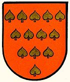
The coat of arms of the office of Höxter-Land depicted 13 linden leaves as a symbol after the epic Thirteen Linden (Friedrich Wilhelm Weber) .
Web links
- Law on the reorganization of the Höxter district of December 2, 1969
Individual evidence
- ↑ Landgemeinde -ordnung for the Province of Westphalia from October 31, 1841 (PDF; 1.6 MB)
- ^ Official Journal of the Minden Government 1843: Formation of the offices of Höxter and Albaxen. Retrieved March 3, 2014 .
- ^ Wolfgang Leesch: Administration in Westphalia 1815-1945 . In: Publications of the Historical Commission for Westphalia . tape 38 . Aschendorff, Münster 1992, ISBN 3-402-06845-1 .
