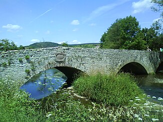
Nethe
The Nethe is a 50.4 km long, western and orographically left tributary of the Weser in the Oberwälder Land in the North Rhine-Westphalian district of Höxter ( Germany ).
The Nethe gives its name to the Nethegau , a former Saxon and then Carolingian district . The entire length of the Nethe course from source to mouth is part of the FFH area DE-4320-305 Nethe , because of its largely natural course and only minor hydraulic engineering interventions, with “well-developed bank and underwater vegetation”. For the city of Beverungen and Hoexter - Ottbergen the company plans Trianel the pumped storage power plant Nethe with 390 MW power.
geography
course
The Nethe rises in the east of the Eggegebirge in the Teutoburg Forest / Eggegebirge Nature Park . Its source is north of the center of the southern Bad Driburg district of Neuenheerse .
Shortly after leaving the village, the Nethe has been dammed in the 4.5 hectare Nethestausee since 1975 . Initially the river runs in a south-easterly direction and - after taking up the stream from the Eggequelle - through Willebadessen , after which it turns east. Afterwards it flows through or passes Fölsen and Niesen and then turns east of Gehrden to the north, with the federal highway 252 running along it. Through Siddessen , Rheder and east past Riesel , the Nethe, which is crossed by bridges of the B 64 and B 252, reaches Brakel . After passing it to the south, it flows further east. It flows through Erkeln , Beller , Hembsen , Bruchhausen and Ottbergen as well as Amelunxen , and from Brakel it is accompanied by the B 64.
After eastern passing Godelheim , a district of Hoexter , and the bridge of the federal highway 83 , the Nethe flows into the next there roughly from S Weser . It has an average water flow of 6.1 m³ / s here. The Eggebahn is also laid along the Nethe between Riesel and the estuary .
Catchment area and tributaries
The catchment area of the Nethe is 460.448 km² and extends from the Eggegebirge in the west over the Steinheimer Börde in the north to the Warburger Börde in the south. Its main tributaries are the Rickebach (Riekebach, Hellebach) in Willebadessen, the Helmerte near Fölsen, the Taufnethe in Niesen, the Öse in Siddessen, the Aa near Riesel and the Brucht near Brakel.
Rhine-Weser watershed
The headwaters of the Nethe lie on the Rhine-Weser watershed : While the water of the Sauer reaches the Rhine in predominantly western directions through the Altenau , Alme and Lippe , the Nethe flows mostly in eastern directions into the Weser .
fauna
In the Nethe the rare species of fish Koppe and brook lamprey , in the catchment area, the species red kite , kingfishers and the rare black stork .
Poetry: Thirteen Linden trees
The Nethe was sung about by the local poet Friedrich Wilhelm Weber at the beginning of his famous poem Dreizehnlinden (excerpt from Chapter II, Part 1) - From the Nethegau :
It is wonderful
to reach for the walking stick in spring days and to wander through
God's garden with
the bouquet of flowers on your hat
.
Above are the white clouds,
below are the blue brooks, the
forest and meadows are
beautifully dressed in new clothes
. ...
Individual evidence
- ↑ a b c d e f Topographical Information Management, Cologne District Government, Department GEObasis NRW ( information )
- ^ German Hydrological Yearbook Weser-Ems 2014. Lower Saxony State Agency for Water Management, Coastal and Nature Conservation, p. 156, accessed on October 4, 2017 (PDF, German, 8805 kB).
- ↑ a b Gauge value Ottbergen increased by the area runoff of the remaining catchment area (10.1 / s.km² to 27.95 km²), derived from the values of the enclosing intermediate catchment area of the gauges Karlshafen (Weser), Ottbergen (Nethe), Negenborn (Forstbach) and Bodenwerder (Weser) and from the Hydrological Atlas of Germany - Annual discharge height
- ↑ Natura 2000 area "DE-4320-305 Nethe (FFH)" in the specialist information system of the State Office for Nature, Environment and Consumer Protection in North Rhine-Westphalia
- ↑ Friedrich Wilhelm Weber: Dreizehnlinden - Chapter 2 , on projekt-gutenberg.org
Web links
- Water analysis: 452 Nethe , 1999 (PDF file; 56.2 kB)


