Sauer (Altenau)
| Angry | ||
|
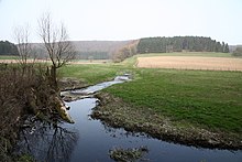
At the eastern entrance to the village of Grundsteinheim , the |
||
| Data | ||
| Water code | DE : 278284 | |
| location | Paderborn district , North Rhine-Westphalia ( Germany ) | |
| River system | Rhine | |
| Drain over | Altenau → Alme → Lippe → Rhine → North Sea | |
| source | in the Egge Mountains near Kleinenberg 51 ° 36 ′ 7 ″ N , 8 ° 59 ′ 34 ″ E |
|
| Source height | 367 m above sea level NHN | |
| muzzle | near Atteln in Altenau coordinates: 51 ° 35 ′ 59 ″ N , 8 ° 48 ′ 16 ″ E 51 ° 35 ′ 59 ″ N , 8 ° 48 ′ 16 ″ E |
|
| Mouth height | 189 m above sea level NHN | |
| Height difference | 178 m | |
| Bottom slope | approx. 5.9 ‰ | |
| length | approx. 30 km | |
| Catchment area | 109.627 km² | |
The Sauer is an approximately 30 km long, north-eastern and orographically right tributary of the Altenau in the North Rhine-Westphalian district of Paderborn ( Germany ).
course
The Sauer rises in the southern part of the Eggegebirge and Teutoburg Forest / Eggegebirge Nature Park in the urban area of Lichtenau . Its source is north-east of the Kleinenberg district a little above the state road 763.
Initially, the Sauer , which runs completely in the Lichtenau urban area and the Teutoburg Forest / Eggegebirge nature park, and mostly on the Paderborn plateau , flows roughly to the west, where it passes the ancient railway monument located a little to the north and then runs through the three fish ponds near Schönthal . After that, after flowing through the Sauerbachtal Bülheim nature reserve (NSG no. 165330), which was founded in 1938 and is around 49 hectares in size, and a pond near Gut Bülheim , it crosses federal road 68 .
Thereafter, the Sauer turns to the north-west and extends in the undulating plateau Soratfeld ( withered field) by the multi-part nature reserve Sauertal (NSG no. 319051) made since 2000 and about 927 ha, and after flowing through the flood retention basin Sudheim by the Lichtenau core town. There it is bridged again by the B 68 and this is where the Odenheimer Bach flows from the east .
Then the Sauer bends southwest between the Lichtenau district of Iggenhausen and the Lichtenau district of Grundsteinheim, which is not adjacent to it ; the Schmittwasser flows in between the two villages, coming roughly from the east . Shortly afterwards it flows through Grundsteinheim and then crosses under the B 68 for the last time. It then flows southwest to and through the Ebbinghausen district of Lichtenau and leaves the Sauertal nature reserve .
A little after flowing through the Ebbinghausen flood retention basin below Ebbinghausen , the Sauer flows directly north of the Atteln district of Lichtenau at the Altenautal outdoor pool into the Alme tributary of Altenau , which is rich in water and, with a 13.25 km stretch, is much shorter than the Sauer.
Water flow
In summer , large parts of the Sauer are mostly dry. So the stream seeps away behind Lichtenau in Ponore . The water that seeps away there comes back to the surface in the Pader springs . Through the already mentioned Schmittwasser, which flows in between Grundsteinheim and Iggenhausen, this also carries water in Grundsteinheim in summer. At the exit of Grundsteinheim the water seeps away again, so that it does not lead to any water until it flows into the Altenau. In winter or when it rains heavily, the stream carries water along its entire length. When the snow melts or when it rains, the water level in the Sauer is sometimes so high that you can go canoeing .
Flood
In the summer of 1965 in particular, the Sauer overflowed its banks and flooded large parts of the neighboring villages. As a result, two flood retention basins (HRB) were built to absorb excess acid water during floods : the HRB Sudheim (built between 1978 and 1980; 2.511 million m³ storage space ) a little above Lichtenau or from Gut Sudheim and the HRB Ebbinghausen a little below Ebbinghausen (1974 to 1976; 2.38 million m³).
Watershed
The headwaters of the Sauer are located on the Rhine-Weser watershed : This means that the Sauer, which flows in western directions, drains into the Rhine via the Altenau , Alme and Lippe , while the flowing waters that flow on the southeast and Rise on the east side of the ridge over which the Diemel and Nethe flow into the Weser .
Tributaries and catchment areas
The tributaries of the Sauer, whose catchment area covers 109.627 km², include with orographic allocation (l = left-hand side, r = right-hand side) , length of the river, etc. a. Estuary with Sauerbach kilometers (viewed downstream) :
- Brook from Kleinenberg (l, 5.6 km), above Lichtenau (at km 24.5)
- Odenheimer Bach (r; 6.3 km), in Lichtenau (at km 19.15)
- Schmittwasser (also called Glasebach or Glasewasser in the lower reaches ; r; 8.8 km), above Grundsteinheim (at km 13.1)
Localities
The localities on the Sauer are (viewed downstream):
Web links
- Sauertal nature reserve near Paderborn on YouTube ; Film by the NRW Foundation with a sequence about swallow holes
Individual evidence
- ↑ a b German basic map (DGK 5) in Topographical Information Management, Cologne District Government, Department GEObasis NRW ( information )
- ↑ a b c Topographical Information Management, Cologne District Government, Department GEObasis NRW ( information )
- ↑ a b c Map services of the Federal Agency for Nature Conservation ( information )
- ↑ a b map service of the water association Obere Lippe , on wol.biz

