
Iserlohn district
| coat of arms | Germany map | |
|---|---|---|

|
Coordinates: 51 ° 23 ' N , 7 ° 40' E |
|
| Basic data (as of 1974) | ||
| Existing period: | 1817-1974 | |
| State : | North Rhine-Westphalia | |
| Administrative region : | Arnsberg | |
| Regional association : | Westphalia-Lippe | |
| Administrative headquarters : | Iserlohn | |
| Area : | 338.72 km 2 | |
| Residents: | 211,100 (Dec. 31, 1973) | |
| Population density : | 623 inhabitants per km 2 | |
| License plate : | IS | |
| Circle key : | 05 8 35 | |
| Circle structure: | 26 municipalities | |
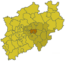
| Location of the Iserlohn district in North Rhine-Westphalia | ||
  |
||

The circle Iserlohn was a circle in North Rhine-Westphalia , Germany . It was located in the northwest of the Sauerland and belonged to the administrative district of Arnsberg . The district bordered in a clockwise direction on the Unna district , the Soest district , the Arnsberg district , the Altena district , the Ennepe-Ruhr district , the independent city of Hagen and the independent city of Dortmund . The independent city of Iserlohn (also the district town) formed an enclave in the district (so-called collar district ).

geography
location
The Iserlohn district was located in the heart of North Rhine-Westphalia on the middle reaches of the Ruhr and lower reaches of the Lenne in the west and the Hönne in the east. The lowest point was 91 m above sea level. NN in the Ruhr valley on the district border in Westhofen , the highest point was the 493.9 m high Rüssenberg in Iserlohn- Kesbern .
history
historical development

The Iserlohn district was founded in 1817 by Prussia in the Arnsberg administrative district of the Westphalia province . It emerged from different historical territories:
- the county of Limburg with Limburg, Elsey, Berchum, Ergste, Letmathe, Oestrich, Hennen and Henkhausen
- Divide the county of Mark with Iserlohn and the Amt Hemer
- the western part of the Duchy of Westphalia with the city and the office of Menden and Balve
The seat of the district was for one year at Melschede Castle near Langscheid . The lord of the castle, Friedrich Freiherr von Wrede zu Melschede, was elected the district's first district administrator on February 19, 1817. After a short time he gave up the office. His successor Peter Eberhard Müllensiefen from Iserlohn was introduced on November 13, 1817. In 1818 the district seat changed to Iserlohn.
The district area initially covered 603 km². The population of 15,129 inhabitants was spread over 179 villages. In 1819 and 1832 several communities were given to the Arnsberg district :
- Echthausen , Vosswinkel , Holzen , Enkhausen and Langscheid to the Hüsten office
- Affeln , Altenaffeln , Asbeck , Blintrop , Balve , Eisborn , Volkringhausen , Beckum , Mellen , Garbeck , Langenholthausen and Küntrop to the Balve office as well
- Amecke , Allendorf , Stockum , Hagen and Endorf to the Sundern office
The district council had 20 mandates and was composed of four estates. The Prince of Bentheim-Tecklenburg had one mandate, the manor owners had eleven mandates and the four cities of the district and the representatives of the rural communities each had four mandates. Politics was disproportionately oriented towards the interests of the manor owners. A representation of the municipalities was not possible, the principle of "self-government of the districts" was not clear to the population. The supremacy of the manor owners was only removed with the amendment to the district regulations of July 31, 1886. This enabled the idea of self-administration to be realized.
In the 1830s the district was divided into the five mayorships Ergste, Hemer, Iserlohn, Limburg and Menden. As part of the introduction of the rural community order for the province of Westphalia, the mayor's offices were transferred to offices in 1843 and 1844 , with the cities of Iserlohn and Menden remaining vacant. From that time on, the district initially comprised four offices and a total of 30 communities:
| Administrative division since 1844 | |
|---|---|
| Office | Communities |
| Ergste | Berchum , Ergste and Hennen |
| Hemer | Becke , Brockhausen , Deilinghofen , Evingsen , Frönsberg , Ihmert , Calle , Kesbern , Landhausen , Lössel , Niederhemer , Oberhemer , Sundwig and Westig |
| Limburg | Elsey , Letmathe , Limburg and Oestrich |
| Menden | Böingsen , Halingen , Holzen , Oesbern , Schwitten , Sümmern and Wimbern |
| free of charge | Iserlohn and Menden |

The name of Limburg was changed to Hohenlimburg in 1879 and in 1902 Elsey was incorporated into the city of Hohenlimburg, which at the same time became vacant. Letmathe and Oestrich, the two remaining municipalities of the Limburg office, now formed the Letmathe-Oestrich office . The city of Iserlohn became a district in 1907, but remained a district seat. The Iserlohn district has been called the Iserlohn district since then . Niederhemer and Oberhemer merged in 1910 to form the municipality of Hemer .
In 1922 Letmathe formed its own office and Oestrich formed the new Oestrich office with the municipality of Lössel, which was separated from the office of Hemer . In 1929 the town of Schwerte and the Westhofen office moved from the dissolved Hörde district to the Iserlohn district, and Brockhausen was incorporated into Deilinghofen, Calle to Iserlohn and Landhausen, Sundwig and Westig after Hemer. The Letmathe office was abolished in 1934. In 1936 Hemer and Letmathe were granted city rights, with Hemer now also becoming an office-free city. In the same year Böingsen was renamed Lendringsen .
In 1956 the Oestrich office was dissolved and most of it was added to the town of Letmathe. The rest of the office, including Iserlohner Heide , Gerlingsen , Hombruch and Nussberg, went to the city of Iserlohn. In 1969 Berchum was incorporated into Hohenlimburg. At the same time Evingsen were incorporated into Altena in the Lüdenscheid district and Wimbern to Wickede (Ruhr) in the Soest district .
On October 1, 1969, the district became the Iserlohn district.
Circle structure before dissolution
The Iserlohn district last consisted of 6 cities and 4 offices with 20 communities. As of December 31, 1972, the district area with a size of 338.63 km² was distributed among the individual communities with a total of 207,158 inhabitants as follows:
| local community | Official affiliation | Area in km² | Population 1972 | Population 2002 | City / district from 1975 |
|---|---|---|---|---|---|
| Menden 1, 2 | no | 19.10 | 30,391 | 60,088 | Menden (Sauerland) - Märkischer Kreis |
| Letmathe 1 | no | 35.41 | 27,195 | 27,683 | Iserlohn - Märkischer Kreis |
| Hohenlimburg 1, 3 | no | 18.37 | 26,423 | 27,423 | Independent city of Hagen |
| Swords 1 | no | 10.91 | 24,288 | 52,816 | Schwerte - Unna district |
| Hemer 1, 2 | no | 27.00 | 24,790 | 37,346 | Hemer - Märkischer Kreis |
| Berchum 3 | Office Ergste | 6.42 | 1,638 | 5.132 | Independent city of Hagen |
| Ergste 2 | Office Ergste | 19.00 | 4,854 | 7,533 | Schwerte - Unna district |
| Hens | Office Ergste | 32.80 | 7.141 | 9,801 | Iserlohn - Märkischer Kreis |
| Basin | Office of Hemer | 5.52 | 1,387 | Hemer - Märkischer Kreis | |
| Deilinghofen | Office of Hemer | 18.84 | 4,578 | Hemer - Märkischer Kreis | |
| Frönsberg | Office of Hemer | 6.04 | 699 | Hemer - Märkischer Kreis | |
| Himert | Office of Hemer | 11.53 | 4,055 | Hemer - Märkischer Kreis | |
| Kesbern | Office of Hemer | 13.24 | 478 | 495 | Iserlohn - Märkischer Kreis |
| Evil earth | Menden Office | 6.19 | 3,283 | 3,066 | Menden (Sauerland) - Märkischer Kreis |
| Halingen | Menden Office | 11.02 | 1,541 | 1.961 | Menden (Sauerland) - Märkischer Kreis |
| Sirloin | Menden Office | 19.54 | 14,320 | 14,273 | Menden (Sauerland) - Märkischer Kreis |
| Oesbern | Menden Office | 10.84 | 822 | 605 | Menden (Sauerland) - Märkischer Kreis |
| Schwitten | Menden Office | 11.61 | 2,215 | 2,468 | Menden (Sauerland) - Märkischer Kreis |
| Mourn | Menden Office | 15.18 | 3,631 | 7.070 + 257 ( East-S. ) | Iserlohn and Menden (Sauerland) - Märkischer Kreis |
| Garenfeld | Westhofen office | 4.98 | 1,124 | Independent city of Hagen | |
| Geisecke | Westhofen office | 4.19 | 1,212 | 2,738 | Schwerte - Unna district |
| Wood | Westhofen office | 7.52 | 7,852 | 4,947 + 6,870 ( DO ) | Schwerte - Unna and Dortmund districts |
| Lichtendorf | Westhofen office | 4.88 | 2,975 | 395 + 2,647 ( DO ) | Schwerte - Unna and Dortmund districts |
| Villigst | Westhofen office | 6.95 | 2,970 | 3,587 | Schwerte - Unna district |
| Wandhofen | Westhofen office | 3.15 | 1,402 | 2,330 | Schwerte - Unna district |
| Westhofen 1, 2 | Westhofen office | 8.41 | 5,894 | 6,047 | Schwerte - Unna district |
1 Cities
2 Official seats
3 Berchum has belonged to the city of Hohenlimburg since 1969, here the numbers according to the old territorial division are in
italics: based on today's urban area
On March 1, 1973, the independent city of Iserlohn had an area of 30.81 km² and 57,145 inhabitants. (In 2008 there were 95,598 inhabitants in today's urban area).
Dissolution of the circle
The Iserlohn district was dissolved on January 1, 1975, and most of the area was merged with the former Lüdenscheid district and the independent city of Iserlohn as well as with the area of today's town of Balve from the former Arnsberg district to form the newly formed Märkischer Kreis . The area of today's city of Schwerte went to the Unna district , the previously independent city of Hohenlimburg became a district of the independent city of Hagen . All offices were dissolved. Iserlohn became the largest city in the new district through incorporations, in particular Letmathe, but lost the district seat to Lüdenscheid.
Population development
| year | Residents | source |
|---|---|---|
| 1819 | 24,336 | |
| 1832 | 27,131 | |
| 1871 | 53,350 | |
| 1880 | 61,000 | |
| 1890 | 70.002 | |
| 1900 | 85.506 | |
| 1910 | 71,921 | |
| 1925 | 81,974 | |
| 1939 | 118.710 | |
| 1950 | 157.908 | |
| 1960 | 181,200 | |
| 1970 | 200,300 | |
| 1973 | 211.100 |
politics
Results of the district elections from 1946
The list only shows parties and constituencies that received at least two percent of the votes in the respective election.
Share of votes of the parties in percent
| year | SPD | CDU | FDP | DZP | BHE | KPD |
|---|---|---|---|---|---|---|
| 1946 | 41.1 | 40.5 | 2.7 | 9.7 | 6.0 | |
| 1948 | 41.3 | 34.0 | 4.3 | 13.8 | 5.9 | |
| 1952 | 37.7 | 28.7 | 13.5 | 10.9 | 4.1 | 3.6 |
| 1956 | 43.5 | 33.3 | 10.8 | 8.2 | 3.8 | |
| 1961 | 42.0 | 44.1 | 11.5 | |||
| 1964 | 46.5 | 43.7 | 8.2 | |||
| 1969 | 47.6 | 46.3 | 4.7 |
District administrators
- 1817: Friedrich von Wrede
- 1817–1835: Peter Eberhard Müllensiefen
- 1836–1862: Ludwig Schütte
- 1862–1876: August Overweg
- 1877–1887: Maximilian Löbbecke
- 1887–1919: Ullrich Nauck
- 1919–1932: August Loos
- 1932-1935: Hans Storck
- 1935–1939: Karl von Rumohr (NSDAP)
- 1939–1945: Erich Ebel (NSDAP)
- 1945: Richard Klewer
- 1945–1946: Werner Jacobi ( SPD )
- 1946–1948: Paul Grote (CDU)
- 1948–1952: Martin Volmert (center)
- 1952–1954: Josef Vieler (CDU)
- 1954–1956: Stephan Mias (FDP)
- 1956–1961: Hugo Höppe (SPD)
- 1961–1969: Fritz Willmes (CDU)
- 1969–1974: Willy Haarmann (CDU)
Upper District Directors
- 1946–1963: Friedrich Lücking (SPD)
- 1963–1974: Jürgen Albath (CDU)
coat of arms
|
|
The coat of arms of the district of Iserlohn tried to unite all territorial conditions:
|
District partnerships
- Wrexham County Borough , North Wales (since 1970)
traffic
The federal highways and railway lines as of December 31, 1974 are shown below.
Federal trunk roads
- A 1 (Hansalinie) Cologne - Schwerte - Hamburg - Lübeck
- A 45 (Sauerland line) Dortmund– Ergste –Gießen
- A 46 Hagen– Hohenlimburg – Iserlohn-West
- B 7 Düsseldorf– Hohenlimburg – Iserlohn – Hemer – Menden –Kassel
- B 63 Wimbern –Werl – Hamm
- B 233 Iserlohn – Hennen –Unna – Werne
- B 236 Olfen– Schwerte – Ergste – Letmathe –Winterberg – Wetter (Hess.)
- B 515 Balve– Lendringsen – Menden – Bösperde – Halingen –Langschede
Railway lines

- Hagen– Schwerte –Hamm (Westphalia) ( Hagen – Hamm railway )
- Hagen– Schwerte –Arnsberg – Warburg (Westphalia) ( Upper Ruhr Valley Railway )
- Iserlohn - Swords - Dortmund ( Ardey Railway )
- Letmathe –Iserlohn– Iserlohn Ost - Hemer - Menden –Fröndenberg ( Letmathe – Fröndenberg railway )
- Hagen– Hohenlimburg –Letmathe –Altena (Westphalia) - Finnentrop – Altenhundem – Hüttental-Weidenau – Siegen ( Ruhr-Sieg route )
- Unna – Fröndenberg– Menden –Neuenrade ( Hönnetalbahn )
Education, culture and sights
Supra-local educational institutions
- University of Applied Sciences South Westphalia , headquarters in Iserlohn (until December 31, 2001: Märkische Fachhochschule)
- Theodor Reuter Vocational College Iserlohn
theatre
- Parktheater Iserlohn
Museums

- Iserlohn City Museum "House of Home", Iserlohn
- Varnhagensche Library , Iserlohn
- Historic Maste-Barendorf factory complex , Iserlohn (needle museum, brass, artist workshops)
- Iserlohn Museum for Crafts and Postal History , Iserlohn
- German Cave Museum , Iserlohn
- Municipal Museum Haus Letmathe , Iserlohn
- Ruhr Valley Museum Schwerte
- Speleological Museum, Hemer
- German Cold Rolling Museum Hohenlimburg (now the city of Hagen)
- Local museums in every city
Galleries
- Municipal gallery Iserlohn
- Villa Wessel , Iserlohn - art exhibitions
- Bengelsträter Gallery, Iserlohn
- Gallery in the Parktheater Iserlohn
music
- Municipal music school Iserlohn
- Iserlohn autumn days for music, international master classes
- Iserlohn Guitar Symposium (annually)
- Henkelmann jazz club of the "Hot Club Iserlohn" (oldest German jazz club)
- Iserlohn Organ Weeks (annually)
Buildings and cultural monuments

- Danzturm Iserlohn
- Bismarck Tower Iserlohn
- Supreme town church Iserlohn
- Farmer's Church Iserlohn
- Evangelical Church Iserlohn-Hennen
- House Letmathe in Iserlohn-Letmathe ( manor house )
- Old town Iserlohn (with city wall)
- Hohenlimburg Castle (now the city of Hagen)
- Dahlhausen Castle (Menden-Halingen)
- Old town hall Schwerte
- Hemer House (old manor house)
- Old waterworks (Westhofen)
- Ruin house Berchum

Natural monuments
- Dechen Cave Iserlohn
- Heinrichshöhle Hemer
- Father and Nun (Iserlohn-Oestrich)
- Stone Age sites (Iserlohn-Grürmannsheide)
- Rock Sea Hemer
- Lenneauen (Garenfeld, now the city of Hagen)
License Plate
On July 1, 1956, the district was assigned the distinctive sign IS when the vehicle registration number was introduced. It was issued until January 1975 (in January 1975 with the combination IS-MK ).
swell
- August Overweg: Statistical description of the Iserlohn district. Iserlohn, 1875 digitized
literature
- Sauerland-Verlag Iserlohn: The district of Iserlohn. A dynamic living space in the Sauerland. With introductory texts by Wulf-Dietrich von Borcke. 1972, ISBN 3-87695-011-2 .
- Götz Bettge: Iserlohn Lexicon . Hans-Herbert Mönnig Verlag, Iserlohn 1987, ISBN 3-922885-37-3 .
Web links
- Michael Rademacher: German administrative history from the unification of the empire in 1871 to the reunification in 1990. iserlohn.html. (Online material for the dissertation, Osnabrück 2006).
Individual evidence
- ↑ a b Westphalia Lexicon 1832-1835 . In: Landschaftsverband Westfalen-Lippe (Ed.): Reprints for the Westphalian archive maintenance . tape 3 . Münster 1978, p. 73 (reprint of the original from 1834).
- ^ Official Journal for the administrative district of Arnsberg 1843. Retrieved on February 2, 2014 .
- ^ Official Journal for the administrative district of Arnsberg 1844. Retrieved on February 2, 2014 .
- ↑ Stephanie Reekers: The regional development of the districts and communities of Westphalia 1817-1967 . Aschendorff, Münster (Westphalia) 1977, ISBN 3-402-05875-8 .
- ^ A b c Wolfgang Leesch: Administration in Westphalia 1815–1945 . In: Publications of the Historical Commission for Westphalia . tape 38 . Aschendorff, Münster 1992, ISBN 3-402-06845-1 .
- ↑ Announcement of the new version of the district regulations for the state of North Rhine-Westphalia from August 11, 1969 in the Law and Ordinance Gazette for the state of North Rhine-Westphalia, year 1969, No. 2021, p. 670 ff.
- ↑ a b The district in 1972. In: Erich Lülff: From the history of the Iserlohn district . Reading and workbook on regional studies in the Iserlohn district. Editor: Kreis Iserlohn (Oberkreisdirektor), born 1974, issue 9, p. 68.
- ^ Federal Statistical Office (ed.): Historical municipality directory for the Federal Republic of Germany. Name, border and key number changes in municipalities, counties and administrative districts from May 27, 1970 to December 31, 1982 . W. Kohlhammer, Stuttgart / Mainz 1983, ISBN 3-17-003263-1 , p. 333 .
- ^ Statistisches Bureau zu Berlin (Ed.): Contributions to the statistics of the Prussian state . Duncker & Humblot, Berlin 1821 ( digitized version ).
- ↑ a b Community encyclopedia Westphalia 1887, p. 131
- ↑ a b c d e f g Michael Rademacher: German administrative history. (No longer available online.) Archived from the original on March 4, 2016 ; accessed on January 2, 2015 . Info: The archive link was inserted automatically and has not yet been checked. Please check the original and archive link according to the instructions and then remove this notice.
- ↑ Statistical Yearbook for the Federal Republic of Germany 1972
- ↑ Statistical Yearbook for the Federal Republic of Germany 1975
- ↑ Source: respective issue of the State Statistical Office (LDS NRW), Mauerstr. 51, Düsseldorf, with the election results at the district level.

Before the founding of North Rhine-Westphalia in what is now North Rhine-Westphalia, the (rural) districts: Bilstein | Blankenheim | Bochum | Brakel | Frets | Dortmund | Duisburg | Düsseldorf | Elberfeld | Eslohe | Food | Geilenkirchen | Gelsenkirchen | Gemünd | Gimborn | Gladbach | Grevenbroich-Neuss | Gummersbach | Hagen | Hamm | Hattingen | Heinsberg (1816-1932) | Homburg | Hörde | Kempen | Krefeld | Lechenich | Lennep | Medebach | Mettmann | Mülheim am Rhein | Mülheim an der Ruhr | Neuss | Opladen | Rahden | Rheinbach | Rheinberg | Ruhrort | Schwelm | Solingen | Solingen-Lennep | Uckerath | Waldbröl | Wipperfürth
Former North Rhine-Westphalian (rural) districts: Aachen (1816–1971) | Aachen (1972–2009) | Ahaus | Altena | Arnsberg | Beckum | Bergheim (Erft) | Bielefeld | Bonn | Borken (1816–1974) | Brilon | Büren | Coesfeld (1816–1974) | Detmold | Dinslaken | Düren (1816–1971) | Düsseldorf-Mettmann | Erkelenz | Geilenkirchen-Heinsberg | Geldern | Grevenbroich | Halle (Westphalia) | Höxter (1816–1974) | Iserlohn | Jülich | Kempen-Krefeld | Cologne | Lemgo | Lippstadt | Lübbecke | Lüdenscheid | Lüdinghausen | Meschede | Minden | Moers | Monschau | Munster | Paderborn (1816–1974) | Rees | Rhein-Wupper-Kreis | Schleiden | Selfkantkreis Geilenkirchen-Heinsberg | Victories | Siegkreis | Soest (1817–1974) | Steinfurt (1816–1974) | Tecklenburg | Unna (1930–1974) | Warburg | Warendorf (1816–1974) | Wiedenbrück | Wittgenstein

Districts: Ahaus | Altena | Arnsberg | Beckum | Bielefeld | Bilstein | Bochum | Bark | Brakel | Brilon | Frets | Büren | Coesfeld | Dortmund | Ennepe-Ruhr district | Eslohe | Gelsenkirchen | Hagen | Halle (Westphalia) | Hamm | Hattingen | Herford | Hörde | Höxter | Iserlohn | Lippstadt | Lübbecke | Lüdinghausen | Medebach | Meschede | Minden | Munster | Olpe | Paderborn | Rahden | Recklinghausen | Schwelm | Victories | Soest | Steinfurt | Tecklenburg | Unna | Warburg | Warendorf | Wiedenbrück | Wittgenstein
City districts: Bielefeld | Bocholt | Bochum | Bottrop | Buer | Castrop-Rauxel | Dortmund | Gelsenkirchen | Gelsenkirchen-Buer | Gladbeck | Hagen | Hamm | Herford | Herne | Hörde | Iserlohn | Lüdenscheid | Lünen | Minden | Munster | Osterfeld | Recklinghausen | Victories | Wanne-Eickel | Wattenscheid | Witten