
Ergste
|
Ergste
City of Schwerte
|
|
|---|---|
 |
|
| Height : | 135 m |
| Area : | 6.19 km² |
| Residents : | 7025 (December 31, 2012) [1] (PDF; 515 kB) |
| Population density : | 1,135 inhabitants / km² |
| Incorporation : | 1st January 1975 |
| Postal code : | 58239 |
| Area code : | 02304 |


Ergste is a district of the town of Schwerte in the Unna district in North Rhine-Westphalia , Germany .
Ergste is known nationwide primarily because of the Elsebad, which is still run voluntarily today . This open-air swimming pool was closed in 1993 by the city of Schwerte and successfully reactivated as a public swimming pool in 1998 by a non-profit association. Ergste is also the location of the Schwerte correctional facility .
geography
Ergste is located directly south of the Ruhr on the edge of the Sauerland . The appearance of Ergste is strongly characterized by forest and agricultural areas. The Wannebach flows through the place.
history
As a rule, an estate "Argeste" , which was mentioned in a deed of donation in 1096, is assumed to be the origin of Ergste. Later Ergste was one of the seven manors in the county of Limburg / Lenne .
In 1815, after the Napoleonic era, the municipality of Ergste became the seat of the office of the same name and part of the Iserlohn district as part of the political reorganization in Westphalia .
The municipalities Ergste, Hennen (1975 to the city of Iserlohn ) and Berchum (1975 to the city of Hagen ) belonged to the office Ergste . A war memorial in the former Ergste community on the edge of the forest near the cemetery commemorates the 136 local victims (115 soldiers, 21 citizens; other missing persons) of the Second World War .
The community reform with the incorporation into the city of Schwerte became effective on January 1st, 1975.
In 1987 Ergste had a total of 6575 inhabitants.
Historic Buildings

The St. Johannis Church was rebuilt from 1824 to 1831 because the church was destroyed by a great fire on the evening of November 28, 1821.
The former Protestant primary school in Bürenbruch was called Reingsen zu Bürenbruch because the previous school was in Reingsen. The former one-class Protestant elementary school Reingsen in Bürenbruch, built between 1854 and 1855, was closed in 1967 and is now privately owned.
Historic ways
The Michaelisweg is a historical path through which in earlier centuries the tithe on Michaelmas Day (29 September) was brought in the form of agricultural products from the feudal farms to Hohenlimburg Castle .
politics
Town twinning
Ergste's partnership with the northern French municipality of Allouagne , which has existed since 1974, was taken over and continued by the town of Schwerte after the incorporation.
coat of arms
The coat of arms is a split shield, heraldic right, i.e. H. for the viewer on the left, with a silver, red-tongued wolf's head on a green background, on the other side three holly leaves on a silver background.
economy
In addition to agriculture and small businesses , the Ergste steelworks founded in 1918, as the largest employer, shaped the town's economic development. Today the Ergste steelworks belongs to the Zapp AG group of companies . The direct motorway connection ( A 45 , exit 10 Schwerte-Ergste ) has led to the establishment of an industrial park on the outskirts.
Landscape and nature
The forests around Michaelisweg are designated as a nature reserve.
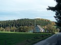
The historic Michaelisweg with the Herbergswald, in which the Bürenbruch Youth Hostel was located, in the background.
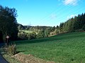
The Michaelisweg seen from the direction of Bürenbruch.
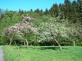
Flowering orchard on Michaelisweg near Wannebach Valley.

Forest damage caused by storm Kyrill in January 2007 in Bürenbruch above Michaelisweg.


Hiking and pilgrimages
The 12 km long “Segensweg” of the Ergster Johannis Foundation with its 12 works of art invites you to hike and linger.
Individual evidence
- ^ Federal Statistical Office (ed.): Historical municipality directory for the Federal Republic of Germany. Name, border and key number changes in municipalities, counties and administrative districts from May 27, 1970 to December 31, 1982 . W. Kohlhammer, Stuttgart / Mainz 1983, ISBN 3-17-003263-1 , p. 334 .
- ^ State Office for Data Processing and Statistics (ed.): Population and private households as well as buildings and apartments. Selected results for parts of the community. Arnsberg administrative district . Düsseldorf 1990, p. 282 .
Web links
- Heimatverein Ergste
- Ergste on schwerte.de
- Ergste and we in the Ruhr valley citizen magazine Ergste
- Ergste in the Westphalia Culture Atlas