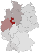
Minden administrative district
| Location (1947) | |
|---|---|

|
|
| Basic data (1947) | |
| Consist: | 1816-1947 |
| Occupation Zone : | Great Britain |
| Country : | North Rhine-Westphalia |
| Administrative headquarters : | Minden |
| Surface: | 5,245 km² |
| Residents: | 1,135,302 (October 19, 1946) |
| Population density : | 216 inhabitants per km² |
| Structure: | 12 urban and rural districts |
| last district president: | Paul Zenz |
| Absorbed in: | Minden-Lippe district |
| Location of the administrative district of Minden in North Rhine-Westphalia | |

|
|
The administrative district of Minden was an administrative district in eastern Westphalia that existed from 1816 to 1947 . For the longest time the administrative district belonged to the Prussian province of Westphalia . With Westphalia, the district fell to the newly formed state of North Rhine-Westphalia in 1946 and merged with the Detmold administrative district the following year . The seat of government was Minden , the largest city in the district is now Bielefeld . The term " Ostwestfalen ", which emerged as a synonym for the district, is still common today, including in the name of the Ostwestfalen-Lippe region .
Administrative history
The history of the administrative district goes back to the Prussian ordinance on the improved establishment of the provincial authorities of April 30, 1815. At that time, Prussia's government and administration were reorganized after the Congress of Vienna and the provinces were divided into a total of 28 administrative districts, one of which was the administrative district of Minden. Like the others, the government in Minden began its work on April 22, 1816.
Historically, this district government goes back to the old Minden government, the creation of which can be traced back to the order after the Peace of Westphalia of 1648. According to its provisions, the Principality of Minden falls to Brandenburg , which initially leaves the seat of government in Petershagen . In 1669 the seat is transferred to the episcopal court in Minden. 1719 the governments of Minden and Ravensberg in Minden for Minden-Ravensberg combined. In 1722 the administration was transferred to the War and Domain Chamber, while the government remained primarily a judicial authority. In 1816 the reorganized government becomes the central administrative authority for East Westphalia, which now also includes the formerly non-Prussian areas in southern East Westphalia.
As part of its entry into the lip in 1947 after North Rhine-Westphalia was in the Lippe Punktationen the unification of the territories of Lippe and of the administrative district Minden to a common administrative region East Westphalia based in Lippe Detmold agreed. Despite bitter protests from parts of the civil service and the population of Minden, the authorities moved from Minden to Detmold on April 1, 1947. On June 2, 1947, the district was renamed in accordance with the other administrative districts in the country after its seat in Administrative District Detmold .
Population development
The following overview shows the population of the administrative district of Minden according to the respective territorial status, which remained largely unchanged from 1815 to 1947. The numbers are census results. Until 1861, the information relates to the “customs clearance population”, from 1864 to the “local population”, from 1925 to the resident population and for 1946 again to the “local population”.
|
|
|
|
Administrative division
- Structure 1816:
- Bielefeld district
- Brakel district
- Circle frets
- District of Büren
- District of Halle (Westphalia)
- Herford district
- Höxter district
- Minden district
- Paderborn district
- Rahden district
- Warburg district
- District of Wiedenbrück
From 1816 to 1817 the urban district of Minden existed, which was incorporated into the district of Minden after less than a year.
- Structure 1947:
- City and district of Bielefeld
- District of Büren
- District of Halle (Westphalia)
- City and district of Herford
- Höxter district
- Lübbecke district
- Minden district
- Paderborn district
- Warburg district
- District of Wiedenbrück
District President


- 1816–1825: Karl von der Horst
- 1825–1847: Karl Gottlieb Richter
- 1847–1853: Franz von Borries
- 1853–1858: Friedrich Wilhelm Ernst Peters
- 1858–1866: Moritz von Bardeleben
- 1866–1867: Ferdinand von Nordenflycht
- 1867–1871: Ludwig von Bodelschwingh
- 1872–1881: Hermann von Eichhorn
- 1882-1894: Adolf von Pilgrim
- 1894–1897: Oskar von Arnstedt
- 1897–1899: Alexander von Bischoffshausen
- 1899–1903: Arthur Schreiber
- 1903–1909: Francis Kruse
- 1909–1917: Georg von Borries
- 1917–1920: Rudolf von Campe
- 1920–1933: Paul Hagemeister
- 1933–1943: Adolf von Oeynhausen
- 1943–1945: Günther von Stosch
- 1945–1947: Paul Zenz
literature
- Ernst Siemer: 175 years old: A district government in East Westphalia 1816–1991. A documentation. Published by the District President in Detmold, Detmold 1991. ISBN 3-926505-04-4 .
- Ernst Siemer (arr.): Collapse and new order, from Minden to Detmold . A documentation. Detmold 1987.
- Erich Sandow: From the history of the Detmold government . In: Government of Detmold. Past and present (Festschrift for the inauguration of the new government building on July 7, 1961) Detmold 1961; Special issue 50a, of the Official Gazette for the Detmold administrative district of December 15, 1961.
- L. Bliesternig: The administrative district of Minden. Local studies for school and home . Minden 1880.
- Karl Kneebusch : Guide through the administrative district of Minden . Dortmund 1890.
Web links
Coordinates: 52 ° 17 ' N , 8 ° 55' E


