Bundesstrasse 80
| Bundesstrasse 80 in Germany | |||||||||||||||||||||||||||||||||||||||||||||||||||||||||||||||||||||||||||||||||||||||||||||||||||||||||||||||||||||||||||||||||||||||||||||||||||||||||||||||||||||||||||||||||||||||||||||||||||||||||||||||||||||||||||||||||||||

|
|||||||||||||||||||||||||||||||||||||||||||||||||||||||||||||||||||||||||||||||||||||||||||||||||||||||||||||||||||||||||||||||||||||||||||||||||||||||||||||||||||||||||||||||||||||||||||||||||||||||||||||||||||||||||||||||||||||
| map | |||||||||||||||||||||||||||||||||||||||||||||||||||||||||||||||||||||||||||||||||||||||||||||||||||||||||||||||||||||||||||||||||||||||||||||||||||||||||||||||||||||||||||||||||||||||||||||||||||||||||||||||||||||||||||||||||||||
| Basic data | |||||||||||||||||||||||||||||||||||||||||||||||||||||||||||||||||||||||||||||||||||||||||||||||||||||||||||||||||||||||||||||||||||||||||||||||||||||||||||||||||||||||||||||||||||||||||||||||||||||||||||||||||||||||||||||||||||||
| Operator: |
|
||||||||||||||||||||||||||||||||||||||||||||||||||||||||||||||||||||||||||||||||||||||||||||||||||||||||||||||||||||||||||||||||||||||||||||||||||||||||||||||||||||||||||||||||||||||||||||||||||||||||||||||||||||||||||||||||||||
| Start of the street: |
Bad Karlshafen ( 51 ° 38 ′ N , 9 ° 27 ′ E ) |
||||||||||||||||||||||||||||||||||||||||||||||||||||||||||||||||||||||||||||||||||||||||||||||||||||||||||||||||||||||||||||||||||||||||||||||||||||||||||||||||||||||||||||||||||||||||||||||||||||||||||||||||||||||||||||||||||||
| End of street: |
Hall ( 51 ° 29 ′ N , 11 ° 59 ′ E ) |
||||||||||||||||||||||||||||||||||||||||||||||||||||||||||||||||||||||||||||||||||||||||||||||||||||||||||||||||||||||||||||||||||||||||||||||||||||||||||||||||||||||||||||||||||||||||||||||||||||||||||||||||||||||||||||||||||||
| Overall length: | 106 km | ||||||||||||||||||||||||||||||||||||||||||||||||||||||||||||||||||||||||||||||||||||||||||||||||||||||||||||||||||||||||||||||||||||||||||||||||||||||||||||||||||||||||||||||||||||||||||||||||||||||||||||||||||||||||||||||||||||
|
State : |
|||||||||||||||||||||||||||||||||||||||||||||||||||||||||||||||||||||||||||||||||||||||||||||||||||||||||||||||||||||||||||||||||||||||||||||||||||||||||||||||||||||||||||||||||||||||||||||||||||||||||||||||||||||||||||||||||||||
| Development condition: | two-lane | ||||||||||||||||||||||||||||||||||||||||||||||||||||||||||||||||||||||||||||||||||||||||||||||||||||||||||||||||||||||||||||||||||||||||||||||||||||||||||||||||||||||||||||||||||||||||||||||||||||||||||||||||||||||||||||||||||||
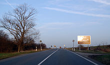
| Bundesstrasse 80 near Arenshausen (sign at the former inner-German border) |
|||||||||||||||||||||||||||||||||||||||||||||||||||||||||||||||||||||||||||||||||||||||||||||||||||||||||||||||||||||||||||||||||||||||||||||||||||||||||||||||||||||||||||||||||||||||||||||||||||||||||||||||||||||||||||||||||||||
|
Course of the road
|
|||||||||||||||||||||||||||||||||||||||||||||||||||||||||||||||||||||||||||||||||||||||||||||||||||||||||||||||||||||||||||||||||||||||||||||||||||||||||||||||||||||||||||||||||||||||||||||||||||||||||||||||||||||||||||||||||||||
The federal highway 80 (abbreviation: B 80 ) is a German national road that leads west to east direction by the country's center and Bad Karlshafen in North Hesse over Lower Saxony and Thuringia with Halle in Saxony-Anhalt connects. As an important west-east connection, the B 80 was largely replaced by the federal autobahn 38 after reunification , so that only two sections of the originally 228 kilometer long route are dedicated as a federal road. The western section leads from Bad Karlshafen through the Weser , Werra and Leine valleys to the A 38 near Arenshausen and is 77 kilometers long. The eastern section connects Eisleben and Halle in Saxony-Anhalt and measures 29 kilometers. The section in between was downgraded to a state road after the motorway was completed.
history
On the stretch from Halle to Eisleben, the first road was built in 1809 . This was later extended several times and expanded into a road from Berlin to Kassel. In 1825 the construction of the road from Halle to Eisleben, which had begun the year before, was completed. It was partially congruent with today's B 80, but deviated from it massively in parts. This ancient route had milestones in three different forms: obelisks at every full mile (Aseleben, Helfta), large bells every half mile and small bells every quarter of a mile. The distance information was based on the starting point Berlin and the closest cities. In addition, road houses were built, some of which have also been preserved. The Chaussee was led from Eisleben via Sangerhausen, Nordhausen, Leinefelde and Heiligenstadt to Kassel, as the milestones still preserved show.
course
The B 80 starts in Bad Karlshafen , the northernmost town in Hesse , which has a small port for shipping on the Weser. "Wesertalstraße" is also the nickname of the B 80, while it runs, always along the river, through the Weserbergland to Hann. Münden (41 km) meanders.
In the "three rivers city" Hann. Münden, where the Werra and Fulda flow together and form the Weser - the B 80 meets the B 3 , crosses the state border to Lower Saxony for a few kilometers and now leads along the Werra to Witzenhausen (60 km), which is again in northern Hesse. Now the B 80 turns slightly to the northeast, leaves the Werra and after seven kilometers crosses the former inner-German border and the current state border to Thuringia and reaches Arenshausen . In 2009, a sign to mark the 20th anniversary of the fall of the Berlin Wall was erected at the former border. Behind Arenshausen the road reaches the federal highway 38 and has been completely downgraded to state roads parallel to it between Arenshausen and Eisleben. Between Werther and Nordhausen , it led over the helmets before the downgrade .
From the junction with the B 180 east of Eisleben, the B 80 leads past the Süßen See to Halle (Saale) , the largest city on the route. Here, the B 80 ends in the middle of the city center at Riebeckplatz and joins the B 6 , which continues to Leipzig , Dresden and Görlitz , and the B 91 , which connects Halle with Zeitz .
The total length of the B 80 (including the section between Arenshausen and Eisleben) is 228 km.
History changes
Section Arenshausen – Eisleben
After the completion of the A 38, the section between Arenshausen and Eisleben was rededicated as the L 3080 state road in Thuringia and the L 151 in Saxony-Anhalt. The road used to lead through the entire Eichsfeld and along the nature park of the same name via Heilbad Heiligenstadt (83 km) to Leinefelde (97 km). From there the B 80 continued between the Ohm Mountains and the Hainleite to the old Thuringian cathedral city of Nordhausen on the edge of the southern Harz (137 km). Here it met federal highways 4 and 243 and led through the Goldene Aue to the state border to Saxony-Anhalt and along the Kyffhäuser Mountains to Sangerhausen (175 km). Behind it was the former copper ore mining area of Mansfelder Land , which is evidenced by many spoil heaps along the route. Finally the Lutherstadt Eisleben (195 km) was reached.
Eisleben – Halle section
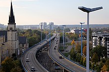
The course of the B 80 between Eisleben and Halle was fundamentally changed in the second half of the 20th century. Originally, the two-lane road led from Eisleben via the communities Aseleben , Seeburg , Langenbogen , Bennstedt and Nietleben to Halle, where it merged with today's B 6 south of Riebeckplatz . This piece was included in the planning for the construction of Halle-Neustadt . Large parts of the B 80 were subsequently relocated and the section between the Seeburg junction and Halle was expanded into a four-lane expressway. Between Seeburg and Bennstedt, the new route was built around one kilometer south of the old route, so that the B 80 completely bypasses or only affects the communities that were previously located directly on it. This section once belonged to the area of the Salty Lake . The old connection was followed between Bennstedt and Nietleben. At the western edge of Nietleben, the course has been changed to the southeast and since 1964 has led in an arc to the south or south-east of Halle-Neustadt, to then cross the Saale in an easterly direction as part of the main line (the most important connection between the old town and new town of Halle). As an elevated road , it finally leads past the Francke Foundations to Riebeckplatz.
See also
Web links
Individual evidence
- ↑ Seeburg - Halle / Saale with four lanes, partially expanded like a motorway
- ↑ Hugo vom Hagen: The city of Halle, according to official sources historically-topographically-statistically represented . S. 411 .
- ↑ Martin Beitz: The milestone locations in the Halle area (Part 2: The Chaussee Berlin - Halle - Kassel and its branches) . In: Meilenstein-Journal , Vol. 37 (2017), No. 73, pp. 25–31.


