Hedemünden
|
Hedemünden
City of Hann. Münden
|
|
|---|---|
| Coordinates: 51 ° 23 ′ 19 ″ N , 9 ° 45 ′ 58 ″ E | |
| Height : | 133 m |
| Area : | 13.27 km² |
| Residents : | 1392 (December 31, 2012) |
| Population density : | 105 inhabitants / km² |
| Incorporation : | 1st January 1973 |
| Postal code : | 34346 |
| Area code : | 05545 |
Hedemünden is a district of the city of Hann. Münden in southern Lower Saxony . The place, which was an independent small town until 1930, currently has 1,392 inhabitants.
Hedemünden is located immediately south of the Benrath line and thus at the transition from the High German - more precisely: the West Central German dialects to the Low German language .
location
Hedemünden lies on the lower reaches of the Werra . This river, which has its source in Thuringia , continues through the Thuringian-Hessian border region and, after the Hessian-Lower Saxony state border, it reaches Hedemünden as the first place in southern Lower Saxony. After the Werra has reached Lower Saxony, its river valley widens to a basin with a diameter of about three kilometers. This valley basin is enclosed in the south by the Kaufunger Forest . Opposite rises in the north the height of the 'Hedemündener Wald'. The mean height of Hedemündens is 130 m above sea level. NN , the highest point is the 'High Loop' with 442 m above sea level.
According to the name researcher Jürgen Udolph , the place name means a towering mountain with a striking slope . Accordingly, the ending -münden , which seems to indicate a confluence, is a more recent development that has displaced an older form -minni (mountain, from Latin mons ).
traffic
In terms of road traffic, Hedemünden is connected to the federal motorway 7 ( Hamburg - Hanover - Göttingen - Kassel - Fulda - Würzburg ) and the federal highway 80 . In addition, Hedemünden has a train station on the Halle – Hann railway line. Münden , this is currently served hourly by Cantus Verkehrsgesellschaft . The trains connect the town with the surrounding medium- sized centers of Hann. Münden and Witzenhausen as well as the regional centers Kassel and Göttingen. In Kassel-Wilhelmshöhe and Göttingen there is a connection to trains of DB Fernverkehr AG .
Hedemünden is also on various tourist routes: the German Fairy Tale Route , the German Half-timbered Road , the German Alps - Baltic Sea Holiday Route and the Werra Valley Cycle Route .
The Hedemünden Werra Valley bridges, on which the motorway and the Hanover – Würzburg high-speed line cross the river, are not in the local area, but about four kilometers west of Hedemünden near Laubach .
history
Already around the birth of Christ there was a Roman legionary camp near the current location of Hedemünden, which is now called the Hedemünden Roman camp . Hedemündens was first mentioned in a document in 1017 when Emperor Heinrich II (the saint) donated his Hademinni court to the Benedictine monastery of Kaufungen (founded by his wife Kunigunde ). The certificate was issued in Altengottern (near Bad Langensalza ) and is now in the Hessian State Archives in Marburg . Hedemünden originally had the name Hademinni, in different spellings also Hademinne, Hedeminni, Haydeminne or Hedeminnen. In 1210, a late Romanesque two-aisled church was built on the site of an early medieval hall church (9th – 12th centuries) . Various extensions and alterations were made later. In 1510 the church and parish build the first schoolhouse on the churchyard wall.
A merchants' guild was mentioned in 1576 , in 1579 Duke Erich, after a memorial of all privileges, gave theo von Hedemünden ... with the righteousness of the shoemaker and Becker guild . A request from the Hedemündener master craftsmen from 1828 to issue a guild letter was refused. In this request there is no reference to the existence of guilds in earlier times. In 1589, Duke Heinrich Julius allowed the town of Hedemünden to levy a purchase price on foreign beers ( licensing ) and its own brewery (brewing right ).
Hedemünden was first designated as a city by Duke Christian Ludwig with the confirmation of his privileges in 1645 . In 1677 hunting rights were granted with confirmation of all privileges. A new schoolhouse with teachers' apartments was built in 1731 on the "cemetery" behind the Michaeliskirche. In 1860 the city of Hedemünden received a constitution as a so-called official city . City rights continued until 1930.
During the construction of the railway from Halle to Kassel via Hedemünden in 1871, the northern of the two large prehistoric burial mounds was removed, while the second, the so-called Haaghügel - although damaged at the edge during the road construction - has largely been preserved. It is the largest prehistoric burial mound in southern Lower Saxony .
With the Jewish cemetery , which was occupied from 1821 to 1895, there is a former Jewish cemetery in the village.
In 1913 the school moved into the newly built school building on Pfuhlweg, which still houses part of the Hedemündener elementary school. With the renunciation of the town charter in 1930 Hedemünden became a rural community again. In 1937 the HaFraBa from Frankfurt to Göttingen was built on the outskirts of Hedemünden . The continuation of the motorway to the north only takes place after the Second World War .
After the construction of extensions to the school house and the additional construction of a gymnasium, the central school for the upper school classes (5th – 9th school year) in the villages of Hedemünden, Oberode, Laubach, Lippoldshausen and Wiershausen was established in 1963 . As a result of the regional reform in Lower Saxony , Hedemünden was incorporated into the city of Münden in 1973, while the old district of Münden became part of the greater Göttingen district. This means that the 5th to 9th grades of the Hedemünden Central School will be transferred to the Hann. Flow together. At the same time, after the Laubacher School had already been integrated, the Oberode and Lippoldshausen elementary schools were also incorporated into the Hedemündener Zentrale-Grundschule that was now created.
On January 1, 1973 Hedemünden was incorporated into the city of Münden.
After the bypass ( Bundesstrasse 80 ) had been completed in 1995 , the dismantling of the former federal road in the town center and the implementation of village renovation measures began .
St. Michaelis Church
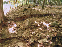
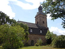
The church is characterized by a mansard roof. Remains of medieval wall paintings were uncovered in the choir in the second half of the 20th century. The current church is located on the site of an early medieval hall church from the 9th to 12th centuries. This building represented a hall church , with a semicircular apse drawn in around the wall thickness of the church and a separated western area. The length of the church was 17 m, its width 8.7 m. In 1210, a late Romanesque two-aisled church was built on the same site, presumably it presented itself as a basilica or hall church . The main nave and the shorter north aisle had semicircular apses and were both vaulted. The main nave was 24 m long, the side aisle 21 m long, the width was 14 m. An early Gothic crucifix can also be found in the church today, like the beehive-shaped bell hanging in the tower from the 14th century. In the late Middle Ages , the church, with its defensive steeple, was the center of a fortification system. Some of the fortifications are still recognizable today through defensive walls and a ditch in front of them. Various additions and modifications are made later.
Commercial location
The place Hedemünden developed due to the directly adjacent Autobahn 7 and the location between Kassel and Göttingen to a commercial location. There are several companies between the motorway exit and the train station, including a logistics hall for a discounter and a sawmill.
With the Hedemünden 2 industrial park developed in 2008 , an area of over 27 hectares is available for companies to settle in. This is the largest open space for commercial settlements in Hann. Münden.
literature
- Heinrich Hampe: Hedemünden - From the history of a small agricultural town up to its renunciation of city rights in 1930 . Hampe, Hedemünden 1992.
Web links
supporting documents
- ↑ a b Heinrich Hampe, Hedemünden: population (as of December 31, 2012) . Retrieved August 4, 2015.
- ↑ That means the place name Hedemünden
- ^ Federal Statistical Office (ed.): Historical municipality directory for the Federal Republic of Germany. Name, border and key number changes in municipalities, counties and administrative districts from May 27, 1970 to December 31, 1982 . W. Kohlhammer GmbH, Stuttgart and Mainz 1983, ISBN 3-17-003263-1 , p. 213 .
- ^ Klaus Grote : Hedemünden in the Werra valley . In: Guide to archaeological monuments in Germany - City and District of Göttingen . tape 17 , 1988, pp. 195 .
- ↑ Information from the city of Hann-Münden on Hedemünden 2 ( Memento of the original from October 7, 2009 in the Internet Archive ) Info: The archive link was automatically inserted and not yet checked. Please check the original and archive link according to the instructions and then remove this notice.


