
Hedemünden Roman camp


The Roman camp Hedemünden is considered to be an early Roman fortification, the remains of which are located near the lower reaches of the Werra on the now wooded castle hill on the edge of Hedemünden , a district of Hann. Mündens , in Lower Saxony . According to archaeological studies, the rich finds of Roman origin suggest a Roman military camp at the time of the birth of Christ.
Along with Kalkriese , the Bentumersiel site , the Roman marching camp of Wilkenburg and the discovery area on the Harzhorn, it is one of the few Roman sites in Lower Saxony.
location
The Roman camp Hedemünden is located about 1.8 kilometers north-west of the Hedemünden town center on the plateau of the castle hill, which is 215 meters above sea level, a largely wooded elevation on the north bank of the Werra . Opposite on the other side of the river is the Kaufunger Wald . At this point, with a river valley about 250 meters wide, the large landscapes of the north Hessian Fulda-Werra-Bergland meet with the Leine-Weser-Bergland in southern Lower Saxony .

The castle hill with the forest area of the Sudholzes lies in a landscape in which the Werra valley widens into an approximately 3 × 3 kilometer basin near Hedemünden. The large basin, known as the Hedemünder Talbecken, passes the Werra in a 50 meter wide river bed; it flows directly towards the castle hill and bends in front of it. The Hüttenbach, which flows into the opposite bank, has formed an alluvial cone that pushes the river to the southern slope of the castle hill. A historic ford runs through the river at the sharp bend in the river. It is based on a shoal where the river is now 0.3 to one meter deep, while downstream at Lippoldshausen the water depth is around 1.5 meters, also due to the backwater of a weir . To the 90 meters lower bank of the Werra loop, the castle hill drops very steeply on its southern flank. Due to modern quarry work, there are cliffs on it. The geological base of the mountain consists of middle- red sandstone , which comes to light at the summit as a red-brown sandstone. On this hill you can still see ramparts today, the so-called Hünenburg .
The castle hill with its lofty location offered favorable fortification and traffic conditions for the construction of the Roman camp. It was set up on its plateau between 180 and 215 meters above sea level. The 50 and 25 meter high steep slopes provided protection on the south and east flanks. The Werra could be crossed by a ford directly below the mountain. This was part of a presumably since the Bronze Age existing old route of what is now northern Hesse from today's southern Lower Saxony. The Hedemünder basin is considered one since the Middle Neolithic existing settlement area considered evidence in favor of a Iron Age Germanic settlement during the Roman presence. At that time, the river was an important traffic route for supraregional trade, so there was an important traffic junction below the castle hill, the importance of which only declined in the Middle Ages .
Discovery story


The ring wall visible above ground on the castle hill was recognized as such in the course of the 19th century. It was regarded as a refuge of the younger pre-Roman Iron Age , which is believed to have been re-used in the Middle Ages in the same function in the 11th and 12th centuries.
As early as 1854, a treasure trove with Roman coins in a clay vessel was made in the wider area of the castle hill east of Hedemünden . The site is located between Hedemünden and Ellerode "Im Eichholze" on the route of an earlier long-distance path. Except for two pieces, the types remained unknown, because the rest of the coin find was melted down. Only a part of the Minucia gene and one of the Mamilia gene are mentioned. The latter must be the denar type Cra 362/1, minted by C. Mimilius Limetanus in Rome in 82 BC. Have acted. This type is a Serratus , which was quite common among the Roman coins found from the time of Augustus , in the Kalkriese region, for example.
Around 1900, a scientific discussion began about the history of the area in prehistoric, Roman and medieval times. In addition to the aforementioned find of Roman coins and the ring wall on the castle hill, the basis was a find of Bronze Age objects near the ring wall Kring in 1881 and the discovery of barrows in 1871 when the railway was built in the west of Hedemünden.

Carl Schuchhardt described the ring wall on the Burgberg in 1894 as a Hünenburg in Sudholze . He saw a cross ax that was found while piercing a wall while building a road as insignificant for dating the facility. It was later lost in the Hannover Provincial Museum , but was later identified as the Roman Dolabra .
To confirm the old thesis of a fortress on the Burgberg, a small test excavation took place in 1965. She brought Germanic and imported Roman pottery to light. A C14 dating of the found charcoal confirmed its classification in the Iron Age. As it turned out later, the charcoal came from an Iron Age predecessor settlement on this terrain, which was attributable to the native Germanic population.
In 1998, the Göttingen district archeology received information from the numismatist Frank Berger that robbers had been investigating the area on the Burgberg with metal detectors since 1992 . Roman metal objects and especially coins were abducted. Immediate follow-up examinations on the part of the preservation authorities revealed that holes from robbery excavations were present and iron finds had been left behind. The own professional metal detector search led to the discovery of Iron Age metal parts and in 2000 to the discovery of a pilum as a Roman weapon part. The subsequent systematic search from 2001 to 2003 revealed numerous metal finds of Roman militaria , including catapult points and tent pegs . As the suspicion of a Roman camp arose, a test excavation took place in autumn 2003 with a cut through a wall with a trench in front. A dolabra and Roman turntable pottery were discovered. During the archaeological prospecting in the vicinity of the ring wall up to a kilometer away, further enclosed areas and terraces were found that indicated fortifications. Further excavations with corresponding finds in winter 2003 and spring 2004 confirmed the presumption of a Roman military camp .
Excavations

The excavations and prospecting revealed a total of six complexes of terrain. Between 2003 and 2011, 62 excavation cuts were made in storage areas I, II and IV on areas between two and 90 m². Larger extensive excavations were not carried out, mainly because of the difficulties caused by the trees. Around 4.3% of the area has been archaeologically examined, with the largest share of around 1,300 m² in "Camp I".
In 2018, the Lower Saxony state archaeologist Henning Haßmann announced that no further excavations were planned and that the previous soil explorations were sufficient for the research discussion. Investigations would only be carried out if the ground was torn up by storms, animals or forest work.
Terrain complexes
Camp I.

"Camp I" (known as the ring wall "Hünenburg" for a long time, but mistakenly viewed as a Germanic refugee castle ) is an elongated oval facility of 300 by 125 meters with a flat, undulating interior area of 3.2 hectares. This area is surrounded by a rampart / moat 760 meters long, in which four gates between three and five meters wide have been identified. They are located in the middle of the west, east and south flanks and in the south-east. There is no evidence of an additional gate in the north. Wall and ditch were checked by profile cuts. Today the wall has a base width of five to six meters and a height of 0.8 to 1.2 meters. It was probably once constructed as a so-called wood-earth wall, that is, the outer front of the wall was built with a vertical wall of posts and planks . The total height from the base of the trench to the top of the wall is estimated at 3.5 meters. Six iron pioneer axes ( dolabrae ), two hammers and a pioneer shovel were found in various places under the wall . It is assumed that the devices were deliberately dumped during the embankment, which is a unique finding in Roman systems so far. One possible interpretation is the filing of a construction sacrifice .
At a total of three places on the wall there are conspicuous rectangular stone groupings on which wooden towers were probably built.

In the forest floor of the warehouse interior, there are clear traces of buildings above ground, namely as laid rows and squares of large unprocessed sandstone blocks. Obviously, it is about the foundations of timber and clay buildings in half-timbered or plank construction. Think of Horrea as storage buildings with "floating", ventilated floors, but also team barracks and other functional buildings. The excavations confirmed the setting of the stone, for example with evidence of burnt building earth and underground pit installations. The magnetometer survey carried out in "Camp I" in 2005 and 2006 revealed large buildings that could have been buildings as principia and praetorium . According to these traces, there are two large buildings with dimensions of 40 × 10 meters and 60 × 25 meters. A striking feature is an almost square central building with an outer edge length of around 40 meters, in whose area and fore there was a high density of metal parts (coins, fibulas, jewelry). Smaller annex buildings can be seen at three corners of the main building . Excavation cuts in the area of the building exposed stone packings that were part of a paved walkway of the building.
Underground cellar pits were located in several places in the camp. In addition to the construction remains, which can be conspicuously brought into cover with the above-ground stone setting and the distribution of finds, stone-set fireplaces and a field oven should also be mentioned here. Other anomalies in the interior of the wall are several stone piles and mounds of earth. On the basis of coin finds, they can be assigned to ancient times without their purpose being known. It is believed to have a function in connection with the Roman burial mound rite .

In the course of the investigations, around 1,200 shards of vessels were found in “Camp I”, around a quarter of which were local ceramics from the Early Iron Age and three quarters were turntables imported from the Romans (partly oil amphoras). A series of Roman coins was also found. There are also a Aduatuci -Kleinmünze and four indeterminate Celtic coinage. Hand mills , the millstones of which are made from basalt lava from the Mayen mining site in the Vulkaneifel, are evidence of everyday food preparation. As an individual finds for example are Aucissafibel and a phallus amulet to call bronze. What is striking is the large number of iron weapons, tools and implements that go back to the Roman military, such as a sword blade, remains of pilum , spout lance tips, catapult bullet bolts, lance shoes, tent pegs , leather knives, scythes and sickles, construction fittings, awls , chisels and Picks, planer knives, nails and pieces of chain. There are also a large number of typical sandal studs. Harness parts (bridle, yoke) and wagon parts (hub rings and sleeves, axle nails, rim nails, eyelet pins, axle fragments) probably come from the Roman entourage. Finds such as iron slag and technical bronze and lead waste indicate metal processing.
Camp II
"Camp II" is a smaller facility with an almost rectangular floor plan that adjoins "Camp I" to the south and was apparently built as an extension at the same time as it. The interior area is 1.3 hectares. The still existing flat walls in the east and west are about 120 meters long, but have been disturbed to the south by the construction of the railway and quarrying. Today they are only up to 40 centimeters high and three meters wide. The reconstructed length of the wall is around 400 to 450 meters. The wall (probably a wood-earth wall) and the pointed moat are clearly archaeologically proven; where the Spitzgraben filling contains intensive fire residues. This is probably the burned-off remains of a wall reinforcement made of wickerwork with clay plaster. Two C14 analyzes showed the matching dating to the Augustan period. A (fourth) Dolabra, two iron hammer adzes, spout lance tips, catapult bolts, sickle parts, iron nails, sandal nails, tent pegs and construction fittings were found in this area.
Area III
Area III is a western area in front of "Camp I" with a conspicuous concentration of Roman metal objects on 150 by 150 meters. Wall and moat systems are not recognizable here. The finds include a silver coin from the Roman Republic, a copper coin of Augustus (?), A 40 centimeter long pilum pole, a pilum clamp, two catapult bolts, sandal nails, a bell clapper and various building fittings.
Area IV

The presumed "Camp IV" lies to the east below the castle hill. The usable plateau area for a warehouse is 400 × 500 meters and therefore around 20 hectares. The southern flank, located above a steep slope to the Werra lowland, shows the remains of a terrace edge, each with rounded right-angled corners in the west and east. A 20-meter-wide interruption in it represents a possible gate. Scattered ceramic finds and structures in the paved area are noticeable here. The magnetometer prospection on several hectares of area reveals building and pit structures. It was possibly a marching camp.
Area V
Area V refers to four terraces in the upper eastern slope between camps or areas I, II and IV. A division of the transition from camps I and II into area IV is assumed to be a function. The terrace edges are up to three meters high. In one case, the excavations revealed that it was a small, right-angled rampart and moat structure with a burnt palisade, which was attached to the east of camp II. From the other terraces there are already ceramic remains, one of which is a remarkable piece of Terra Sigillata .
Area VI
Area VI is a northern area in front of "Camp I", in which, as in Area III, no ramparts and moats can be seen. But traces of bricked building earth, charcoal and metal objects allowed the definition of the outside area VI. In the area of this plateau there is a swamped water outlet, which probably played a role in the former fresh water supply.
Finds

By the end of 2011, about 2,600 metal objects that can be classified as Roman had been found during prospecting with the metal detector and through excavations. These included 640 larger items such as tools, implements, militaria, 27 Roman coins and around 1,200 nails from Roman sandals ( caligae ); 80 pieces of waste, as well as slag and around 660 small finds.
They allow a comparison with other finds from early imperial camps and places such as Haltern , Xanten , Nijmegen , Kalkriese , Waldgirmes , Hofheim , Dangstetten and Rödgen ( Bad Nauheim ). What is striking is the similarity in size and shape with the Rödgen Roman camp (3.3 hectares) in the Wetterau. The dating is confirmed by the series of coins found. In addition to three older republican silver coins, the bronze coins are decisive. The majority consists of series I Nemausus coins ( aces and dupondias ) dating from 16 to 8 BC. BC in Nemausus, today's Nimes in southern France and reached the advanced legionary bases in the north on the Rhine. From there they were given out in large numbers as pay to the legionaries, so that they are among the main finds of coins in the early field and supply camps in Germania . Thus, the base is Hedemünden in the early phase of the occupation incursions into Germania magna to date, considered Oberaden - horizon is called. At that time (between 12 and 9 BC) the advances were carried out under Drusus von Xanten and from Mainz . The last of these campaigns was 9 BC. From Mainz via Hedemünden to southern Lower Saxony and around the Harz Mountains to the Elbe .
The metal finds were brought to the Lower Saxony State Museum in Hanover for safekeeping and maintenance on August 23, 2012 , where they will be part of a permanent exhibition on the Roman camp in Hedemünden from 2015 . Before that, they were shown at the Lower Saxony State Exhibition 2013 on the Harzhorn event in the Braunschweigisches Landesmuseum . For the presentation, some of the finds were returned to the region on permanent loan, with the excavator Klaus Grote having a presentation in the Hann. Münden presented. In 2013 the permanent exhibition Pilum, Sword and Palisade was opened with 116 finds . The Roman camp Hedemünden in the city museum Hann. Münden opened. The exhibits include weapon parts, military equipment, pioneering equipment, tools, equipment for the train with draft animal harness, building hardware, tent pegs , coins, ceramics and fragments of millstones .
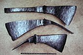
Iron pioneer axes as found objects in "Camp I"

Coins (Nemausus aces), minted in Nîmes between 16 and 8 BC BC, found in "Camp I" (no originals)

Tent pegs

Roman iron implements, including dolabrae, spearhead, pilum point, bolt points


Find the camp's military outposts and advance routes
After the discovery of the Roman camp in 2003, the archaeological field work was extended to the wider area of Hedemünden from 2006 in order to find and reconstruct possible outposts and marching routes for Roman troops. Historical maps and aerial photographs were the basis. In 2010 an area of 13 square kilometers was recorded with the airborne laser scanning method.
During the prospecting , surprising finds were made in today's forest areas, especially in the Kaufunger Forest south of the Werra , opposite the main camp. The ancient route of the Roman troops could be mapped on the basis of numerous metal finds on long stretches that were under forest and not plowed. Typical studs of legionnaires' sandals ( caligae ) were found. A completely preserved iron legionnaire's dagger ( Pugio ) was discovered in a depot situation on the march path from the Kring to the Werrafurt .
In addition, two advanced outposts were located on the marching routes on either side of the camp. To the south-west (towards Kassel) this is the Kring in the Kaufunger Wald, which is in an elevated position and within sight of about 3 km, south-west of the main camp. As early as 2007, the investigation of the ring wall, which had been classified in medieval times, led to finds from ancient times, which then led to the acceptance of an outpost of the Roman camp Hedemünden.
In the north-east direction (towards Göttingen Leinetal), Roman finds were made around five kilometers from the Roman camp near Ellerode, at an elevated point in the forest. Because of the found timber framework with building clay, they point to an earlier observation and signal post that had a line of sight to the Kring, but not to the Roman camp in Hedemünd. Both places provided a series of Roman-Augustan metal finds. The Münzdatierung According they are believed to be associated with the campaign of Drusus years.
Historical and archaeological conclusions

According to archaeological findings, the Hedemünden camp was closed around 11 to 9 BC. Founded. It existed until at least 8 or 7 BC. BC, possibly also until the years after Christ and until the Varus Battle . Ultimately, it may have played a role again in AD 15 and 16 during the Roman campaigns of revenge under Germanicus . The camp was probably set up by Drusus ; the campaign in 11 BC is considered. To the Weser, on which the previously unlocated Aliso camp was founded and the campaign in 9 BC. To the Elbe.
With Hedemünden, an important strategic and logistical camp complex of the Roman advances was discovered, which with its scattered outdoor facilities represented a stable military camp deep in the Germanic area on the right bank of the Rhine. The location was based on the course of an old trunk road that led from northern Hesse to southern Lower Saxony . Here it crossed the Werra, which, as the upper reaches of the Weser, was still navigable around 150 kilometers further up the river and also represented an important supra-regional transport and trade route. To this day Hedemünden is the only fortified Roman camp in Lower Saxony and so far it is the most advanced camp of this type in the Germania magna .
The Roman camp Hedemünden was laid out on an extremely suitable site in terms of terrain above a Werrafurt. The center of the facility was the camp complex I, which had a fortification with a surrounding wooden / earth wall with a ditch. The complex had four gates, several towers and inside had a structure of wooden buildings and tents, with a central building, a horreum and crew barracks. The "Camp II" in the direction of the Werra shows a thinner development, probably with wooden and tent structures. Other surrounding areas were not paved and served as storage areas or training grounds, with Area IV being a larger marching camp. The permanent crew of the facility is estimated at 300 to 500 men. There were also outposts through the Kring small camp on the opposite side of the Werra and an observation point east of Hedemünden near Ellerode.
A monographic overview of the Roman camp in Hedemünde and its outdoor facilities, including the submission of all finds, findings and scientific results, was published in autumn 2012.
criticism
In a publication published in 2014, the former head of the Saalburg Museum Dietwulf Baatz doubts that the facilities on the Burgberg are a Roman warehouse. Baatz argues with the composition of the finds, which is fundamentally different from the known military camps of this era. The complete absence of Terra Sigillata is remarkable , from which large complexes of finds are available from camps such as Haltern and Rödgen . Likewise, disc-turned utility ceramics are only represented with very few pieces. This makes the interpretation as a military camp site extremely unlikely. Due to the large number of metal finds, the composition of the find is more similar to the Kalkriese site or a local sacrificial site of the Alpine campaigns on the Dottenbichl near Oberammergau .
The ring wall and the inner buildings, in particular a central building referred to by Klaus Grote as principia , differ fundamentally from the well-known layouts of Augustan military camps. Baatz therefore suspects a Germanic sacrificial site in the complex on the castle hill, on which the ring wall was only built later in the first century. In his opinion, recent excavations and evaluations are necessary to understand the complex. Siegmar von Schnurbein also joined the critical view in 2014. According to the results presented, a Roman camp cannot be identified in his opinion. Nonetheless, he does not doubt that Hedemünden is an exciting mystery for research.
In the response to Dietwulf Baatz's criticism, published in 2014 by the excavator Klaus Grote, the above-mentioned controversial interpretations are discussed and largely rejected. As shown in the monographic publication by Grote published in 2012, the entire range of finds, including the ceramics found (turntables, broken amphorae, also terra sigillata), point to a secular Roman military installation as well as the excavated findings of wooden building remains and the well-preserved fortifications. In particular, the distribution of the numerous construction clips, tent pegs, tools and technical waste from manual activities within the storage area allows a differentiated reconstruction of the internal structures. More than 1200 typical Roman sandal nails are distributed over the storage areas and reveal inner paths and the intensive inspection of the gates. Overall, the range of finds deviates significantly from the inventories of battlefields such as Kalkriese, Harzhorn or the sacrificial site Döttenbichl near Oberammergau. There are therefore no indications of a possible Germanic (secondary) use as a sacrificial site.
tourism

Around 2010, the Göttingen district suggested using the archaeological site for tourism. In a master plan commissioned by the Göttingen Region Economic Development Agency and announced in 2011 , a visitor and experience center was recommended, the implementation of which would have cost around 14 million euros in full. According to the plans, visitors should cross the site on footbridges five meters high as a circular route so as not to destroy any archaeological sites. The concept encountered difficulties because of the high costs, as the state of Lower Saxony did not want to provide funding for such large-scale tourist facilities.
The head of the excavations, Klaus Grote, rejected the tourism plans. He feared that the mass tourism, with 80,000 expected visitors a year, would cause considerable damage to the site. It still offers considerable archaeological research potential. Instead, he advocates the previously practiced gentle tourism with individual guided tours. Today (2014) the entire site is freely accessible and has a tour with signposted stations.
See also
literature
- Dietwulf Baatz : A Roman camp on the castle hill near Hedemünden (district of Göttingen)? In: Archäologisches Korrespondenzblatt 44, 2014, pp. 229–238.
- Klaus Grote: The Roman military installations of the August German campaigns and references to later advances in the Werra-Leine-Bergland around Hedemünden . In: Gustav Adolf Lehmann, Rainer Wiegels (Hrsg.): Over the Alps and over the Rhine. Contributions to the beginnings and the course of the Roman expansion into Central Europe . In: Treatises of the Academy of Sciences in Göttingen . New episode. Volume 37. Berlin-Boston 2015, ISBN 978-3-11-040846-1 , pp. 191-223.
- Klaus Grote: Hedemünden (district of Göttingen) - More than just a Roman military camp . In: Archäologisches Korrespondenzblatt 44 , 2014, pp. 239–258.
- Klaus Grote: The Roman camp Hedemünden: a decade of research now ended , in: Reports on the preservation of monuments in Lower Saxony . Hameln 2013, 1st ISSN 0720-9835
- Klaus Grote: Roman camp Hedemünden: the Augustan base, its outdoor facilities, its finds and findings. Sandstein Verlag, Dresden 2012, ISBN 978-3-95498-003-1 . Review with details of the content
- Klaus Grote: An Augustan base near Hedemünden on the Werra: the Roman camp and its outdoor facilities . In: Reports on the preservation of monuments in Lower Saxony. 1/2010 ( Online , PDF, 660 kB)
- Klaus Grote: The Roman military base on the Werra near Hedemünden. In: Gabriele Uelsberg (Ed.): War and Peace. Celtic-Roman-Germanic tribes. Catalog of the exhibition in the Rheinisches Landesmuseum Bonn. Bonn and Darmstadt 2007, ISBN 978-3-89678-349-3 , pp. 218-222.
- Klaus Grote: The Roman camp Hedemünden (Werra). The archaeological work until the end of 2007. 3rd preliminary report. In: Göttinger Jahrbuch. 55, 2007, pp. 5-17.
- Klaus Grote: The Roman camp in the Werra valley near Hedemünden (Ldkr. Göttingen). A newly discovered base of the Augustan occupation advances in Germania on the right bank of the Rhine. In: Germania. 84, 2006, pp. 27-59. ISSN 0016-8874
- Klaus Grote: New research and finds in the Augustan Roman camp near Hedemünden (Werra). In: Göttinger Jahrbuch. 54, 2006, pp. 5-19. ISSN 0072-4882
- Klaus Grote: Romans on the Werra. The military camp near Hedemünden in southern Lower Saxony. In: Archeology in Lower Saxony . 8, 2005, pp. 113-117. ISSN 1615-7265
- Klaus Grote: Roman camp Hedemünden . Published by the Mündener Heimat- und Geschichtsverein Sydekum. Hann-Münden 2005, ISBN 3-925451-35-8 .
- Klaus Grote: Base of the Roman expansion policy. The Roman camp near Hedemünden on the Werra. A preliminary report. In: Göttinger Jahrbuch. 52, 2004, pp. 5-12. ISSN 0072-4882
- Klaus Grote: Werra (Augustan camp Hedemünden). In: Reallexikon der Germanischen Altertumskunde (RGA). 2nd Edition. Volume 33, Walter de Gruyter, Berlin / New York 2006, ISBN 3-11-018388-9 , pp. 485-489.
- Dorothea Rohde, Helmuth Schneider: Hesse in antiquity. The chats from the age of the Romans to the everyday culture of the present. Kassel 2006, ISBN 3-933617-26-X , pp. 70-87.
- Ulrich Werz : On the dating of the Roman camp near Hedemünden, district Göttingen, through counterstamped found coins . In: Michael Cell (Ed.): Terra incognita? The northern low mountain range in the field of tension between Roman and Germanic politics around the birth of Christ. Files from the colloquium in the Lippisches Landesmuseum Detmold from June 17th to 19th, 2004 . Philipp von Zabern, Mainz 2008, ISBN 978-3-8053-3632-1 , pp. 187-190.
Web links
- The Roman camp at www.goettingerland.de in the Wayback archive ( Memento from February 10, 2014 in the Internet Archive )
- Representation of the Roman camp Hedemünden on the website of the excavator Klaus Grote
- Article in the RegioWiki of the Hessische / Niedersächsische Allgemeine (HNA)
- Roman camp discovered in Lower Saxony . In: Die Welt, April 25, 2007
- Excavation 2007 with photos
- Topic page Römerlager Hedemünden of the Göttinger Tageblatt since 2009
Individual evidence
- ^ Frank Berger : The coins found in the Roman period in Lower Saxony. Volume 2, Berlin 1988, p. 151 No. 7039.
- ↑ Treasures from the Roman camp remain in the ground in Göttinger Tageblatt of May 26, 2018
- ↑ Archaeologists leave Roman camps alone at ndr.de from May 26, 2018
- ^ "Sensational find" in the Roman camp. Pioneering ax as evidence of ritual building blocks in: Göttinger Tageblatt from August 11, 2010
- ↑ Hanover receives a large Roman treasure . In: Hannoversche Allgemeine Zeitung from 23 August 2012.
- ↑ Wanka fetches Roman treasure from Hedemünden ( memento of August 24, 2012 in the Internet Archive ) . In: Norddeutscher Rundfunk from August 22, 2012.
- ↑ How the Romans were stored in Hedemünden at ndr.de from May 8, 2013 ( Memento from October 24, 2013 in the Internet Archive )
- ↑ New permanent exhibition: The Roman camp Hedemünden in hna.de from May 7, 2013
- ^ Exhibition “Pilum, Sword and Palisade” about Roman camps opened in hna.de on May 12, 2013
- ^ Mündener Stadtmuseum: Exhibition “Pilum, Sword & Palisade” opened in Göttinger Tageblatt on May 12, 2013
- ↑ Romans are not really pulling at hna.de from October 1, 2013
- ↑ Laser beams make Roman camps visible . In: Göttinger Tageblatt of February 22, 2011.
- ↑ Measuring the Roman camp with lasers ( memento of February 27, 2011 in the Internet Archive ) . In: Norddeutscher Rundfunk from February 24, 2011.
- ↑ Ulrich Werz: On the dating of the Roman camp near Hedemünden (p. 189) pleaded based on his investigation of counterstamped found coins for 12 BC. Chr.
- ↑ Klaus Grote: Römerlager Hedemünden: The Augustan base, its outdoor facilities, its finds and findings. Dresden 2012, ISBN 978-3-95498-003-1 ; Roman camp still offers “exciting” potential . In: Göttinger Tageblatt of October 26, 2012; Finds from the Roman camp in Hedemünden . In: Hannoversche Allgemeine Zeitung from November 1, 2012.
- ↑ a b Dietwulf Baatz : A Roman camp on the castle hill near Hedemünden (district of Göttingen)? In: Archäologisches Korrespondenzblatt 44, 2014, pp. 229–238.
- ^ Siegmar von Schnurbein : Hedemünden - a Roman camp? In: Germania 92, 2014, pp. 163–170.
- ↑ Klaus Grote : Hedemünden (district of Göttingen) - more than just a Roman military camp In: Archäologisches Korrespondenzblatt 44, 2014, pp. 239-258.
- ↑ Millions for the Hedemünder Roman camp? In: Norddeutscher Rundfunk from August 29, 2011.
- ↑ Plans for Roman camps probably not to be paid for . In: Hessische / Niedersächsische Allgemeine from March 20, 2012.
- ^ Roman camp Hedemünden: On a journey through time to the legionaries . In: Hessische / Niedersächsische Allgemeine from April 15, 2012
- ^ Reports on the preservation of monuments 2010/1

Flevum | March Camp Ermelo | Roman camp Holsterhausen | Aliso | Roman camp Haltern | Roman camp Olfen | Beckinghausen Roman Camp | Roman camp Bielefeld-Sennestadt | Roman camp Oberaden | Kneblinghausen Roman Camp | Roman camp Anreppen | Roman camp Porta Westfalica | Hedemünden Roman Camp | Roman camp Limburg | Roman camp Oberbruch | Roman camp Lahnau-Dorlar | Roman camp Marktbreit | Roman marching camp near Hachelbich | Roman marching camp from Wilkenburg
Coordinates: 51 ° 23 ′ 44 ″ N , 9 ° 44 ′ 24 ″ E