
Werra-Meißner district
| coat of arms | Germany map |
|---|---|

|

Coordinates: 51 ° 11 ' N , 10 ° 3' E |
| Basic data | |
| State : | Hesse |
| Administrative region : | kassel |
| Administrative headquarters : | Eschwege |
| Area : | 1,024.7 km 2 |
| Residents: | 100,629 (Dec. 31, 2019) |
| Population density : | 98 inhabitants per km 2 |
| License plate : | ESW, WIZ |
| Circle key : | 06 6 36 |
| NUTS : | DE737 |
| Circle structure: | 16 municipalities |
| Address of the district administration: |
Schlossplatz 1 37269 Eschwege |
| Website : | |
| District Administrator : | Stefan G. Reuss ( SPD ) |
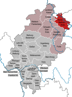
| Location of the Werra-Meißner district in Hesse | |
  |
|
The Werra-Meißner district is a district in the administrative district of Kassel in northern Hesse . The district town is Eschwege .
geography
location
Name factor in the Werra-Meissner on the one hand the river Werra , the coming of Thuringia enters the circle area in the southeast, flows through the northeastern region, with northwest of Witzenhausen leaves the district area again to in Hann. Münden to form the Weser together with the Fulda . On the other hand, it is named after the Hohe Meißner , which is part of the Fulda-Werra-Bergland ( East Hessian Bergland ) and at 753.6 m above sea level. NN height represents the highest mountain in the northeast part of Hesse and the district.
In addition to the Hoher Meißner, the Werra-Meißner district includes the Gobert , Kaufunger Wald , Ringgau , Schlierbachswald and Stölzinger mountain ranges . The district is traversed by the rivers Berka , Frieda , Gelster , Losse , Sontra , Wehre and Werra, among others . A large part of the district area or its north-western part is taken up by parts of the geo-nature park Frau-Holle-Land (Werratal.Meißner.Kaufunger forest) .
Neighboring areas
The Werra-Meißner-Kreis borders in a clockwise direction in the north, starting with the Lower Saxony district of Göttingen , the Thuringian districts of Eichsfeld , Unstrut-Hainich-Kreis , Wartburgkreis and the independent city of Eisenach as well as the districts of Hersfeld-Rotenburg , Schwalm-Eder-Kreis and in Hesse Kassel .
history
The district had belonged to the Landgraviate of Hesse since the 12th century and later to Hesse-Kassel , which rose to become the Electorate of Hesse at the beginning of the 19th century . In 1821 the two districts of Eschwege and Witzenhausen emerged within the electorate , which continued to exist after 1866 when the electorate of Hesse became part of the Prussian province of Hesse-Nassau . As part of the Hessian district reform , both districts were united on January 1st, 1974 to form the Werra-Meißner district . Eschwege became the district town because the city is somewhat more central and larger than Witzenhausen .
Population development
| year | Residents | source |
|---|---|---|
| 1975 | 121,500 | |
| 1980 | 118,500 | |
| 1990 | 116,500 | |
| 2000 | 113,962 | |
| 2010 | 104.027 | |
| 2015 | 100.156 |
politics
District council
The local elections on March 6, 2016 produced the following results, compared to previous local elections:
| Diagram showing the election results and the distribution of seats | |
|---|---|
| Nominations | % 2016 |
Seats 2016 |
% 2011 |
Seats 2011 |
% 2006 |
Seats 2006 |
% 2001 |
Seats 2001 |
|
|---|---|---|---|---|---|---|---|---|---|
| SPD | Social Democratic Party of Germany | 41.8 | 25th | 44.1 | 27 | 49.3 | 30th | 49.4 | 30th |
| CDU | Christian Democratic Union of Germany | 30.7 | 19th | 31.0 | 19th | 31.9 | 20th | 29.3 | 18th |
| FWG | Free voter community Werra Meißner | 10.6 | 6th | 5.9 | 4th | 6.2 | 4th | 7.9 | 5 |
| GREEN | Alliance 90 / The Greens | 7.6 | 5 | 11.8 | 7th | 4.8 | 3 | 5.7 | 4th |
| FDP | Free Democratic Party | 4.9 | 3 | 3.9 | 2 | 5.5 | 3 | 5.6 | 3 |
| THE LEFT. | THE LEFT. | 4.5 | 3 | 3.4 | 2 | 0.4 | 0 | - | - |
| LEFT | Werra-Meißner left-wing alliance | - | - | - | - | 2.0 | 1 | - | - |
| REP | The Republicans | - | - | - | - | - | - | 2.2 | 1 |
| total | 100.0 | 61 | 100.0 | 61 | 100.0 | 61 | 100.0 | 61 | |
| Voter turnout in% | 53.5 | 54.2 | 54.3 | 58.1 | |||||
District administrators
District of Eschwege
- 1868: Karl August Friedrich Groß
- 1885: Emil Grimm
- 1893–1919 Alexander von Keudell
- 1919: Rudolf Bödiker
- 1921: Hermann Langer
- 1932: Otto Glahn
- 1932: 1936 Philipp Deichmann
- 1937–1945 Walter Schultz
- May 8, 1945 - August 31, 1945 Wolfgang Hartdegen
- September 1, 1945 - February 25, 1946 buses
- July 1, 1946 - June 30, 1948 Johannes Braunholz
- July 1, 1948 - June 30, 1954 Gerhard Pforr
- July 5, 1954 - December 15, 1960 Hansjochen Kubitz
- March 4, 1961 - December 31, 1973 Eitel Oskar Höhne
Witzenhausen district
- 1868: Thomas Boch
- 1875: Friedrich Bernstein
- 1884: Bernhard von Schenck
- 1895: Heino von Bischoffshausen
- 1917: Hermann Wolf (from Sulingen)
- 1919: Georg Thöne
- 1928: Jean Groeniger
- 1932: Ernst Beckmann
- 1938: Walter Gerber (from the Reich Ministry of the Interior in Berlin)
- May 21, 1945 - June 29, 1946 Hans Wilhelm von Coelln
- July 1, 1946 - December 31, 1973 Wilhelm Brühbach
Werra-Meißner district
- January 1, 1974 - June 5, 1988 Eitel Oskar Höhne
- June 6, 1988 - June 5, 2006 Dieter Brosey
- since June 6, 2006: Stefan G. Reuss
coat of arms
Blazon : "Above a green three-hill covered with a silver wavy bar behind a silver flank, inside a nine-leaved red ash branch, in blue a single-tower, red-roofed silver castle" (award ceremony November 12, 1976)
The ash branch was taken from the old county coat of arms of Eschwege as a "talking" coat of arms. The Ludwigstein was already contained in the old county crest of Witzenhausen and three mountain with wave beam refers to today's county name.
traffic
train
The north of the district has been part of the Halle – Hann railway line since 1872 . Münden with stops in Eichenberg, Witzenhausen-Nord and Gertenbach opened up. It was followed in 1875 by the Bebra – Eschwege connection , which was extended to Göttingen a year later . Since then, Eichenberg has been an important rail hub. The Göttingen – Bebra railway line later became part of the north-south line . In addition to these two lines and the Kassel – Hessisch Lichtenau Regiotram route, the city station in Eschwege has been served again since December 2009.
Street
The federal motorway 4 (Dresden – Eisenach – Kirchheimer Dreieck) and the federal motorway 38 (Göttingen – Halle / Leipzig) run through the district . In addition, the district area is accessed by several federal and district roads, including the B 7 , the B 27 and the B 451 . In addition, the federal motorway 44 Kassel – Hessisch Lichtenau – Eisenach is under construction.
Communities
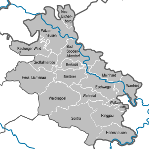

(Residents on December 31, 2019)
|
|
License Plate
On July 1, 1974, the district was assigned the distinctive sign ESW , which had been valid for the Eschwege district since July 1, 1956 . It is still issued today.
Until the 1990s, vehicles from the former Witzenhausen district received license plates with the letter pairs NA to ZZ and the numbers from 1 to 99, later also 100 to 999.
Since September 16, 2013, the license plate liberalization has also made the distinguishing mark WIZ (Witzenhausen) available.
literature
- The Werraland - Heimat-Kunst-Poetry. Eschwege, 1st year 1949 ff. (Quarterly publication of the Eschwege Werratal Association)
- Werraland - Merian issue No. 33. Hoffmann and Campe (special issue), Hamburg 1980, 96 p., Illustrations a. cards
- Erich Hildebrand: Land to Werra and Meißner - A home book. Korbach 1983, 384 pp., Ill. 3rd edition 1990 (revised)
- Hans Joachim Bodenbach: Pre- and early history in the Werra-Meißner-Kreis. In: The Werraland. (Ed .: Werratalverein Eschwege), 36th year, issue 1, March 1984, pp. 2–4, 9 figs.
- Heinz Schlarbaum: Coin finds in the Werra-Meißner district. From the activities of the Eschwege Working Group for Prehistory and Early History, (1st part): [Celtic and Roman Age finds]. In: Das Werraland, 37th year, Eschwege 1985, issue 1, March 1985, pp. 1–3, 1 illustration [and with a map and drawing of the sites and whereabouts]. 2nd part: Middle Ages . In: Das Werraland 1985, 37th year, Eschwege 1985, issue 2, June 1985, pp. 27–29, 2 illustrations [and with a map and drawing of the locations and whereabouts]. 3rd part: modern times . In: Das Werraland 1985, 37th year, Eschwege 1985, issue 4, December 1985, pp. 64–66, 1 fig. [And with a map and drawing of the locations and whereabouts]
- Klaus Möller: Contributions to Werra-Meißner research , Berlin: Self-published by the Institute for Physical Geography at the Free University of Berlin 1986 -
- Hans Joachim Bodenbach: Walter Miritz (1895–1956) - graphic artist and painter and his work in Werraland. In: The Werraland. Werratalverein Eschwege (Werra), 40th year, issue 1, March 1988, pp. 6–7, with 3 illustrations.
- Hans Joachim Bodenbach: Bronze weapons as archaeological finds in the Werra-Meißner district. In: The Werraland. 41st year, Eschwege 1989, issue 1, March 1989, pp. 1–4, with 1 map, catalog and 3 illustrations.
- Eschweger Geschichtsblätter , Eschwege 1990 ff. Self-published by the Eschwege History Association [annual journal]
- Hans Joachim Bodenbach: Equipment made of bronze as archaeological finds in the Werra-Meißner district. In: The Werraland. 42nd year, Eschwege 1990, No. 2, June 1990, pp. 32–34, with 1 map, catalog and 2 figs.
- Manfred Lückert: The Werra - historical photos and reports . Bad Sooden-Allendorf 1990, 278 pages, approx. 320 photos
- Thomas Wiegand: Luxury and Country Life - Historic Castle and Manor House Architecture in Werraland - Eschwege 1990, Fig.
- Herbert Fritsche : Trade, handcraft and economy in transition - blue haze and water of life. From the history of tobacco and brandy. Eschwege / Werra 1990, p. 11–82 (with numerous color illustrations)
- Ulrich-Dieter Oppitz: Bibliography of the Werra-Meißner-Kreis. Eschwege 1991, 2nd edition, 532 pages, 3rd digital edition: http://www.vhghessen.de/eschwege/Bibliographie_WMK_Stand_2020_05.pdf
- Hans-Georg Stephan: Tiles from the Werraland - The development of stove tiles from the 13th to the 17th century in the lower Werra area (writings of the Werratal Association Witzenhausen, issue 23 - 1991) Witzenhausen 1991
- Peer Zietz, Thomas Wiegand (published by the State Office for Monument Preservation Hessen): Werra-Meißner-Kreis I, Altkreis Eschwege (monument topography Federal Republic of Germany / cultural monuments in Hessen) , Braunschweig / Wiesbaden 1991, 677 pp.
- Herbert Fritsche: Trade, handicraft and economy in transition - thread, warp, weft .... Of cloth makers, linen weavers and Hessian sheep. Eschwege / Werra 1991, p. 11–78 (with numerous b / w: and color illustrations)
- Susanne Jacob, Thomas Wiegand (published by the State Office for Monument Preservation Hessen): Werra-Meißner-Kreis II, City of Eschwege (monument topography Federal Republic of Germany / cultural monuments in Hessen) , Braunschweig / Wiesbaden 1992, 416 pp.
- Herbert Fritsche: Trade, craft and economy in transition. That goes on (not) a cow skin . Vom Leder, Schustern und Schuhe Eschwege / Werra 1992, pp. 11–94 (with numerous color illustrations)
- Herbert Fritsche: "Over hill and dale." From carters, stick makers and whip makers in the land on the Werra. In: Handel, Handwerk und Wirtschaft und Wandel, Eschwege 1993, pp. 17–94 (with many color illustrations)
- Karl Kollmann (editor): History of the city of Eschwege , Eschwege 1993, self-published by the city of Eschwege, 530 pp., Illustrations, maps as an attachment
- Herbert Fritsche: "Two irons in the fire ..." . Blacksmiths and locksmiths, plumbers and tinkers in the land on the Werra. In: Handel, Handwerk und Wirtschaft im Wandel, Eschwege 1995, pp. 11–89 (with many black and white and color images)
- Peer Zietz (edited by the State Office for Monument Preservation Hesse): Werra-Meißner-Kreis III, Altkreis Witzenhausen (monument topography Federal Republic of Germany / cultural monuments in Hesse) , Braunschweig / Wiesbaden 1995, 728 pp.
- Karlfritz Saalfeld: Small monuments in the Werra-Meißner district . A first documentation. Writings of the Werratalverein Witzenhausen, issue 28, Witzenhausen 1995, 329 pages with many illustrations
- Herbert Fritsche: "We were lucky ..." . Butchers, pigs and "ahle Wurscht". In: Handel, Handwerk und Wirtschaft im Wandel, Eschwege 1996, pp. 11–126 (with many black and white and color images)
- Udo Bernhardt, Dagmar Kluthe: People between Werra and Meißner. [large-format picture and text volume, 110 pages] Eschwege 1997
- Wolfram Brauneis: List of bird species in the Werra-Meißner district with information on the degree of endangerment. (Writings of the Werra Valley Association Witzenhausen, issue 34). Witzenhausen 1997, 112 p., Fig.
- Herbert Fritsche: "Breads, bezels, wide cakes ...." . In: Handel, Handwerk und Wirtschaft im Wandel, Eschwege 1997, pp. 13–125 (with many black, white and color images)
- Herbert Fritsche: "The mill rattles ...". About mills, millers and flour in the land on the Werra. In: Handel, Handwerk und Wirtschaft im Wandel, Eschwege 1998, pp. 13–133 (with many black and white and color images)
- Hans Joachim Bodenbach: A Hessian watermill in the Eifel? Comments on an Eifel book. A gloss in: Monument preservation & cultural history. State Office for Monument Preservation Hesse 1/2000, Wiesbaden 2000, pp. 62–64, 5 figs. (2 of them in color)
- Verlag Kommunikation & Wirtschaft (ed.): Werra-Meißner-Kreis - Perspectives for the 21st century. (German districts in portrait), Oldenburg 2003, 112 pp.
- Manfred Lückert: The Werra , landscape and life on the river between the Thuringian Forest and Hann.-Münden. Bad Langensalza: Rockstuhl 2006, 304 p., 433 historical figs.
- Karl Kollmann, Klaus Liebeskind: Eschwege in transition - changes in the cityscape in comparison. Geiger, Horb am Neckar 2008, ISBN 978-3-86595-256-1 .
- Thomas S. Huck, Thomas Wiegand: Eschwege-A cultural history city guide, ed. by Karl Kollmann and York-Egbert König for the Eschwege History Association in the Association for Hessian History and Regional Studies 1834 e. V. , Kassel 2009 (3rd updated and expanded edition)
- August Trinius: Through the Werra Valley - from the source to the mouth. A traveling book, Leipzig 1910. Reprint. Bad Langensalza: Rockstuhl 2011, 286 pp.
- Werra-Meißner Museum Association: Museums: Places of experience & more , Eschwege: no year (2013), brochure, four-color
- BVB Verlagsgesellschaft (publisher): Chronicle of the Werra-Meißner district , on the occasion of the 40th anniversary of the district's foundation, Nordhorn 2014 (2014/2015 edition), 130 p., Numerous. Fig. Online edition
- Wolfram Brauneis: General bird guide through the Werra-Meißner district. Booklet 42 of the publications of the Werratalverein Witzenhausen, 2016, 304 p., With hundreds of color photos.
Web links
- Website of the Werra-Meißner-Kreis
- Werra-Meißner district. Historical local dictionary. In: Landesgeschichtliches Informationssystem Hessen (LAGIS).
- Link catalog on the subject of Werra-Meißner-Kreis at curlie.org (formerly DMOZ )
- Habitat Werra-Meißner
- Geo-Naturpark Frau-Holle-Land (side of the nature park that covers the Werra-Meißner district)
Individual evidence
- ↑ Hessian State Statistical Office: Population status on December 31, 2019 (districts and urban districts as well as municipalities, population figures based on the 2011 census) ( help ).
- ^ Federal Statistical Office (ed.): Historical municipality directory for the Federal Republic of Germany. Name, border and key number changes in municipalities, counties and administrative districts from May 27, 1970 to December 31, 1982 . W. Kohlhammer, Stuttgart / Mainz 1983, ISBN 3-17-003263-1 , p. 416 .
- ↑ Statistical Yearbook for the Federal Republic of Germany 1976
- ^ A b Michael Rademacher: German administrative history from the unification of the empire in 1871 to the reunification in 1990. Werra-Meißner-Kreis. (Online material for the dissertation, Osnabrück 2006).
- ↑ Hessian State Statistical Office
- ↑ Population in the administrative districts on September 30, 2010 and population processes in the 3rd quarter of 2010. Hessian State Statistical Office, archived from the original on May 10, 2011 ; accessed on May 31, 2019 .
- ↑ Population in the administrative districts on June 30, 2015 and change in population in the 2nd quarter of 2015. Hessian State Statistical Office, archived from the original on March 24, 2016 ; accessed on May 31, 2019 .
- ^ Hessian State Statistical Office: Results of the district elections of 2016 and 2011
- ^ Hessian State Statistical Office: Results of the district elections of 2011 and 2006
- ^ Hessian State Statistical Office: Results of the district elections of 2006 and 2001
- ^ Hessian State Statistical Office: Results of the district elections of 2001 and 1997
- ↑ 2006 election: WASG
- ↑ District of Eschwege administrative history and district list on the website territorial.de (Rolf Jehke)
- ↑ http://www.werra-meissner-bahnen.de/inhalt/eisenbahnen.html Railways in the Werra-Meißner district
- ↑ Hessian State Statistical Office: Population status on December 31, 2019 (districts and urban districts as well as municipalities, population figures based on the 2011 census) ( help ).
Counties: Bergstrasse | Darmstadt-Dieburg | Fulda | Casting | Gross-Gerau | Hersfeld-Rotenburg | Hochtaunuskreis | Kassel (Country) | Lahn-Dill-Kreis | Limburg-Weilburg | Main-Kinzig-Kreis | Main-Taunus-Kreis | Marburg-Biedenkopf | Odenwaldkreis | Offenbach (State) | Rheingau-Taunus-Kreis | Schwalm-Eder district | Vogelsbergkreis | Waldeck-Frankenberg | Werra-Meißner district | Wetteraukreis
Independent cities: Darmstadt | Frankfurt am Main | Kassel | Offenbach am Main | Wiesbaden