
List of administrative districts and cities in Hessen
The state of Hesse is subdivided into a total of 21 districts and five independent cities . This list of administrative districts and independent cities in Hesse gives a general overview of these including their most important data. The current administrative structure of the country came about through the district reform from 1972 to 1979 , in which the previous 39 districts and nine independent cities were restructured. The town of Lahn, formed in 1977, had no existence, consisting of the towns of Gießen and Wetzlar 15 km away and 21 other districts, some of which were very village-like. After fierce resistance, the city of Lahn was dissolved after only 31 months.
With an area of 21,114.9 square kilometers, the state of Hesse is the seventh largest state in the Federal Republic of Germany . In terms of population, it ranks fifth with 6,288,080 people. The average population density is 298 inhabitants per square kilometer, although this can vary greatly within the individual districts. The population density in the independent city of Frankfurt am Main is 3074 inhabitants per square kilometer, in the Main-Taunus district 1073 inhabitants per square kilometer and in the Vogelsberg district only 72 inhabitants per square kilometer. The most populous district is the Main-Kinzig district with 420,552 inhabitants, the poorest in the Odenwald district with 96,703 inhabitants. The largest independent city is Frankfurt am Main with 763,380 inhabitants. The largest district in terms of area is the Waldeck-Frankenberg district , which, with 1,848.44 square kilometers, ranks 38th in terms of the size of the districts in Germany. The smallest district is the Main-Taunus-Kreis with 222.39 square kilometers.
The urban and rural districts have been assigned to three, previously two administrative districts since 1981 :
| Administrative district | coat of arms | Administrative headquarters | Counties | independent cities |
|---|---|---|---|---|
| Darmstadt administrative district |
|
Darmstadt | 10 | 4th |
| Giessen administrative district |
|
to water | 5 | 0 |
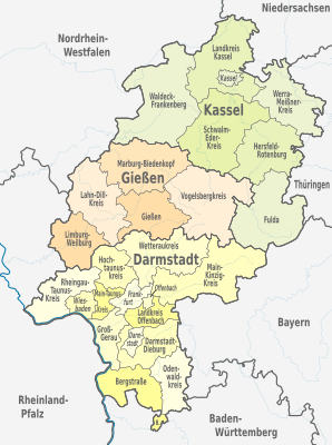
| Kassel administrative district |
|
kassel | 6th | 1 |
| State of Hesse |
|
Wiesbaden | 21st | 5 |
construction
The following list is structured as follows:
- District, independent city: Name of the district or the independent city
- District town: Name of the district town: The cell is empty for urban districts.
- Coat of arms: the official coat of arms of the district or the independent city
- Reg.-Bez., Location: administrative district and location map of the districts or cities within the state of Hesse
- Motor vehicle: vehicle registration number of the respective regional authority
- Ew: Population of the respective regional authority as of December 31, 2019
- Area: Area of the respective regional authority in square kilometers (km²)
- Ew / km²: population density in inhabitants per square kilometer
- Comments: further information on the geographical features of the respective cities and districts, including mountains, rivers and larger lakes
- Image: a typical image from the region with which the respective regional authority is identified
Overview
| District, independent city |
County seat | coat of arms | Reg.-Bez. location |
Vehicle | Ew | Area (in km²) |
Ew./km² | Remarks | image |
|---|---|---|---|---|---|---|---|---|---|
| Mountain road | Heppenheim (Bergstrasse) |

|
Darmstadt
|
HP | 270,340 | 719.52 | 376 | borders on Rhineland-Palatinate and Baden-Württemberg , the Rhine is the western border, the southernmost communities are on the Neckar ; Parts of the Odenwald and the Hessian Ried in the district area; consists of two spatially separated parts; was created in 1938 from the Bensheim and Heppenheim districts |

|
| Darmstadt-Dieburg | Darmstadt |

|
Darmstadt.svg)
|
DA, TU | 297,844 | 658.65 | 452 | borders on Bavaria ; Parts of the Odenwald in the district area; was created in 1977 from the districts of Darmstadt and Dieburg |

|
|
Darmstadt (independent city) |

|
Darmstadt.svg)
|
THERE | 159,878 | 122.09 | 1310 | is nicknamed Science City; Hessian state capital until 1945 ; since 1938 independent city |

|
|
|
Frankfurt am Main (independent city) |

|
Darmstadt
|
F. | 763.380 | 248.31 | 3074 | most populous administrative unit in Hesse; Rivers: Main and Nidda ; Seat of the European Central Bank |

|
|
| Fulda | Fulda |

|
kassel
|
FD | 223.145 | 1,380.4 | 162 | Hesse's highest mountain, the Wasserkuppe in the Rhön , river: Fulda ; borders on Bavaria and Thuringia ; Established in 1972 from the districts of Fulda and Hünfeld , enlarged in 1974 to include the city of Fulda |

|
| to water | to water |

|
to water
|
GI | 270,688 | 854.67 | 317 | River: Lahn ; Landscapes: Wetterau and Vogelsberg ; founded in 1821; 1977–1979 was part of what was then the Lahn-Dill district , the city of Gießen was independent from 1939–1979 |

|
| Gross-Gerau | Gross-Gerau |

|
Darmstadt
|
GG | 275,726 | 453.04 | 609 | Mouth of the Main into the Rhine ; Part of the Hessian Ried in the district area; borders on Rhineland-Palatinate ; founded in 1821 |

|
| Hersfeld-Rotenburg | Bad Hersfeld |

|
kassel
|
HEF, ROF | 120,719 | 1,097.12 | 110 | also known as Waldhessen; Rivers: Fulda and Werra ; Knüllgebirge ; borders on Thuringia ; was created in 1972 from the districts of Hersfeld and Rotenburg (Fulda) |

|
| Hochtaunuskreis | Bad Homburg vor der Höhe |

|
Darmstadt
|
HG, USI | 236.914 | 482.02 | 492 | lies almost entirely in the Taunus ; the highest point is the Great Feldberg ; was created in 1972 from the Obertaunus district and the district of Usingen |

|
| kassel | kassel |

|
kassel.svg)
|
KS, HOG, WOH | 236.764 | 1,292.92 | 183 | borders on Lower Saxony and North Rhine-Westphalia ; Rivers: Fulda , Werra and Weser ; originated in 1972 from the districts of Hofgeismar , Kassel and Wolfhagen |

|
|
Kassel (independent city) |

|
kassel.svg)
|
KS | 202.137 | 106.78 | 1893 | is nicknamed the documenta city; River: Fulda |

|
|
| Lahn-Dill district | Wetzlar |

|
to water
|
LDK, DIL, (WZ) | 253,319 | 1,066.52 | 238 | borders on Rhineland-Palatinate and North Rhine-Westphalia ; Rivers: Lahn and Dill ; was created in 1977 from the district of Gießen to the district of Wetzlar and the Dill district , the capital was the independent city of Lahn , in 1979 Gießen was separated again. |

|
| Limburg-Weilburg | Limburg on the Lahn |

|
to water
|
LM, WEL | 171,912 | 738.48 | 233 | borders on Rhineland-Palatinate ; River: Lahn ; was created in 1974 from the district of Limburg and the Oberlahnkreis |

|
| Main-Kinzig district | Gelnhausen |

|
Darmstadt
|
MKK, HU , GN, SLÜ | 420,552 | 1,397.55 | 301 | most populous area; Hanau was the district town until 2005 ; Main and Kinzig rivers , borders Bavaria ; was created in 1974 from the districts of Gelnhausen , Hanau , Schlüchtern and the city of Hanau; for the city of Hanau only license plate HU |

|
| Main-Taunus-Kreis | Hofheim am Taunus |

|
Darmstadt
|
MTK | 238,558 | 222.39 | 1073 | smallest area in Germany; District with the greatest population density in Hesse; River: Main ; Mountains: Taunus ; was created in 1928 from parts of the Höchst , Königstein and Wiesbaden districts . The district seat until 1987 was Frankfurt-Höchst . |

|
| Marburg-Biedenkopf | Marburg |

|
to water
|
MR, BID | 247.084 | 1,262.55 | 196 | borders on North Rhine-Westphalia ; River: Lahn ; was created in 1974 from the districts of Biedenkopf and Marburg and the independent city of Marburg an der Lahn |

|
| Odenwaldkreis | Erbach |

|
Darmstadt
|
ERB | 96,703 | 623.98 | 155 | most populous district of Hesse; lies in the middle part of the Odenwald ; borders on Bavaria ; originated in 1872 from the districts of Erbach and Neustadt , name until 1972: district of Erbach |

|
| Offenbach | Dietzenbach |

|
Darmstadt.svg)
|
OF | 355.813 | 356.3 | 999 | borders on Bavaria ; River: Main , founded in 1832, Dietzenbach has been a district town since 2002, previously Offenbach |

|
|
Offenbach am Main (independent city) |

|
Darmstadt.svg)
|
OF | 130.280 | 44.89 | 2902 | smallest independent city in Hesse; River: Main ; independent since 1938 |

|
|
| Rheingau-Taunus district | Bad Schwalbach |

|
Darmstadt
|
RÜD, SWA | 187.160 | 811.48 | 231 | borders on Rhineland-Palatinate , river: Rhine ; Mountains: Taunus ; was created in 1977 from the Rheingau district and the Untertaunus district |

|
| Schwalm-Eder district | Homberg (Efze) |

|
kassel
|
HR, FZ, MEG, ZIG | 179,673 | 1,538.51 | 117 | Borkener lignite area from which the Borkener Seenland arises; Rivers: Eder and Schwalm ; was created in 1974 from the districts of Fritzlar-Homberg , Melsungen and Ziegenhain |

|
| Vogelsbergkreis | Lauterbach (Hesse) |

|
to water
|
VB | 105,643 | 1,458.99 | 72 | the most sparsely populated district of Hesse; named after an extinct volcano Vogelsberg ; was created in 1972 from the districts of Alsfeld and Lauterbach |

|
| Waldeck-Frankenberg | Korbach |

|
kassel
|
KB, FKB, WA | 156.406 | 1,848.44 | 85 | Largest district in Hesse in terms of area; borders on North Rhine-Westphalia ; Kellerwald-Edersee National Park with Edersee (second largest reservoir in Germany); River: Eder ; was created in 1974 from the districts of Frankenberg and Waldeck |

|
| Werra-Meißner district | Eschwege |

|
kassel
|
ESW, WIZ | 100,629 | 1,024.7 | 98 | borders on Thuringia and Lower Saxony ; River Werra ; Berg: Hoher Meißner ; was created in 1974 from the districts of Eschwege and Witzenhausen |

|
| Wetteraukreis | Friedberg (Hesse) |

|
Darmstadt
|
FB, BÜD | 308,339 | 1,100.69 | 280 | Wetterau with river Nidda ; was created in 1972 from the districts of Büdingen and Friedberg in Hesse |

|
|
Wiesbaden (state capital) |

|
Darmstadt
|
WI | 278.474 | 203.93 | 1366 | State capital; Rivers: Rhine and Main , the second largest city in Hesse; On the opposite bank of the Rhine lies the Rhineland-Palatinate capital Mainz ; Thermal and spa town |

|
|
| State of Hesse | 6,288,080 | 21,114.9 | 298 | ||||||
See also
Individual evidence
- ↑ Hessian State Statistical Office: Population status on December 31, 2019 (districts and urban districts as well as municipalities, population figures based on the 2011 census) ( help ).
- ↑ Territorial status: Territorial area in square kilometers - reference date 31.12. - Regional depth: municipalities, joint / association municipalities (accessed online on February 23, 2016)